Treat ’em rough, keep ’em tough
Conservationists need to leave parasites well enough alone.

Conservationists need to leave parasites well enough alone.
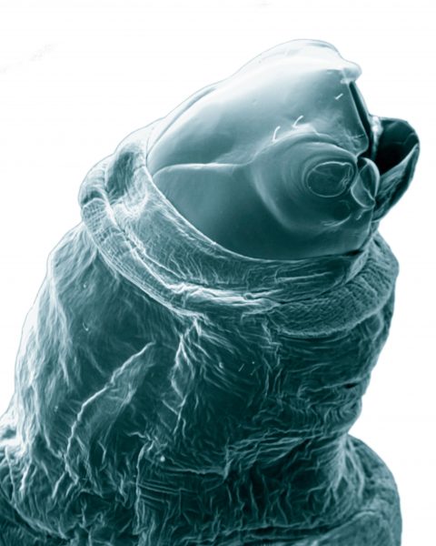
New SEM imagery reveals strange structures on glowworms.
An increase in the salinity of freshwater systems is a death knell for frogs.
Bacteria may reveal where platinum is buried.
Just three words describe any three-metre square on the entire Earth.
… flock together, but moa thrived by being different.
Secrets of blood-suckers revealed.
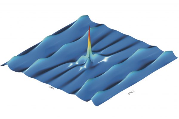
The existence of gravitational waves—ripples in the fabric of space–time—has finally been proven, 100 years after Albert Einstein predicted them. The discovery presents a new way of studying the universe, an opportunity likened to Galileo Galilei’s first use of telescopes to observe the planets. Gravitational waves are not absorbed or scattered by material they pass through, so they allow scientists to look directly into the extreme environments that generate them, such as black holes or neutron stars. This ability to detect gravitational waves adds to the toolbox we use to ‘see’ the universe—as important as x-ray, radio-waves, ultra-violet radiation, and of course the visible spectrum. The Laser Interferometer Gravitational-wave Observatory (LIGO) in the United States detected waves caused by two black holes colliding about 1.3 billion years ago. The LIGO is a massive instrument made up of two observatories operating in unison: one in Washington State, and the other in Louisiana. They each have two arms arranged in an L-shape, each four kilometres long with mirrors at each end. These reflect laser beams back and forward from a centre point and detect interference patterns from vibrations, such as those from gravitational waves. The waves are passing through Earth all the time, but are so small—10,000 times smaller than an atom—that they have been impossible to detect until now. “We have just passed through the threshold from being deaf to the universe, to being able to hear and understand,” says David Blair, director of the Australian International Gravitational Research Centre. “This is the tip of an iceberg. A whole new spectrum is open to us.”
Rouge waves are being re-created using lasers.
Ex ovo omnia- "everything is from an egg"-is a concept unlikely to trouble readers of this journal, unless they were to consider what might hatch from an egg long enough to yield 30 identical slices when hard boiled-and what might have laid such an egg. Visitors to the 21st ECNZ National Science and Technology Fair, held in December at the Museum of Transport and Technology in Auckland, will have it cracked. Anna Pilbrow, a 7th-former at Christchurch's Burnside High School, won the premier technology award for constructing such an egg. Anna saw a need in the catering industry for a "continuous, ready-to-serve" hard-boiled egg, one that would yield more than a paltry four slices. This she created by "rearranging" the contents of many hens' eggs into a long cylinder and hard-boiling the mixture. The resulting tubular mega-egg, apart from its length, shares the characteristics of an ordinary hard-boiled egg, with the added advantage that garnish and colouring may be added before boiling. Food was on the minds of a number of other entrants in the technology category. At Taupo Intermediate, Simon Smith developed a more refined version of the can-on-a-stick fruit picker. Simon's came complete with adjustable pole, collector bag and stalk-cutter. The bag, fitted beneath a neck made from a bottomless tin can, had a baffle system to minimise bruising, while a draw cord and toggle allowed easy release of fruit from the bottom. The cutter, a V-shaped piece of aluminium sharpened along its inner edges, doubled as a guide. The bracket holding the tin can was adjustable, allowing the operator to get at fruit from different angles. Frozen rather than fresh produce was the focus of Orewa College's Lisa Brooks. She noticed that food packaging in her local supermarket freezer was often wet, and that the freezer didn't feel very cold. Was poor storage resulting in food of reduced quality and an increased risk of bacterial infection? Lisa thought an indicator on frozen food packets to show whether they had been stored at the correct temperature would be of interest to shoppers. Such a device would have to alter irreversibly on thawing just once, so customers could see at a glance if defrosting had occurred at any time. After studying the difference between the frozen and unfrozen states, and what changes take place during thawing, Lisa came up with three successful indicators. The first used a small slice of apple, which remained white while frozen but gradually turned brown on thawing: the longer the packet had been defrosted, the browner the apple. The second consisted of a white cotton pad with a non-absorbent X-shaped coating on one surface, placed over a small slab of red-coloured ice (a substance made to a "secret recipe"). If the ice melted, the pad, except for the X, absorbed the red solution. A white X on a red pad, therefore, indicated defrosting. The third was a tick-shaped piece of ice that became a shapeless blob when it melted. Niklas Moore of Matarau School was more concerned about risks to New Zealand's radiata pine plantations than to human health. Would the use of other species to reduce our dependence on a single type of tree be advisable? He had seen bamboo being used for scaffolding in Hong Kong, and pondered its possible uses in this country. Niklas produced a number of different textured bamboo fibres, from which, by mixing them with polyester resin and pressing in a homemade press, he made samples of fibreboard. Tests showed these to be equal or superior in strength to commercially available boards, indicating locally grown bamboo could be a viable alternative in the production of commercial fibreboard for the construction industry. The exhibits of other budding technologists also proved Kiwi ingenuity to be alive and well: a comparative survey of the efficiency and humaneness of various mousetraps available on the market; a home-produced X-Zylo that outflies the commercial model; recyclable plant pots; a mask to be worn while travelling on aeroplanes to combat dehydration; a comparison of the noise levels produced by various items of domestic machinery. In the science category, the premier award went to 4th-former Rawiri Waru of Rotorua Boys' High. Rawiri was interested in the effect of weather on the performance of geysers at Whakarewarewa. To supplement his field observations and background reading, he built two ingenious pieces of apparatus for laboratory tests. The first was a glass geyser, which allowed him to model fluid dynamics. The second was a geothermal simulator, complete with fault lines, hot aquifer, recharge systems, heat chamber, surface reservoir and geyser vents. By blocking off vents, streams and aquifer in various combinations, Rawiri was able to manipulate the circulation system and vary geyser activity accordingly. In particular, he recreated the effect of El Nino weather patterns-dry periods followed by short spells of heavy rain. His combined field and lab data allowed him to propose a model for the operation of Rotorua's famous Pohutu Geyser. Not the boiling waters and sulphurous steam of New Zealand's geothermal areas for Virginia Dawson and Jacinda Ardern of Morrinsville College. They frequented the genteel domain of bowling greens in an attempt to identify and defeat a fungus causing damage to the billiard-cloth lawns. With painstaking effort, the 6th-formers isolated the fungus and ran trials to test a commercially available fungicide. The product proved to be not only expensive but also ineffective, and the pair embarked on the search for a soil bacterium that would do the trick. Samples of forest soil yielded a bacterium that inhibited the growth of the fungus, but not enough. Testing and trialling continues. Also concerned with biological control was Amanda White of Nelson College for Girls. She developed a spray to keep down the numbers of psyllids-lea f-hopping insects-on the sweet-smelling boronia plant, cultivated for oil extraction. After testing the effect of psyllids on plants and researching both traditional. Maori and conventional methods of bug control, Amanda concocted a spray made from ngaio leaves, soap and water, which proved efficacious. Pests of another kind were the focus of Haydn Luckman's project at Auckland Normal Intermediate. "Foreign invaders" such as possums, rats and mustelids cause extensive damage to native fauna and flora, and Haydn sought a means of control. His bait trials suggested a single bait could be developed to attract both herbivores and carnivores, targeting many species in one hit. Amongst the enticing ingredients were cheese, sausage, bacon and egg pie and mutton fat. Such morsels might run the risk of catching humans too! Sailor David Tucker, at Napier Intermediate, was more concerned about controlling the speed of his boat, preferably making it go as fast as possible. Tests on the water to determine whether it travelled more swiftly on a lean or when level indicated heeling to leeward was fastest. However, subsequent mathematical testing using a technique called linear regression proved a level boat was faster under most conditions. And if David ever wondered why his red socks looked maroon after a dunking, he could do worse than ask Christina McCombie and Meredith Rose at Otago Girls' High. They were intrigued that some things look darker when wet. Using a light-tight box of their own construction, with built-in goniometer (an instrument for measuring angles), they plotted the wet and dry reflectivity of various papers, cardboards, cloths, ceramics and painted surfaces. They used their measurements to gauge the predictive powers of the various theories on offer, all of which they found wanting in some degree. Other young boffins rose to the challenge, shedding light on the possible medicinal properties of New Zealand native plants, the effectiveness of different acne-prevention products, the extent of lead pollution in Timaru, the sensory faculties of seagulls, the effect of differing CO, levels on the rate of plant growth and the ecology of the kotukutuku or tree fuchsia. New Zealand's young scientists and technologists continue to do their country proud. Most of the winners of the 1997 national fair will be exhibiting in 1998 at the First Youth Science Festival of Asia Pacific Economic Co-operation in Seoul, and also receive an education scholarship. Year by year, students have earned such rewards through mounting exhibits of increasing sophistication-identifying a problem or need, carrying out intensive research, running rigorous tests, learning from their mistakes and coming up with a new piece of knowledge or application. Some have gone so far as to consider where their discoveries might actually be employed, or how their creation could be marketed, packaged, priced and patented. After all, if an egg can be tubular, why not also golden?
Most visitors to northern New Zealand never pass through border controls. They arrive without visas, delivered by ocean currents from the subtropics, and include marine reptiles, planktonic drifters, molluscs and fish. Some settle here, bringing tropical colour to the reefs of New Zealand's north-east coastal headlands and islands. The currents that bring such creatures here lie on the western boundary of a wind-driven gyre, a slowly rotating anticyclonic whirlpool which circulates surface waters around tile southern Pacific Ocean. Water from the Coral Sea and Great Barrier Reef flows southwards as the East Australian Current. At about the latitude of Sydney the water crosses the Tasman Sea, passing Lord Howe Island and Norfolk Island as the broad meandering Tasman Current. The flow continues around Cape Reinga as the East Auckland Current and runs along the continental shelf edge off the North Island's north-east coast. Among the many creatures these currents deliver to our waters are five species of sea turtle. Turtle sightings go back over 200 years: Joseph Banks and Captain Cook saw a sea turtle from Endeavour near Ninety Mile Beach. The world's largest turtle, the leatherback, which can grow to 2.8 m in length, is the one seen most often. Leatherbacks regularly venture into colder waters and have been reported from the South Island. Others, such as the green and loggerhead, are accidental visitors, and sightings are largely confined to Northland. Venomous sea snakes also find their way here, but our seas (particularly during winter) are really too cold for them. The most frequent such visitor is the yellow-bellied sea snake, an animal that truly "goes with the flow," spending its entire life at sea travelling with currents. It is the world's most widely dispersed reptile, and can be found from the east coast of Africa to the west coast of the Americas. Drifting has its drawbacks, for the snake will die if it is delivered to a cold latitude too far north or south, or if it becomes beached or trapped in a rock pool. Other sea snakes that make rare appearances in New Zealand are the black-and-white banded varieties that can come up onto land. One was found alive on a Te Aroha riverbank in 1945,20 km from the nearest estuary. Most marine animals travel to New Zealand's north-east as tiny planktonic larvae, an intermediate stage between egg and adult. Likely sources for larvae are the islands upstream from New Zealand-Lord Howe Island and Norfolk Island. The East Auckland Current also delivers packets of warm water, creating an environment in which these creatures can settle and grow. Malcolm Francis, a NIWA marine biologist who has studied the distribution of New Zealand fish species, has shown that the north-eastern North Island has about 170 recorded inshore fish species, the highest number for any New Zealand coastal region. Approximately 10 per cent of them are tropical strays that make cameo appearances only during warm periods. Around a third are subtropical in origin, their population centres lying astride the Tropic of Capricorn. Some of them are breeding locally, but their populations are also being restocked by individuals arriving as larvae. Moray eels are an example of a tropical and subtropical group. They spend two to three weeks in the plankton as eggs and then change into larvae several centimetres in length, remaining thus for two to three months. The seven species of moray are also native to such places as Australia, Lord Howie Island and Norfolk Island. An example of a tropical stray is the lionfish, a gaudy species with large poison-tipped pectoral and dorsal fins, seen in 1990 off Ngaio Rock at the Poor Knights Islands. It was a small specimen, probably delivered with the current as a planktonic larval fish. Hard evidence of the life carried to New Zealand by ocean currents can be found on the beach. New Zealand records for tropical molluscs-marine snails, bivalves, nautiloids-are based in many cases on a few recovered shells. Fewer than 100 of our 2000 species of marine molluscs are of tropical or subtropical origin. Margaret Morley, a shell collector and researcher, once found a rare orange-and-white subtropical cone shell (Conus lischkeanus kermadecensis) alive in Parengarenga Harbour. This 6 cm snail remains submerged during the day in the soft intertidal mud, coming out at night to feed, which it does by stabbing marine worms with a single poisoned harpoon-shaped tooth. Specimens of this species have been recovered as far south as White Island. Bruce Marshall of the Museum of New Zealand has suggested that this warm-water cone snail may have established a breeding colony off Spirits Bay, Northland. The rare specimens found along the coastline could originate from larvae produced by this colony or from parents outside New Zealand. Cowries have been found alive off our north-east coast in the last few decades. But some shells found cast up on northern beaches come from creatures that probably do not live here. In this category would be cuttle bones and the shells of chambered nautilus, both from the octopus and squid group of molluscs. These structures hold air-the nautilus shell in its scaled chambers, the cuttle bone in the interstices of its matrix-so can float for great distances, borne by wind and currents. Some warm water species arrive (perhaps on ships rather than as larvae) and become significant components of our fauna, the much cultivated Pacific oyster being a prime example. Others seem to thrive here for a few years, then fade away. One such is a small bivalve, the white file shell Limaria orientalis which became very abundant around northen New Zealand for a few years two decades ago. It otherwise occurs in parts of Australia, the Philippines and Japan. The best way to meet these marine immigrants is to go for a dive or snorkel around some of northern New Zealand's coastal islands and headlands. At the Poor Knights Islands, where the water is one to two degrees warmer than on the coast, many warm-water organisms thrive. They include crimson red toadstool groupers, Lord Howe coral fish, banded coral shrimps, moray eels, long spined sea urchins, cone snails and colourful subtropical sea slugs. Other islands in this warm stream include the Mokohinau Islands, the northern tip of Great Barrier, Mercury, Mayor and White islands. Coastal headlands such as Cape Brett project out far enough to also receive some of this stream of immigrants. Sometimes the larvae-bearing water of the East Auckland Current runs inshore. During the spring and summer months of the late 1980s there were many tropical fish sightings between Cape Reinga and Leigh. These were La Nina years which brought warmer than usual weather to northern New Zealand with more north-east winds. Researchers Malcolm Francis and Jo Evans have reasoned that these winds diverted the East Auckland Current inshore by a frictional effect at the sea surface. What effect is the present El Nino having on New Zealand's northeast? During the spring and early summer months of 1997, cool west to south-west winds prevailed. These winds blew warm surface water offshore and this was replaced by relatively cold water upwelling from the deep. This water was rich in nutrients and when it was exposed to sunshine it became murky-the result of algal blooms. It is unlikely that immigrant warm-water species could comfortably settle under these circumstances. At the time of publication, the winds are following a different pattern which is more like a La Nina than an EI Nino. Tropical northerly winds are prevailing, and the coastal water is warmer than usual. These conditions are more favourable for the settlement and surival of immigrants from the north. We can only wait and see whether this will result in a new influx.
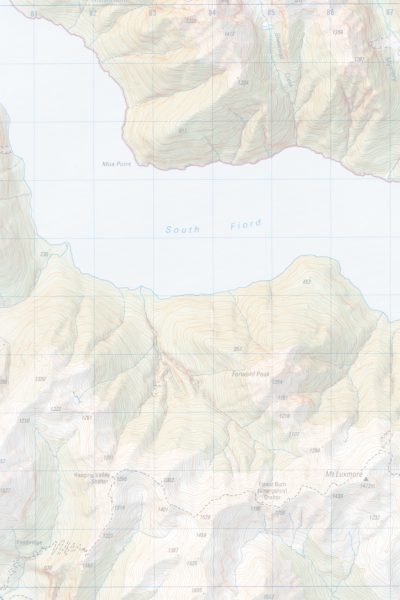
With the recent printing of six topographic sheets of the Fiordland region, maps covering the whole of New Zealand at 1:50,000 scale have now been published, and the last remaining inch-to-a-mile sheets have been withdrawn from sale. The Topographic Map 260 series was initiated in the mid-1970s as a metric replacement for the one-inch-to-one-mile (NZMS 1) series of maps that first came into production in 1939. T h e new series was designed on a specially developed, minimum-distortion projection known as the Map Grid projection. The first sheet, covering Thames, was published in 1976, and at the time it was expected that the whole series of around 310 maps would take 25 years to complete. That the process has been completed ahead of schedule is due largely to technical advances in cartography. In 1976, map production involved the then-modern process of scribing (forming lines by using a sapphire-tipped tool to remove an appropriately wide swathe of a coloured layer from plastic film), application of photomechanically produced lettering on waxed stripping film, cut-and-etch masking for area colours and patterns and film-based reproduction techniques. During the late 1980s a decision was made to begin capturing mapping data in a digital form directly from the photogrammetric instruments that plot surface contours from aerial photographs. The existing collection of 1:50,000 cartographic drawings was to be scanned and vectorised and added to this digital topographic database. Eventually, digital data would be collected for the whole country at a scale of 1:50,000. To take advantage of this new data form, the map-drawing process itself was changed to a computer-assisted design (CAD) system. Improvements in the capabilities of personal computers during the 1990s were critical in allowing the manipulation of the huge files involved in producing digital maps. Traditionally, relief shadings were produced by highly skilled artists; now they are generated on a computer, using digital contour information to produce the shading. The result, while looking slightly softer than the original method, has the advantage of consistency, without the inevitable individual artistic interpretation of landforms. Another advantage of digital production is that map sheets can be made to match their neighbouring sheets much more closely than was previously achievable. And the process is much faster. When maps were drawn by hand, some 30 sheets a year were produced, but with computerisation that output has been doubled. The new Fiordland sheets are among the first to be produced by the fully digitised process. Data for the older sheets in the Topo Map 260 series will all have been digitised by July of this year. Though only one edition of most of the maps has yet been produced, a small number of popular sheets have gone through as many as four editions already. Currently 298 sheets cover the country, but with careful amalgamation there may eventually be only 275. The goal is to complete the digitisation of the data for the whole country and have a map series in which every map is updated every three to five years.
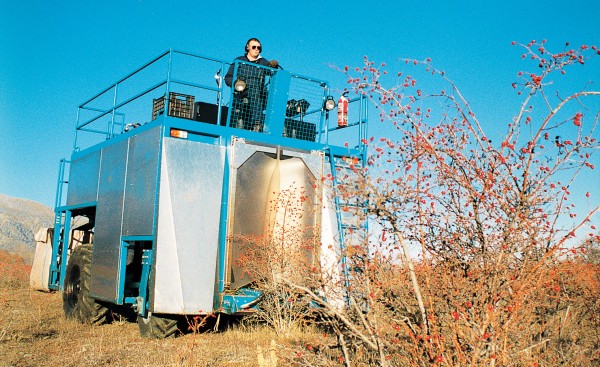
SWEET BRIAR IS widely considered a pest by South Island high-country farmers, but thanks to the efforts of two South African entrepreneurs this thorny bush with its bright red berries is set to transform land use in the Mackenzie Basin. Geoff Hemm and Pete Raal's new company, Rose Products, has begun harvesting and processing rose-hip, the fruit of sweet briar, to meet burgeoning demand in North America and Europe. The two men, who spent six years running a similar business in South Africa before emigrating, have big plans for the crop, and have set their sights on turning this sparsely populated area best known for plagues of rabbits into one of the world's major rose-hip-producing regions. "Last year, between 12,000 and 16,000 tonnes of rose-hip shells were sold worldwide, and we are confident we can capture 50 per cent of that market," says Hemm. To achieve this figure Hemm and Raal say they will require 30,000-40,000 tonnes of fresh fruit each year. This is far in excess of what can be harvested from wild bushes, so the pair have set about convincing the district's high-country farmers to develop sweet-briar plantations on their farms. Raal and Hemm want to bring sweet briar into the mainstream of horticulture, and they will certainly succeed in this aim if the estimated 3000-4000 ha needed are planted. Their campaign is already paying off, with several plantations having been established over the past year, and more and more farmers becoming converts to the cause. City investors are also looking to cash in on the thorny bush's potential. One Dunedin businessman has purchased a farm in tile Mackenzie Basin with the intention of converting it into a 2000-hectare plantation this year. Priscilla and Simon Cameron, who run tile 5800-hectare Ben Ohau station near Twizel, were the first to establish a plantation, and will have 80 hectares of bushes in the ground by mid-1998. The Camerons say that although growing sweet briar is very much a case of learning as they go, tile low establishment costs and relative lack of risk make it a worthwhile diversification option for farmers struggling with low wool prices. "Establishing plantations is well within the capabilities of farmers in the district. If the industry takes off, it could boost the area's rural economy by $10-12 million a year, virtually doubling the basin's existing total farming income. I believe the prospects are very exciting." The rosy outlook for sweet briar comes from the ideal conditions the Mackenzie Basin provides for growing the bush commercially, coupled with rose-hip's health-giving properties and versatility, says Hemm. "Not only does sweet briar grow prolifically here but the flat terrain makes harvesting relatively easy," he says. Rose-hip is a natural product high in vitamin C and can be used in a wide range of goods. Tea can be made from the fruit, the oil can be used in the manufacture of cosmetics, while stock-feed extracts and bio-flavonoids from plant hairs can be used in vitamin tablets." Berries are picked in autumn using a purpose-built self-propelled harvester. Fruit is shaken free by a series of nylon-coated tubes moving at several hundred beats per minute and then fed through hydraulic fans via conveyors to remove debris, before being collected into bags. Up to 1.5 tonnes of berries can be collected per day, depending on terrain and plant density. Harvested fruit is processed at a factory in Twizel using equipment Raal and Hemm brought with them from South Africa. It is dried for 12 to 24 hours, screened to remove impurities, such as small twigs and old berries, then packed in 20-kilogram bags. Establishing a plantation is simple and cheap. Land is cleared of existing wild sweet briar, which is cut up for use as rootstock. Canes are simply pushed into deep-ripped ground with a little fertiliser to encourage rooting and growth. Hemm says that, once established, a plantation requires minimal management: "Sweet-briar plants virtually look after themselves and no disease-control measures are needed, which means our product is free of chemicals-an essential prerequisite for marketing nowadays." Plants take two years to start producing commercial quantities of fruit, with yields peaking from year three to year six or eight, after which the plants need to be pruned. Bushes planted at metre intervals in long rows three metres apart are expected to yield up to three tonnes of rose-hip per hectare on dry land, while plantations on irrigated land could yield up to twice that. With the Twizel factory expected to pay about 35 cents per kilogram, returns of between $1000 and $2000 per hectare are a realistic expectation, says Hemm-far higher than can be achieved from high-country pastoral farming: "The returns are very good considering the low input. It is no get-rich- quick scheme, but the extra income it can provide is very respectable." Raal and Hemm are keen to see a selective breeding programme introduced to boost yields further by developing strains of sweet briar that bear more and bigger fruit. While their operation employs just a handful of people at present, Hemm says if production targets are reached, a much bigger factory will be needed, which could employ 30 to 40 people; on top of this, extra harvesters and drivers would be needed. If the expected economic benefits come to fruition, the much-maligned sweet briar may bring the Mackenzie Basin, if not an agricultural revolution, at least a much-needed boost.
A world awash in plastic...
Hakepa Hill, ignored and almost unknown for the past 80 million years, seems an unlikely candidate for fame. Steep-sided, flat-topped, uncluttered by shrub or tree-it is imposing in its own landscape, certainly, but celebrity material? As it happens, it is an accident of the hill's location rather than any innate quality which is responsible for the peak's rise to prominence. For it is the much-vaunted lookout that affords the first glimpse of each day's dawn-and most notably that of January 1, 2000. Amidst the hoopla, however, some may wonder what it is, this Hakepa Hill, and why it is there. Although Hakepa Hill rises to just 229 m above sea level, it seems much higher and grander than its elevation suggests. It stands up like an Ayers Rock to the Chatham Islands, a welcome sentinel to seafarers and a giant pedestal from which to observe the seemingly infinite expanse of the Pacific Ocean off to the east. The hill is located in the north-east corner of Pitt Island, New Zealand's easternmost populated real estate. In longitude and latitude terms, it is approximately 1760 10.5' Wand 4+0 16.5' S. Strictly speaking, it lies to the east of the 1800 Greenwich meridian, and hence is in the Western Hemisphere, but by a long-established international legal ruling that allows a country to have all its territory within the one hemisphere, it is deemed to lie within the Eastern Hemisphere like the rest of New Zealand. Thanks to this convention, the Chathams can claim to be the first inhabited land to see the dawning of the new day (see New Zealand Geographic, issue 28, for a complete discussion of this vexed topic). Clock-wise, the Chatham Islands are 45 minutes ahead of New Zealand. Pitt Island, on which Hakepa Hill stands, is 15 km long (N-S) and 7 km wide (E-W) at most. It was named Rangiauria by the indigenous Moriori, a Polynesian people living here when the first European visitors landed in November 1791 as part of Vancouver's expedition to the Pacific. The island is distinguished for never having been occupied by Maori, who invaded the Chatham Islands in 1835. Geologically, Hakepa Hill is the remnant of a large lava dome of Late Cretaceous age. It is composed of a distinctive pale-coloured volcanic rock called trachyte, and samples from the summit have been dated, using the potassium-argon method, at 81 plus or minus 2 million years. The eruption that produced this trachyte lava was one of the earliest of a major volcanic episode which gave birth to the Chatham Islands. At the base of Hakepa Hill are the eroded slopes of the older, Middle Cretaceous sediment that the volcano punched through. These sediments are still soft, and are the remnants of ricer and lake deposits that accumulate on a continental landmass about 100 million to 85 million years ago. Lignite seams, well-preserved tree stumps, fossil leaves, wood and pollen testify to an ancient forest and swamp environment. Dinosaurs would have roamed this place (though no bones or teeth have yet been found) at a time when New Zealand was still part of Gondwana. These ancient sediments are the oldest fossiliferous rocks known from the Chathams, and only occur on Pitt Island. The top of Hakepa Hill is remarkably flat, cut by the sea probably within the past five million years. When the sea created this level surface it left a calling card: well rounded pebbles and cobbles, which can be seen near the summit and could only have been formed by moving water, wither in a river or on a beach. They are all that remains of a blanket of sediment that has eroded away as Pitt Island and Hakepa Hill have rise out of the sea. There is much geological evidence in the landscape supporting the idea that the entire land area of the Chatham Islands has risen out of the sea within the Past five million years, and all high points on the islands appear to have flat, wave-cut surfaces. If this theory proves to be correct, then it follows that all freshwater and territorial ecosystems in the Chathams must be very young, for all plants, animals and insects must have arrived since the islands rose above the waves. Such a scenario would have major implications for rates of dispersal, establishment and speciation among terrestrial organism on the Chathams. The top of Hakepa Hill is notable for the presence of at least 12 sink-holes, some of which have been explored. Their depth is unknown, but it certainly tens of metres in some cases. Near the surface, these cool, wet, dark conduits sport some interesting vegetation. They are probably places of refuge for plant species that would otherwise be devoured by the sheep and cattle that graze Hakepa Hill. The holes themselves are erosional features, and may be the remains of hydrothermal fissures or weaknesses in the rock that have become passageways for fluids. Fluids promote the breaking down of minerals to clays, which then erode away. From a distance, Hakepa Hill appears to have livid white patches. These are exposures of bare trachyte poking through the overlying mantle of peat. The peat, up to two metres thick, is considered to be less than 30,000 years old and is dominantly composed of Dracophyllum vegetation and associated swamp plants, which must have thrived (and still do) all over the Chatham Islands during this period. Hakepa Hill is a beautiful, remote place On its eastern flank are several homes that belong to Lanauze family, New Zealand's eastern most permanent inhabitants. They live in one of the most stable part of New Zealand tectonically, far out on the Pacific Plate, 1000 km away from the active collision zone with the Australian Plate that we call the mainland. However, the Pacific Plate is moving in a westerly direction at rates of between 25 and 50 mm per year, so given enough time the Chathams will be somewhere else, and Hakepa will no longer have a claim on being the first place on Earth to see daylight.
One of New Zealand's signature trees—the southern rata, Metrosideros umbellata—has recently been identified as the closest living relative of the ancestor of all Metrosideros species throughout the Pacific. On current understanding, the genus Metrosideros contains some 50 species of trees and woody shrubs distributed from New Zealand's subantarctic islands to almost as far north as Japan and east to Hawaii and Pitcairn Island. It is absent from Australia, Indonesia and Micronesia, but has a major diversity centre in New Caledonia (16 species) as well as in New Zealand, where it is represented by 12 species, from the ubiquitous Christmas- flowering pohutukawa to the extremely rare Bartlett's rata (see sidebar). A group of researchers from the School of Biological Sciences at Auckland University (Shane Wright, Catherine Yong, David Whittaker and Richard Gardner) compared DNA from 36 species and subspecies of one group of Metrosideros to clarify relationships within the group and indicate when they might have become dispersed around the Pacific. The results placed the species into three groups, with our southern rata proving to be the nearest thing to an ancestral species. It appears that there have been at least three migrations of Metrosideros across the Pacific. Perhaps the very first dispersal was of some ancestor resembling M. umbellata from New Zealand to New Caledonia in the later Tertiary period, more than 10 million years ago. The amount of change in the DNA of the various species suggests that around eight million years ago there was a dispersal from New Zealand towards Melanesia and Samoa, and a second from New Caledonia towards Fiji and up towards Japan, each dispersal yielding a group of related species. The DNA of the third group of species has diverged very little from the DNA of New Zealand's pohutukawa, indicating that pohutukawa has spread very recently (in the past million years) from New Zealand. What is surprising is how widely this group has dispersed, for its representatives are found as far away as Tahiti and Hawaii. Since New Zealand has harboured Metrosideros for many millions of years, why did this dispersal not occur much earlier? The researchers think think climate change may provide an explanation. During the Tertiary, the climate was warm and the main winds are thought to have blown from the South-east and not been particularly strong. During the Pleistocene, which commenced two million years ago, ice ages prevailed, and with them came strong westerly winds. Metrosideros seeds are very small and light and can be lofted to high altitudes by the wind. The seeds can also survive a month's immersion in seawater. They are thus equipped for long-distance dispersal on winds blowing in a favourable direction. The ice ages are generally thought of as a time of contracting ranges for plants and animals, but this work suggests that Metrosideros bucked that trend, travelling abroad while other organisms stayed home.
It has long been recognised that New Zealand was once part of the great supercontinent Gondwana, but until recently our link with the ancestral landmass has been based only on fossils and "circumstantial evidence"—New Zealand's geographic proximity to other major components of Gondwana: Australia and Antarctica. Now geologists have found rock strata in New Zealand that have a clear Gondwanan origin. Two localities are involved. The first is the ridge tops just north of Parapara Peak, west of Takaka and within Kahurangi National Park. These rocks are sandstones referred to as the Walker Formation. They are of Early Triassic age (250-245 million years ago) and are virtually identical to sandstones of the same age in Antarctica and Tasmania. Their age has been determined by dating of minerals (zircons). The second locality, within native forest north of Reefton, is a rock)' exposure in the Waitahu River. These rocks are distinctive volcanic rocks referred to as the Kirwans Dolerite. They arc identical in composition to widespread dolerite of Jurassic age in Antarctica and Tasmania. Why has it taken so long to discover these important rocks' Both are very restricted in their distribution and are well "off the beaten track." They have also been extremely difficult to age accurately. These rocks are remnants of a vast blanket of sedimentary and volcanic rocks that is characteristic of Gondwana. The combined influences of rapid tectonic uplift and rapid erosion have all but stripped modern New Zealand of this geological heritage. Only these few remote scraps remain, although more occurrences may turn up deep in the West Coast forest. The term "Gondwana" (or "Gondwanaland") was introduced in the late 1800s, and at that time New Zealand was suspected of being part of this giant continent. Confirmation did not come until the 1970s, with the discovery of distinctive fossil leaves of Glossopteris. Regarded as a probable ancestor of the eucalypts, Glossopteris forest dominated and characterised Gondwana. The New Zealand examples of this fossil are known from Early Permian rocks some 270 million years old, which once formed a chain of islands off the coast of Gondwana but now rest in the Wairaki Hills north of Ohai, in Southland. It is now generally accepted that the New Zealand landmass split from Gondwana around 80 million years ago. But what was before Gondwana? Earth scientists speak of an earlier supercontinent called Pangea, in which all continental land had coalesced as a single entity. Prior to Pangea was an earlier Gondwanaland and Laurasia, and earlier still there was another supercontinental configuration, Rodinia (from Russian, meaning "motherland"). Go back still further and you have the continents of Nena, Atlantica, Baltica, Arctica and, the oldest of all, Ur (from the German, meaning "original"). This plethora of names points to an important geological truth: the continents we see today are by no means fixed entities. Continents come and go, change shape, grow, shrink, split in two, collide, rotate, rise and sink. For example, new research suggests that western North America broke away from the eastern margin of Australia 700 million years ago, and that the Mojave Desert, in California, was once adjacent to Broken Hill. The oldest minerals so far dated from New Zealand are from rocks near Greymouth that accumulated as sand on the sea floor some 490-450 million years ago but crystallised more than three billion years ago. They almost certainly originated from granites in Dr. So New Zealand can be linked right back to the oldest recognised continent on Earth. A fine pedigree, to be sure, but it is with Gondwana that we feel our strongest affection, and the new discoveries in Kahurangi and on the West Coast are a timely proof of that birthright.
Vitamin D deficiencies may be linked to infertility.
Microbes to save the planet, or build another…
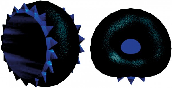
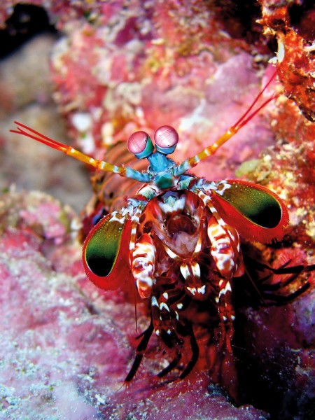
Mantis shrimps have an unbreakable code.
Loading..

3
$1 trial for two weeks, thereafter $8.50 every two months, cancel any time
Already a subscriber? Sign in
Signed in as . Sign out

Ask your librarian to subscribe to this service next year. Alternatively, use a home network and buy a digital subscription—just $1/week...

Subscribe to our free newsletter for news and prizes