Wayfinders
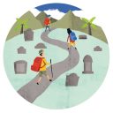
The Paparoa Track, set to open in September 2019, is the first new Great Walk in 25 years, and the first built for shared use between walkers and cyclists. Traversing the coal-rich hills between Blackball and Punakaiki, it will pay its respects to the 29 men who lost their lives in the Pike River Mine.
Hamish Seaton—lean, gumbooted, wearing a hard hat over his baseball cap—stands in a jungle of fallen trees and tangled supplejack vines. Moving in any direction is a mission of scrambling, ducking and clambering in a forest that has been struck by two ex-tropical cyclones and two extreme weather events in the past six weeks.
Seaton’s torn, hole-pocked thermals attest to long days and weeks of bush-crashing. Getting through this terrain is more like acrobatics than tramping, he says. And that’s not the worst of it. One time, he stepped into a wasps’ nest and had maddened hornets up both trouser legs: “I was not a happy man.”
He lifts a device the size of a compass to his eye and sights through it. “Six point five,” he says. Perfect. Six point five degrees is the target gradient for the track Seaton is setting out: the country’s tenth Great Walk, the first to be designed for shared use by trampers and mountain bikers and the first track of any kind to traverse Paparoa National Park.
I have joined him in the upper Pororari catchment, more or less midway between Westport and Greymouth, to watch him work, hoping to see what he sees as he contemplates the trackless forest and decides on a final route. After a year of map studying, route plotting, ground truthing and revising by DOC’s project team, the fine-tuning rests with Seaton, his inclinometer and his eye. Should he take the track above or below this tree, to the left or right of this rock, east or west of a tricky bluff? But always the imperative of averaging 6.5 degrees.

Six point five is the maximum comfortable gradient for sustained mountain biking. If necessary, to avoid having to disturb a stand of venerable trees, Seaton will allow the gradient to reach 10 degrees, but only for a short distance. Inclination rules.
Although the track is intended equally for walkers and bikers, its main features—camber, gradient, the radius of corners, sight lines for seeing the path ahead—are designed for safe and satisfying cycling.
The rationale is that what works for bikers will, with a few tweaks, work for walkers (and trail runners) as well.
In mountain bike track-building circles, Seaton is regarded as having a rare knack for visualising a track’s parameters in his mind before they exist on the ground—and then he tests them himself. He set out the Old Ghost Road cycle trail, 30-odd kilometres north of here, which became instantly popular when it opened in 2015, as well as project-managing the Alps 2 Ocean trail, and has been prominent in Otago mountain biking for decades.
We are at the head of the track. To the east, invisible through the forest, lies the crest of the Paparoa Range, with its northward-stretching string of 1300- to 1400-metre mountains named after scientists: Faraday, Kelvin, Mendel, Curie, Einstein, Priestley, and our own Rutherford (modestly, his is the lowest of the scientist peaks).
To the west, the Pororari River runs down to the coast at Punakaiki, where 450,000 visitors a year come to see ocean spray blasting from blowholes in the Pancake Rocks. Punakaiki will be one of four entrance points for the new Great Walk.
Behind us, newly formed, freshly gravelled track stretches several kilometres down the Pororari valley. Ahead lies a green maze, with twists of pink tape tied to twigs showing Seaton’s route of choice. I admit to him that where he sees a sweet line unfolding within the landscape, I see a maddening multi-choice puzzle.
But Seaton doesn’t just rely on his intuitive eye. Back at the track crew’s camp at Watson Creek, he pulls up a map of the track on his laptop. As the map opens, a spaghetti of contour lines fills the screen. As well as conventional map contours at 100-metre intervals, there’s an overlay of contours derived from LIDAR (Light Detection and Ranging), a remote-sensing technique that produces topographic data at an incredible one-metre resolution—a tremendous asset for a route planner.

Seaton spends an average of a week a month marking the route and walking it with members of the track construction crew, explaining his route choices. For each section he writes a metre-by-metre prescription, full of admonitions such as “big twin tree—no root cutting” and “deepen stream to protect track”.
A week a month is generally sufficient to keep him ahead of the track builders. If the builders are lucky with weather and terrain, they can complete 300 metres of track in a week. Since construction began in August 2017, they have rarely been that lucky. On this side of the range it rained persistently from August until October. “Eight weeks of mud,” one of the track crew told me.
In a clearing a few metres back along the track, amid shovels, rakes, wheelbarrows and drums of fuel, digger-driver Nigel Williams sharpens the teeth of his chainsaw with a file. He will clear the fallen vegetation by chainsaw so he can better visualise his approach with the digger. Deciding the route is Seaton’s job, but it is through the eye and operator skills of Williams and his fellow drivers that the track achieves its final form—its camber, the sweep of its curves, its ability to drain water.

Like Seaton, the digger operators are constantly thinking about gradient. Until they start scraping off the soft humus layer, they can’t tell how deep they will have to go to create a solid track bed.
“If I lose a metre of height to get around a tree or a rock it takes an extra 20 metres of distance to get it back,” says Williams.
Williams makes it sound like geometry and physics, but track project manager Mark Nelson jokes that he is something of a Picasso with his digger arm. Williams laughs: “Mother Earth is my canvas.”
[chapter-break]
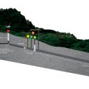
On the other side of the mountain range, at the corner of the road that leads to the Pike River coal mine, Bernie Monk leans his arms against a towering rock and bows his head.
He is standing in the centre of a memorial to the men who died in the November 2010 Pike River disaster, and whose bodies remain in the mine. For the almost eight years since the tragedy, Monk has been a voice for the grieving families of those 29 men, whose lives are remembered here in a circle of 29 stones. He has been a voice of demand for recovery of the men’s bodies and for discovery of what really happened in the days following the explosions.
He leans against the rock as if needing to brace himself against something solid. The whole Pike saga has lacked solid ground. Getting to the truth has been like trying to catch fog. The evasions and obfuscations of bureaucracy have been devastating. Treacherous. Like trying to split wood with a twisted grain.
“We’ve had to work with ten CEOs, ten government ministers and three prime ministers in seven years,” he tells me. Each change has meant starting again to build a new relationship. But the atmosphere of denial has remained palpable, Monk says. “No accountability. No justice.”
Now, finally, the families feel they are making progress. The Pike River Recovery Agency, established in January 2018, is planning re-entry into the mine drift—the 2.4-kilometre tunnel leading into the mine—to gather evidence and recover any remains that may be present. The agency, a stand-alone government entity, has funding of $23 million for the work. It also has an appropriate Māori name, Te Kāhui Whakamana Rua Tekau mā Iwa, which translates as “the empowering voice for the Pike 29”.

Bernie’s wife, Kath, is standing beside their son Michael’s memory stone. Like most of the stones, it has been festooned with flowers and personal items. Kath has their baby grandson Jasper with her and is spinning a toy windmill to keep him happy.
It hits you, the number of people whose lives have been upended by all this—wives, partners, children, parents, siblings.
Behind her, in the distance, are the hills, the mine and the coal. Water from the mine flows into the river that runs past the site. Lines inscribed on the rock in the centre read: “When you look upon these distant mountains remember those who are lost within. Forever on the back shift.”
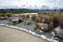
Commemorating the 29 has been a motivation for many generous acts. The very place we’re standing is an example. Farmers Paul and Lorraine Berry donated the land. Paul took a digger to the mine site and gathered the 29 stones from above the portal.
Solidarity and collectivism are values as deeply embedded in West Coasters as the coal is in the mountains. For the families, solidarity goes beyond the 29 killed in the Pike River mine.
“What about all the miners who have died without public recognition?” asks Monk. The families suggested there should be a memorial for all miners who had died on the West Coast. Now 480 names are inscribed on the flood wall of the Grey River/Māwheranui where it runs beside Greymouth.
The Paparoa Great Walk itself was conceived as a memorial. Although the part that has been dubbed the ‘Pike29 Memorial Track’ is a side track to the main traverse, it is the spiritual heart of the project, seen as a fitting tribute to the men who died. That wasn’t a view shared by all the Pike families at the beginning. When the previous government proposed the idea of a commemorative track, some family members saw it as political sop, an attempt to appease them for the decision not to re-enter the mine. Now, with re-entry on the horizon, almost all families are in favour.

Steve Rose, whose stepson Stu Mudge was one of the 29, tells me he backed the track from the start. “The way I saw it, if the track went in, the road would have to stay. And while the road stayed there was a chance of getting back in to the mine. You have to remember that the government told us that the mine would be sealed, the roads would be removed, the bridges pulled up, and that would be it. The track gave us hope.”
Rose is joining Mark Nelson and me to walk the completed section of the Pike29 track.
We are taking time to honour the men’s memory before driving up the road to where the track begins, a few hundred metres below the mine entrance.
This memorial site has been an emotional anchor point for the families, says Rose.
“In the early days, there was a lot of confusion, a lot of mistrust—the families didn’t think they could trust anyone other than each other. We weren’t allowed up to the mine, so this place became the focus of our unity and determination.”
We look at the memorabilia around the stones—licence plates, a car insignia, bottles of beer, cricket wickets, a tool belt. A few of the stones have little embellishment.
“Some of the families just couldn’t cope. And still to this day can’t cope. Some families were split by it.” I write some words in the visitors’ book inside a small shelter that has some photos and a board with the name tags of the 29 men, one to a hook. It’s standard practice for miners to move their tag from the “out” board to the “in” board when they enter the mine. This is the “in” board. The 29 are still in there. Rose dreams of the day when some of those name tags come off the board.
[chapter-break]
We’re driving to the mine, and Nelson is expatiating upon his favourite subject: the craft of track construction.
“Track heritage is my thing,” he says. “My grandfather was a bullocky in the gumfields up north, and I was lucky that when he was in his late 80s, early 90s, he took me into the scrub in Waiorongomai, in the Kaimais, and talked about the old-school track-construction methods.”
Those methods were lost during the mid-20th century, says Nelson, when track builders developed a bulldozer mentality: “That’s when we started to use treated timber, spent less time on surveying, let machinery replace smarts.”
In the past 25 years, there has been a renaissance in the use of traditional methods, driven in part by the mountain-bike boom.
“There are dozens of mountain-bike clubs throughout the country, and each of them has people who want to build new tracks for their sport. That has led to a rediscovery of techniques of hand-building track. It’s a softer, more organic approach. It’s about fitting the track to the land, not the land to the track.”
Nelson quotes an analogy his grandfather gave him.
“Imagine going to the theatre. The curtain opens and there are the actors giving you the story. Everyone needs to look the part and sound like the part. The butler may only have one line, but if he doesn’t sound like a butler or behave like a butler, the spell is broken. With tracks, what you want to do is create the same sense of involvement so users feel part of the landscape. Getting the track to flow with the land makes the experience feel intimate.
“The other part is you make a really good fist of remediation. You want the new track to look like it’s been there for 20 years. So you ameliorate the cut edges and try to remove any signs that builders have been there. That way the people walking and riding can almost imagine they’re the first people who have been there.”
Nelson’s soliloquy ends as we pull up to a locked gate. Not a gate, the gate.
“This gate came to represent everything we hated,” says Rose. The cavalier treatment by officials, the withholding of information, the refusal to budge on mine re-entry. It shut the families out of the mine just as those handling the disaster and its aftermath shut them out of the participation they felt was their right.
Sonya Rockhouse and Anna Osborne, a mother and a wife respectively of contractors who died at Pike River, organised a protest at this gate. Pike River supporters Marilyn and Dave Corson spent 147 days camped in a caravan at the gate in support of the protest.
“Rain, hail and shine, they and their supporters would stand at the gate and turn their backs on the Solid Energy workers as they went through,” says Rose.
The gate is still locked, though Nelson has a key. Twenty-nine effigies are propped up along the side of the road in front of it, and 29 white crosses are painted on the tar seal. Although the effigies are only pieces of timber with crossbeams for arms, dressed in overalls and wearing helmets, they seem disturbingly real, and it’s impossible not to sense the spirit of protest and admire the fortitude of the families. They have held their resolve for seven years in the face of corrosive opposition. Rose says that many times they felt they’d come to the end of the line—a political rock wall as immovable as the one in the mine that blocks access to their loved ones. Then something would emerge, like a thin shaft of light in the darkness. Some photos are leaked. A person with expertise offers a potential solution. Hope is rekindled. The families regroup and push on.
In April this year, Rockhouse and Osborne walked 30 metres into the drift with Pike River Re-entry Minister Andrew Little. It was the first time in seven years they had been able to walk more than a few metres into the mine. It felt symbolic. The further they get into the mine, the closer they come to truth they believe is waiting inside.


We drive on, stopping a few minutes later at a much larger security gate, where Nelson states his purpose through an intercom. The gate slides open and we pass through. The road narrows and crosses the White Knight Stream, then reaches the administrative buildings of the former Pike River mine. These are destined to become an interpretation centre for the story of the development of the mine and subsequent disaster, with the possibility, Rose hopes, of also providing lodging for track users.
For the families, telling the Pike story is essential. Rose says they plan to recreate the mine’s control room and set it to the moment of the first explosion. Video, audio and other storytelling methods will be used to create an immersive experience for visitors, who can take that awareness with them on the track.
We park and walk to the portal. Farm gates span the entrance and have bouquets of plastic flowers tied to them. There is a continuous low-pitched whirring of a ventilation system. Kirk Neilson, a coal mine deputy working for the recovery agency, leans on the gate and talks to us. His face is grey with limestone dust, which he has been spreading to render any coal dust inert and incombustible—though it’s largely a formality, he says, because the mine is no longer operating.
He tells us he’s been for a look up the track, and likes what he sees.
“I’ve been hurrying the boys along, saying I turn 50 next year and I want to get amongst it. I live over at Punakaiki, so I could be riding to work if they get their act into gear. It would be a hell of a commute.”
Neilson’s brother was working in the mine a few weeks before the explosions.
“He told me a few things about the conditions, and I said, ‘Get the hell out of there’. It’s the only time he’s ever listened to me,” he says, cracking a sad smile.
As we leave the portal, Rose invites me to wash the piece of pounamu I wear around my neck in the water that flows out of the mine. Perhaps tragedy makes mystics of us all, but as I hold the stone under the cold, clear water, it’s hard not to think that the men in the mine are somehow watching all this activity on their behalf. Rose certainly thinks they are: “The men are still working for the Coast. Working on the back shift.”
[chapter-break]
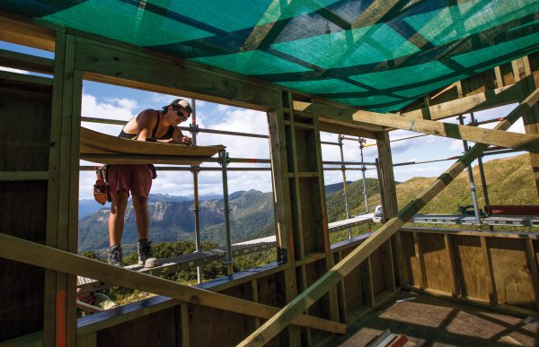
We start up the memorial track and are met by some of the construction crew. The Great Walk is being built by three separate teams simultaneously. This section is being pushed westward by a crew from Nelmac, a Nelson-based company, while the Pororari crew, from Westport company WestReef, works in the opposite direction. A DOC crew is building track on the top of the range to connect the two.
As we walk, Nelson chats to the Nelmac team about progress. There’s an entire lingo for tracks that has the allure of a dialect. A hillside is cut to create a bench. The bench is formed to a single-camber outslope to allow water to drain away. The batter is the backward slope of the inside bank after the bench has been cut. Surfacing material is called top course or pavement. Duff is the living layer of leaf mould, humus, seeds and spores that is used to remediate the track edges.
We come to a boggy stretch that has several dozen metre-long flitches of timber laid side by side across it. This is known as corduroy, and it’s one of Nelson’s favourite heritage techniques for dealing with soft ground. The timber slats will be set in the wet ground and covered with 300 millimetres of pavement to help it stay permanently wet, and in that condition will last for centuries, he says.
Nelson was a shepherd for 15 years, and there’s a shepherdly aspect to his approach to building this track when it comes to trees.

“Every tree is a conversation,” he tells me. We stop beside a podocarp that has become destabilised by wind gusts and could pose a hazard to users. Can they avoid cutting it?
“In the past, this tree would be considered in the way and felled,” says Nelson. “The environmental constraints we’ve put into the project, such as not taking trees or disturbing roots where we don’t have to, foster conversations around what goes and what stays. Because, at the end of it, the forest is what people come to see.”
Tree damage was one of Nelson’s biggest headaches over the summer. Ex-cyclones Fehi and Gita wreaked havoc on the western part of the project. On an overflight by helicopter, I saw a pick-up-sticks landscape of skittled trees. At ground level, I picked my way through a tree avalanche that had buried the track for 30 metres. I saw a brand-new laminated-beam bridge that had been splintered by a direct hit from a falling tree.
“That’s the danger of a podocarp forest,” Nelson tells me. Heavy timber, lateral root balls with no tap root and all intertwined—when such trees come down, they make a mess. And the interlinking of roots means that if one tree falls, it often takes its neighbours with it. Once a hole opens in the canopy, wind gusts can get in and compound the damage.
Flooding also took a toll. During a heavy rain event, two of WestReef’s diggers and a crusher were tipped over by floodwater and damaged beyond repair. I watched cellphone video of water lapping the base of a new suspension bridge a few metres from the Watson Creek camp—the water was running tens of metres higher than its normal level.
I asked Tom Hopkins, DOC’s project director, about the weather risk. I had heard warnings that DOC was buying trouble by putting a Great Walk—intended for popular use rather than for experienced outdoors folk—in the path of some of the country’s most unpredictable weather.
“I don’t think that risk is overstated,” Hopkins said, “but neither is it out of context with some of the other Great Walks. Milford Track can get five or six metres of rain. The Routeburn and the Tongariro Northern Circuit are others that get hit by extreme weather. We’re planning to put in an emergency shelter on an exposed section of track between Moonlight Tops and Pororari Hut, and may have to come up with a flood route in the Pororari valley as well.”
Paparoa Track is the first of the country’s 10 Great Walks that is solely on the West Coast. Its shared-use designation has raised some objections from trampers. The prospect of collisions with pelotons of Lycra-clad urbanites on their expensive carbon-fibre machines is a legitimate concern, but Nelson doesn’t think war will break out between the two tribes of users. He says that the track is designed so that downhill riders get plenty of visual warning about what lies ahead and that such visibility works in reverse as well, for walkers and riders coming up the track. And because the track isn’t designed for speed but for enjoyment of the landscape, its many corners are self-limiting for cyclists.

On a day of persisting West Coast rain, I decide to try out the Pike29 on wheels. I borrow one of the track crew’s electric mountain bikes. This machine, with its fat mud-hugging tyres and grunty motor, takes the hard work out of uphill riding. Such bikes won’t be allowed on the finished track, but the workers use them to commute to the ‘office’.
As I ride, I see the distinctive white wing flashes of tomtits and hear pīwakawaka peeping. When I stop to listen to kea calling above the forest canopy, a robin hops to the edge of the track and tilts its head quizzically.
At the head of the track the crew is just finishing smoko under a triangle of tarp—their only shelter from the rain that’s blotting out views over the Grey Valley. They’re doing hand work today. In this kind of rain, the digger turns the track into a bog.
Then the ride down—the hissing of tyre rubber on wet gravel, the artfully modulated corners, the rain-dripping majesty of the forest. I watch water coursing across the track bed and remember Nelson’s words: “The three elements of track construction are water management, water management and water management.” From what I can see, these criteria are being met.
[chapter-break]
What is a Great Walk anyway, beyond a marketing brand? It is a question that Nelson has pondered. “When we started the project, I looked for a description of what a Great Walk is, and there wasn’t one. I rang someone who’s been in the department for 25, 30 years, who came through from the Forest Service, and whose job is track and structure standards.
I asked him, ‘What’s the definition of a Great Walk?’ He said there is no written definition, it’s a definition in the minds of New Zealanders, and that’s probably the most powerful definition you can have.
To me, it’s about showcasing the best New Zealand has to offer in its best light. Putting people in a natural environment where they go, ‘Wow’.” Does Paparoa have the wow factor? Nelson should know—he led the reconnoitring of the track route.
“When I joined the project, the track was just a line on a map,” he says. “It was by no means certain that we had an achievable route. My first job was to truth it and say, ‘Yes, it can be done’.”
Three teams of two—a surveyor and a track builder—surveyed the entire route. It involved 72 trips over eight months, a massive join-the-dots exercise. Teams would be dropped off in the scrub for a week at a time, to see if they could link up with where they’d been last time. Each section was videoed, photographed and GPS-logged for future reference.
Glamping it was not. “Swamp everywhere, constantly covered in mud—but the sunsets were fantastic,” Nelson says. “Nowhere does sunsets like the West Coast.”
The biggest challenge was seeing whether the track could be built to the 6.5-degree gradient needed for mountain biking. “The pinch points were cliffs, rock, masses of large podocarp in a small area, soft ground, muddy ground, potential traps—all problem-solving issues.”
One of the trickiest sections was up near the highest part of the route, known as the escarpment. It took Nelson two days on hands and knees to find a way down. “But the satisfaction of discovering a corridor through those moss-covered rock walls was immense.”
For the DOC crew building track in this exposed alpine section, the work is a race against the snows of winter. They will have to retreat to lower levels when the metal tools start sticking to their skin.
The crew up here are conscious of the fragility of the environment. They move scree from the track route by hand before the digger comes through, so lizards and insects can get away to safety. Walking off-track is avoided, to spare cushion plants or other prostrate vegetation from being crushed.
It’s slow going for the crew today. The digger has hit a bouldery patch and the driver is clank, clank, clanking the bucket against rocks, trying to dislodge them. His hands on the joysticks are in constant motion, like a video gamer’s, and the machine bucks and jolts with the impacts. I watch him work for 15 minutes to budge a single stubborn boulder. The area is not only rocky but wet, easily churned into a soupy mess. It has taken the crew a week to win a few metres of new track.

They are something of a United Nations outfit. One worker moved with his family from Tasmania to take part in the project. Others are from the United States and France. You can make a life doing this kind of wilderness work, it seems. One of the crew spent 10 seasons at the South Pole, and has cut track in New Hampshire, Arizona, Texas and Costa Rica.
Lucie Daniskova, from the Czech Republic, has developed a special affection for alpine insects. At night, in the hut where the crew stays, she records and tries to classify the ones she finds. She has a keen eye for native birds, too. A flock of seven kea flew over one day. “And kiwi are here,” she says, wonderingly. “We hear them.”
Another taonga bird that users of the new Great Walk may see is whio. One morning, I take part in a release of whio into the Pike River, just below the mine portal. Te Rua Mason, from Ngati Waewae, stands in the river and gives a karakia. He says the little whio flock we’re about to release has been given a name: Kanohi Kitea, the face that is seen.
A lot of Coast history has involved faces not being seen—or people not seeing eye to eye, he says. His people, for instance, for a long time relegated to the sidelines, not recognised as holders of mana whenua. The 29 miners and contractors, whose faces, it could be argued, were not “seen” by the company that allowed their safety to be compromised and lives to be taken. It’s time to see and be seen, Mason says. With that, we pull up the sliding hatches of the duck cages and, as one, six birds fly out and settle on the water, dipping their slate-grey heads and splashing their feathers.
Ngāti Waewae’s face will be seen on the Great Walk in the form of interpretation signage along the route, and there are plans to erect waharoa, gateways, at the three main entrance points. Place names will be presented in dual languages. Some features that have no known names will be given them.
Rauhine Coakley, also Ngāti Waewae, tells me that only six per cent of Māori use public conservation land, and that for her people this track offers a chance to reconnect. For the past two years, Coakley, through her company Hīkoi Waewae, has been offering the chance to walk in landscapes with significance to the iwi. “Walking in the footsteps of tūpuna,” as she puts it.
When her people say their mihi about mountains, rivers and sea, she wants it to be more than words. “We want them to have smelt it, experienced it, walked it.”
History and memory will also be central to the visitor experience at Blackball, the Paparoa Track’s southern gateway. If this Great Walk proves as popular as many others, Blackball’s sleepy small-town serenity could change abruptly.
Members of the Blackball Residents Association Trust (BRATs) have been considering their options—both to take advantage of the flow of visitors to the trailhead a few kilometres north of the town and to preserve Blackball’s small-town ambience. Paul Maunder, a Wellington playwright, film-maker and writer who moved to Blackball 15 years ago and lives in a miner’s cottage next to the town’s open-air swimming baths, says some members of the community are thinking along the lines of co-ops, which fits the collectivist ethos of the town’s past.
“We think there could be two co-ops supporting the track,” he tells me over a cup of tea. “One could do support stuff for the track—shuttles, gear hire such as camping stoves, dehy food, perhaps bike hire—though a lot of money would be needed to set that up. Another could be speciality food and souvenirs—Blackball chocolate, biscuits, hazelnuts. In Reefton, they sell glass vials of coal dust. Accommodation—there’s the Hilton, and people are already doing camper van accommodation and bed and breakfasts, but that would probably increase.”

There are no coal miners living in Blackball these days. This comes as a surprise for a town made famous by the 1908 crib-time strike that was the genesis of the organised trade-union movement. Miners went out for almost three months—over the company’s refusal to increase their lunch break from 15 to 30 minutes. They won.
And Blackball today? “The village has a few professionals—a couple of teachers, midwives, people in the care sector, a couple of government workers—two sawmills, a few digger drivers, a few tradespeople, a few sickness beneficiaries,” Maunder says, listing the townsfolk who come to mind.
Yet Blackball wears its history with pride. The town’s Facebook page has the slogan: “Our future is in our past.” It celebrates May Day each year with sing-alongs of workers’ anthems and a visit from the Cuban ambassador.
Its story is on display in a museum housed in and around a couple of shipping containers next to the town’s iconic ‘Formerly the Blackball Hilton’ hotel. The museum is new since I was last in Blackball, and I’m glad to be reminded of the moral grit of the Blackball miners. At the edge of town are the ruins of a bathhouse that was built as a result of union agitation. Before its advent, coal-grimed miners had to bathe in a tub at home. Lines from a Jeffrey Paparoa Holman sonnet are printed on an interpretation panel: “Here the grateful shoulders lathered, work forgotten in prayers of steam, smoking off the soapy skin… one more shift and not dead yet.”
The new Great Walk will bring this story into view for people who may know very little about the history of unionism, activism or underground mining. (Even the town’s new public toilet will contribute to the narrative—it will be in the shape of a miner’s helmet.)
And as the words on a memorial behind the Blackball museum say, it will make visible the lives of “all who went to work but never came home”.