Landfall
What force of nature kills more New Zealanders than volcanoes, tsunamis and earthquakes combined? Landslides. With climate change making landslides more frequent, and the South Island overdue for a big quake, scientists are racing to understand the risk. But the tricky part is translating that existential maths into action.
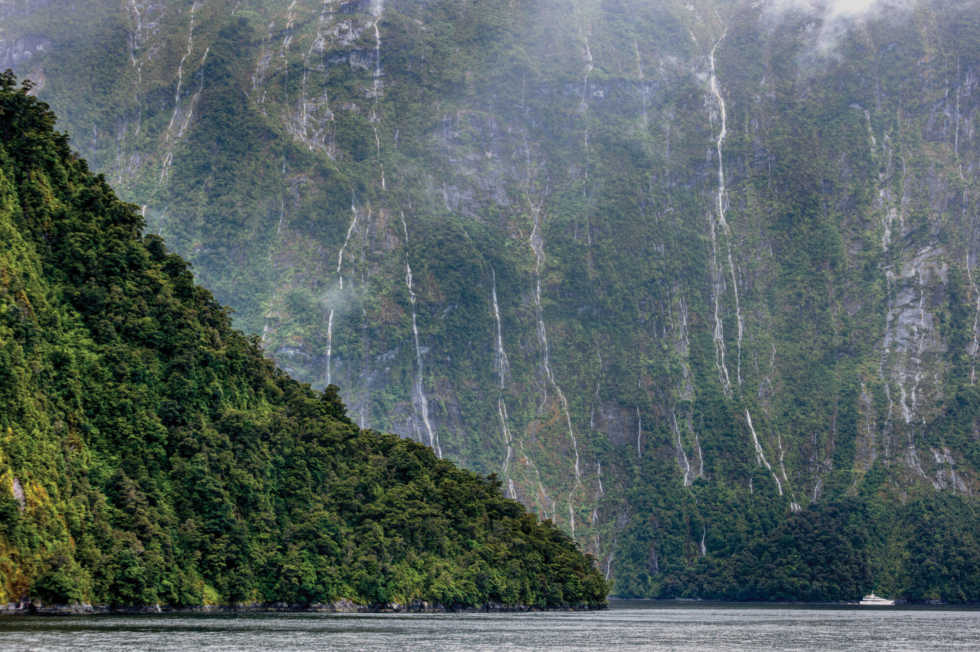
The first time Livvy Harris visited Milford Sound, it was strangely quiet. This was back when New Zealand’s borders were shut, and it was the beginning of winter. Even though the crowds were missing, Harris could easily see the problem.
She parked at the lapping edge of the fiord, the view of mountains filling the windshield of her car. When she got out, mountains were everywhere she turned. They soared from the water across the bay. They crowded the narrow road to the ferry terminal. Their steep faces gleamed in the morning light, as though they’d just been washed.
Before now, she hadn’t fully comprehended what brought so many people here. She’d seen the visitor numbers—she needed them for the model she was building. Thousands of people a day passed through. Almost a million a year. Now, she understood why.
Harris followed the boardwalk to the ferry terminal—a path built partly over the water, because there was barely enough room on land for the road before the rock soared up into the sky again. Well, she thought, I wouldn’t be able to climb up there. At the terminal, she took stock. There really is no other way out, except for the way in.

There, she boarded a cruise boat. The staff had heard about her research, and they were curious. They knew there was a risk of a tsunami racing down the fiord—what more was there to study about it? Was it really very likely? What would happen if one hit?
Harris gazed down the water, over the right shoulder of Mitre Peak, to where the giant wave would come from. She was trying to figure out if anybody would escape it.
[Chapter Break]
This isn’t an outlandish scenario. An earthquake on the Alpine Fault has a coin-flip chance of dislodging a landslide into Milford Sound, which will almost certainly set off a tsunami. We know this because it’s happened at least 30 times before.
Below the deck Harris stood on, beneath the black water, the seabed is coated in layers of debris that used to belong to the mountains. The peaks are still scarred where the rock split and fell.
When part of a mountain topples into a fiord, what happens? Think of Archimedes in the bath.
“If you drop a million tonnes of rock into the water, a million tonnes of water is going to try and get out,” says the University of Canterbury’s Tom Robinson, an expert in disaster risk, especially landslides triggered by earthquakes.
A tsunami isn’t good news anywhere, but a fiord is a particularly bad place to have one. The size of the wave would depend roughly on how far a landslide fell and the depth of the water it struck, and in Milford, a rock avalanche could tumble 1000 metres into water only 300 metres deep. These proportions are not in our favour.
“The ingredients are there for very large waves,” says Jesse Dykstra, the first person to investigate the fiord’s tsunami risk. He moved from Canada to Christchurch in 2006 to study it, spurred on by research from another country with a lot of fiords: Norway (see sidebar).
But to calculate the likelihood of an Alpine Fault earthquake causing a tsunami, he first had to find out when all that debris hit the bottom of the fiord.
[Chapter Break]
Once, Milford Sound was filled up to the top with ice, a solid river carving its way through granite and gneiss. When this glacier melted, there was nothing left to brace the mountains it had been sculpting. Peaks like the Lion were new to the concept of standing up on their own. They started tumbling down, helped along every few centuries by an almighty shake.
This is partly what makes Milford so astonishing, what gives it the sense that it’s both as old as the sun and newly hewn from stone. Rudyard Kipling, author of The Jungle Book, described it to a friend as one of the wonders of the world, placing it alongside the Grand Canyon, Victoria Falls, and the Himalayan peak Kanchenjunga.
Fiordland, as a whole, is a crumbly place. Further south, near Monowai Lake, are the remains of the Green Lake landslide, one of the largest known in the world, which was probably triggered by the Alpine Fault around 15,500 years ago. In 2003, an earthquake in Fiordland set off more than 400 landslides and generated a tsunami in Taiporoporo/Charles Sound that felled trees five metres above the shoreline.

The rate of landslides is increasing globally, especially in mountainous areas: a 2012 study found many had been triggered or exacerbated by extreme weather. Landslides have killed more people in New Zealand than earthquakes, volcanoes and tsunamis put together. And yet, we’ve escaped lightly, mostly because areas such as Fiordland are sparsely populated.
Figuring out when Milford Sound’s glacier melted away makes all the difference to landslide maths. If the glacier vanished 50,000 years ago, for instance, that means tsunamis are a lot less frequent than if the glacier disappeared more recently. Dykstra found that the ice retreated about 17,000 years ago. Combining that with other factors, he determined there was a 44 per cent chance of an Alpine Fault quake causing a landslide tsunami.
The wave would reach Milford Village in anything from seconds to eight minutes, depending on where the landslide began. If a rock avalanche fell from Mitre Peak or the Lion, two mountains known to have had large landslides, people would have less than two minutes to evacuate.
So, when the Alpine Fault goes, and if the fault causes a landslide into the fiord, would anyone in Milford Sound survive?
[Chapter Break]
There are two obvious ways to evacuate, Harris decided: back along the highway, or up a lookout track which ended in a wooden platform overlooking the bay.
She’d seen the lookout track on the map, but it turned out to be difficult to find in real life—it was at the back of the carpark and not clearly signposted. Many people would never notice it, she realised. Even if they did, would they find it in the confusion of an evacuation?
Back home, she refined her model of how people would move to her evacuation spots, based on the dynamics of traffic congestion. She ran several scenarios, factoring in the number of people in the fiord, how fast they would move, the steepness and narrowness of the lookout track, the length of the highway, and whether they started to move as soon as the earthquake began or waited until it had stopped.

On her next visit to the fiord, she sprinted up the lookout track and timed herself, dodging tourists along the way. It was unexpectedly difficult, and she couldn’t match the fastest speed she’d used in her model.
But in the end, speed didn’t really matter. The path was too narrow, and it became too congested when just 19 people were on it; only a handful of people would reach the platform at the top by the time the wave hit.
The highway out was the opposite: it was long and flat, meaning that only fast runners would make it to higher ground in time.
In Harris’s best-case scenario—a winter night, and a wave that took almost eight minutes to reach the village—just over five per cent of people survive. That’s 12 out of about 230 people staying there. On summer days, given the same timeframe, it’s 0.1 per cent, or four people out of about 3700 in the sound. In her worst-case scenario, the wave arrives before the ground has finished shaking. Dykstra calculated that if a landslide hit Deepwater Basin, the shallow bay on the other side of the airstrip, a monster wave would hit the village in seconds. Harris didn’t bother putting that one into her model at all.
[Chapter Break]
You can see the Alpine Fault from space: a straight line running like a spine or a zip up the South Island. It has pushed the Southern Alps 20 kilometres upwards over the past 12 million years, which means that without the Alpine Fault, we’d have no alps, and not much of a South Island. It’s the curse that goes along with all the beauty.
The Alpine Fault is very punctual, like a bell that tolls every 300 years. Last time, in 1717, it broke the earth along a 380-kilometre line in a matter of seconds and shunted the two halves seven or eight metres apart. Any day now, the fault will unzip the island again.
Research published in 2021 updated the likelihood of the fault rupturing in the next 50 years to 75 per cent—it used to be 30 per cent. The quake will most likely be magnitude eight or higher.
Rarely do natural disasters come with this much warning. And so, every few years, emergency planners rehearse what they will do when it hits. In June, they gathered in Wellington to pretend that there had just been a magnitude 8.1 Alpine Fault quake, that around 800 people had been killed and 12,000 injured, and that Queenstown and the West Coast had been severed from the state highway network, cutting off 40,000 people from the rest of the country. Landslides had dammed two major rivers, endangering communities downstream as water accumulated. (The scenario didn’t include a Milford Sound tsunami; planners wanted to focus on other impacts of the fault.)

The Alpine Fault poses threats up and down the South Island, and Milford Sound isn’t the only place that may experience a tsunami. A massive landslide hit Lake Wānaka after glaciers retreated from the area, found a 2015 study, which warned of further landslides and tsunamis following an Alpine Fault quake. The same risk exists in Lake Tekapo; a 2015 report by GNS Science found landslides could cause waves up to 25 metres high. (It’s worth pointing out that an earthquake isn’t necessary for a tsunami to occur. There have been at least 74 tsunamis or big waves in South Island lakes between 1896 and the present day, only half of them caused by seismic activity, the rest by landslides or other factors, according to a Department of Conservation [DOC] report).
Around the country, researchers are attempting to bring future hazards into focus—mostly by looking at the past.
[Chapter Break]
Driving west across the Main Divide, I find myself noticing which peaks are forested and which are grey with scree. Thinking about the land’s propensity to fall on you certainly deprives the alps of some of their beauty.
At Springs Junction, the highway splits west and north. Just before it is Marble Hill, perfectly round, like a boulder in a river, which it used to be. A boulder in a river of ice.
I pitch my tent in a DOC campground which happens to be located right on top of the faultline. I’ll be sleeping on the Pacific plate, I calculate, not the Australian one. A short distance from my tent is a random concrete wall: a knee-high fence that encloses nothing, protects nothing. It’s Evison’s Wall, named for the geophysicist who commissioned it, and it crosses the faultline like a Band-Aid.
The next morning, palaeoseismologist Robert Langridge tells me that when the fault goes, it will snap the wall in two and shunt the halves several metres away from each other. The broken pieces will show exactly how the plates have moved. Frank Evison didn’t live to see this happen, but the chances of it occurring in Langridge’s lifetime are pretty good.
Langridge, a landslide expert, thinks this valley floor used to belong to one of the mountains looming above us. For the past few years, he’s spent summers looking for proof of this along the nearby Maruia River.
Just as palaeontologists look for fossils, palaeoseismologists look for scarps: bits of land where the earth has been cut or eroded to leave a sheer face. Cliffs, river banks, road cuttings: all can be cross-sections of history.

I follow Langridge up the river to a particularly juicy scarp that he’s been investigating for a while now. It is a very tall wall of dirt studded thickly with rocks like fruit in a Christmas cake. He scales it partway, then begins to gently remove layers of crud from its face, using a kind of trowel with a sideways head. “That’s a Japanese rice paddy tool,” he says. “It’s very good for scraping surfaces. Sometimes when [Japanese academics] come to visit they’ll bring a box of them for us as a gift.”
The weather is gloomy, and the mountains across the river have been appearing and disappearing all morning. “When the cloud lifts from there,” says Langridge, surveying the valley from his perch, “you’ll be able to see that there’s a whole huge piece of the face missing, and I think it came right across the valley here about 10,000 years ago.”
Langridge collects a bag full of rocks, which he’ll take home in order to try to figure out how old they are. Does the date of this landslide, for instance, match up with one of the hypothetical past Alpine Fault quakes? Could he add a little more proof to the record?
In some ways, he says, geologists are like crime-scene investigators who’ve turned up thousands of years after the action. Yet they can still pick up clues from the landscape, and they can still make guesses about the future based on what’s happened before.
Jesse Dykstra looked for signs of past tsunamis in Milford Sound, but the land was too steep and ever-changing to have kept any records. It’s hard to know how a wave here would behave, he says, without analysing the precise shape of the fiord. Because fiords are so narrow, they can make tsunamis act strangely, amplifying waves or attenuating them. Imagine water sloshing around in a bathtub: same deal.
This wave-modelling work was out of scope for Dykstra’s study, but he recommended it when his research was published in 2012. The Norwegians had already modelled wave behaviour in their high-risk fiords; it’s yet to happen here.
[Chapter Break]
Last year, before the summer holidays, Tom Robinson got in touch with the company that runs Milford Sound to show them Harris’s research. Her study hadn’t yet been peer-reviewed, but Robinson felt its findings were significant enough to warrant giving the tourism industry a heads-up. We’ve put this through multiple stress tests, he reasoned. Sitting and waiting on this is potentially putting people at risk.
Milford Sound Tourism acts like a mini-council; it runs the village’s wastewater, rubbish and recycling services, maintains the walkways, berths, harbour, and carparks, and holds the concession from DOC to operate all this infrastructure on conservation land.

Its chief executive, Haylee Preston, and a group of local authorities, emergency planners and business owners decided to request further research, including a more comprehensive catalogue of risks. Preston also wrote to all the country’s universities to ask if they had similar research under way. If Milford Sound Tourism was going to create tsunami infrastructure, she reasoned, they should build it in a place that’s definitely not vulnerable to tsunamis, and she wasn’t yet sure where that was. Harris’s study was one piece of evidence; Preston and her colleagues wanted more. “We don’t want to be ad hoc, to do some things and some processes and not others,” she says, “without understanding the full picture.” (If this research is going to take ages, she says, they’ll look at “some practical things that we could be doing now”.)
[sidebar-1]
Preston wants to precisely determine the societal risk of Milford Sound, then ask the government to decide whether that risk level is acceptable. “It shouldn’t be us setting societal risk, and it shouldn’t be DOC, and it shouldn’t be individuals. It needs to be central government setting our risk tolerability levels.”
There are two ways of thinking about risk: there’s the risk to a person, and then there’s the risk to a society. For Milford Sound, those risks look completely different. Most people visit for four to six hours; the likelihood of an earthquake, landslide and tsunami happening during that time interval is very low.
At the same time, there are people in Milford Sound every day, and one of those groups is almost certainly going to be very unlucky. “So, for individuals, the chance that it happens to you is pretty limited,” says Robinson. “The chance that it happens to New Zealand is pretty high.”
Still, Robinson is circumspect, careful to point out that he’s not suggesting Milford Sound be closed. He’s cautious about shunting tourists to another location where the risks aren’t lower, just less well known. Milford, he says, is the study of one landslide; the Alpine Fault will trigger tens of thousands of landslides across the entire South Island.
“I think the Alpine Fault’s a weird one in that it seems to get worse the more you look at it,” says Robinson. “But that’s because we have the least ignorance about it. We’ve been working on it for such a long time. So it’s kind of a catch-22 of the more you know, the scarier it is.”
Still, there’s an important question to ask: “Are we prepared to tolerate the fact that we have so many people there every single day,” he says, “and therefore the chance of a big loss is quite high?”
It’s a hard question to contemplate, says psychosocial scientist Lauren Vinnell. Our brains get in the way when we think about a risk this big.
For some people, the potential consequences are so terrible that they’ll stay away—the tiny chance of a tsunami happening is irrelevant to them (that’s called likelihood discounting).
For most people, the fact there hasn’t been a major landslide tsunami in New Zealand in recorded history causes us to unconsciously discount the risk (in other words, we have too much temporal and social distance from it).
Vinnell, a lecturer at the Joint Centre for Disaster Research at Massey University, is studying how well people understand landslide risks. “So, for example, there’s this perception that a landslide is, like, one and done. Once the land has slid, that’s it, there’s not going to be any more. Which is simply not true.”
Similarly, earthquakes can start a chain reaction of events that we tend to forget about. “We know that when people think about earthquakes, they tend to think about the ground shaking and maybe buildings collapsing, but they’re not necessarily thinking about the secondary impacts, like landslides or liquefaction.”
[Chapter Break]
In April, Jesse Dykstra contributed to a paper comparing Milford Sound’s risk with that of Whakaari/White Island. The risk to individuals of visiting Whakaari, he says, probably fell within internationally acceptable limits. The key was the societal risk. “This is where New Zealand got it badly wrong,” he says. “The societal risk was probably orders of magnitude too high.”
His paper, which he co-wrote with Tim Davies, suggests the societal risk of Milford Sound is even higher. The only way of reducing it is to limit the number of visitors.
Dykstra is now a geotechnical advisor at Christchurch City Council. He lived through the Christchurch earthquakes, spent time studying the Kaikōura one, and now assesses unstable land in Banks Peninsula. He’s possibly spent more time contemplating the possibility of a Milford Sound tsunami than anyone else I’ve spoken to. And he assesses risk for a living. Would he go back to Milford as a tourist?
“Yeah, absolutely. And I’d take my kids there. Definitely. Because your individual risk is minuscule. You’re probably as likely to get hit by lightning. It’s just because there’s so many people there all the time that, when it happens, it’s going to be a disaster.” But for one family, visiting for half a day? “I wouldn’t hesitate to go there again.”