Tararuas
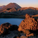
In our Wellington house, one window frames a view of the Tararua Range. During summer, when heat haze renders the hills as indistinct as an impressionist’s painting, they don’t appear substantial—just a distant blue ridge, a smudge sometimes merging with the sky.

On a winter’s day, however, when a southerly has cleared the air and breathed its icy residue on them, the Tararuas look like real mountains. Snow lends them a lofty grandeur that belies their modest stature. Then, I can clearly make out the line of the Southern Crossing, a three-day tramp that takes a dog’s-leg route over bush and tussock ridges in the southern part of Tararua Forest Park.
The Tararua Range begins at the northern limit of the Rimutaka Range—where State Highway 2 cuts a meandering path between Wellington and Wairarapa—and stretches north to the Manawatu Gorge. Essentially, it is a 100 km segment of the North Island’s 500 km-long backbone, which extends from Turakirae Head, south of Wellington Harbour, right up to East Cape. As well as the Tararua mountains, this spine includes the Rimutaka, Ruahine and Kaweka Ranges, the Kaimanawa Mountains, and the Huiarau and Raukumara Ranges. I like to think of these as New Zealand’s Northern Alps.
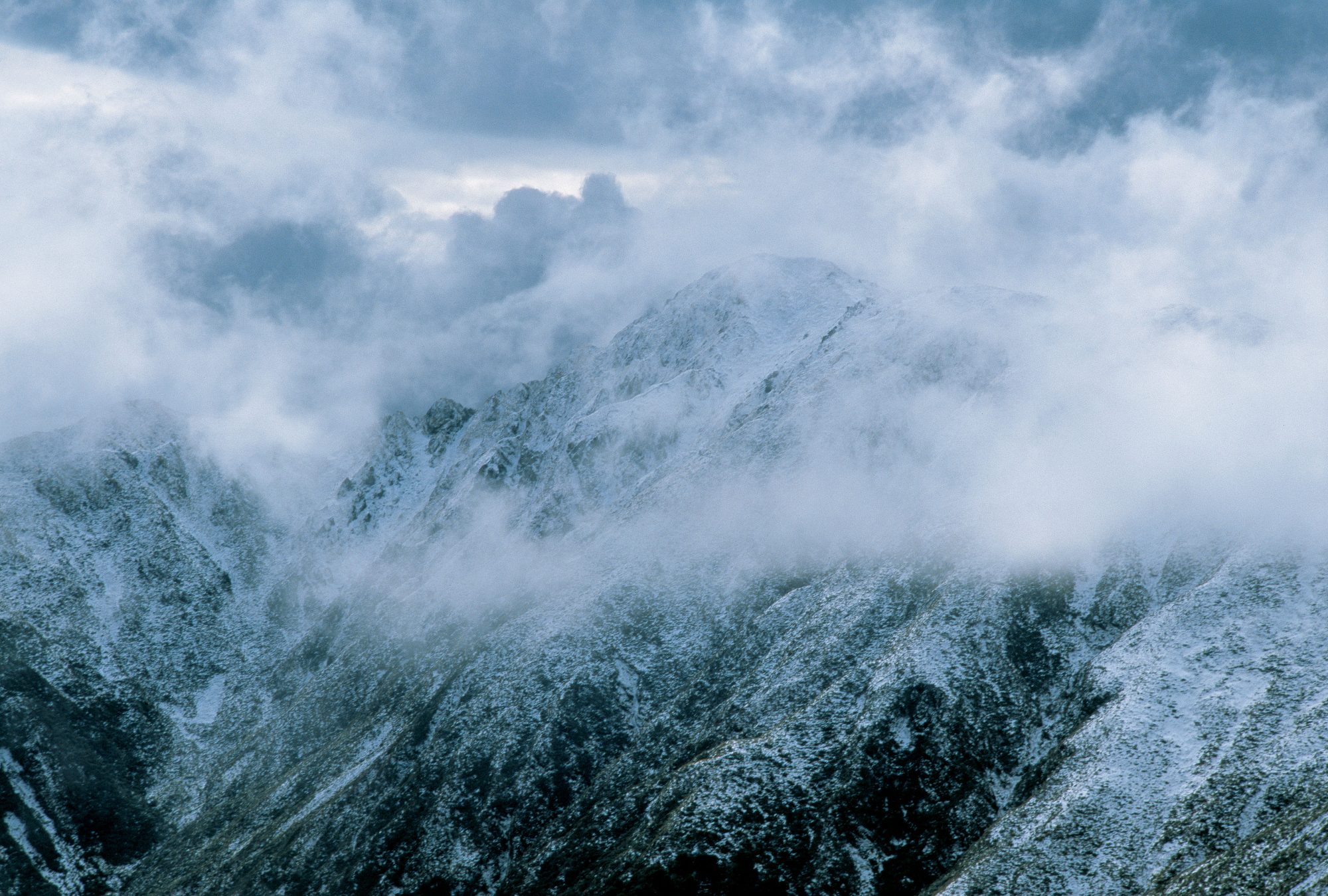
But often I can’t see the Tararuas. Even when Wellington is fine, a heavy bank of cloud often envelops them like a grey fungus. In his book Waking to the Hills (1985), tramper Geoff Spearpoint calls them “the traditional home of rain and fog”, and it’s hard to argue with that.
Savage weather batters the range to such an extent that even those familiar with the higher and harder mountains of the Southern Alps have sometimes underestimated it. As Spearpoint notes, the problem with the Tararuas is their exposure to weather from all directions, particularly the fierce winds channelled through Cook Strait. “Southerlies bring the snow and freeze them; westerlies bring the rain and wet them; northerlies blow until it is a marvel there is anything left.”
In January 2005, over a 12 hour period, some 230 mm of rain poured out of the sky into the Otaki catchment. The deluge resulted in flash flooding that wiped out a 46 year-old footbridge at Otaki Forks and gouged out many side creeks to bedrock. On the nearby Southern Crossing, rescuers waited three days for a break in the weather while they nursed a solo tramper suffering from hypothermia. Eventually they gave up waiting and carried her down to where a helicopter managed to slip in under the cloud base.
Such events are not out of the ordinary in the Tararuas. While Westland undoubtedly receives more rainfall, and other places more wind, the Tararuas have a propensity to attract fog. On average, the tops are clear for just 80 days a year, or about one day in five. One early Tararua tramper, Leslie Adkin, once remarked, “Tararuas! thy other name is mystery.” Those of more cynical mind might shorten this to “Tararuas! thy other name is mist.”
In his widely read and oft-quoted book Land Uplifted High (1952), mountaineer John Pascoe famously penned a waspish portrait of the Tararuas that for over 50 years has both drawn attention to the range and poisoned its image: For sheer miserable monotony of contour, rigour of weather, and bleakness of outlook, it is hard to beat the Tararuas. They are to Wellington trampers what oatmeal is to Scottish people; dull solid fare which gives them staple virtues. It is no defence for the Tararuas to say that they have their fine days. As with shrews, their niceness is unpredictable.
No wonder the Tararuas’ reputation flies like a tattered flag too long exposed to wind and rain.

The Tararua mountains proved shy about revealing their charms to me during my first forays there in the late 1980s. Having tramped in the more equable climes of the Hawke’s Bay mountain ranges, I was astonished to discover that, in the Tararuas, rain could actually blow upwards. A party of five of us, students from Massey University, emerged above the forest one bleak Tararua day to find the wind beating uphill, skimming over the leatherwood and pushing rain under our coat flaps.
It was also in the Tararuas that I first experienced wind powerful enough to shift a fully laden tramper. On the Jumbo–Holdsworth track (a popular tramp inland from Masterton), gusts repeatedly blew me off my boots, often sideways into speargrass, while on yet another attempt at the same route, despite perfectly clear skies, the wind forced me and my fellow trampers off the tops. It was impossible to stride without one leg being blown into the other, and all our movements assumed a drunken quality. While comical, our progress proved so slow we had to retreat to a nearby hut.
During four years in Palmerston North I made 16 trips into the Tararuas. Rain, mist or wind—often all three featured on 11 of these visits. I could count myself lucky for getting even that much fine weather. In A Tramper’s Journey (2004), Mark Pickering relates the story of one unfortunate who, despite 13 tramps over the Southern Crossing, has yet to see the view from Mt Hector, the highest point on the track.
As many years as not, the Tararua Range claims lives— 55 between 1900 and 2003. The majority of deaths occur by drowning, with hypothermia a significant second. Some die because they are underequipped or ill-experienced. Others, like Ralph Wood, are simply beaten by the weather. Near Waiopehu, in the north-western part of the park, a cross marks where Wood died in 1936. He succumbed to exposure, as hypothermia was then called, during a cyclonic storm that is still remembered by old Tararua trampers. It blew the nearby Waiopehu Hut into the valley below. Members of a party caught in the storm were lucky not to be killed by uprooted trees. One of them remarked:
“A peculiar feature was the twisting force of the wind; tops of trees were visibly screwed round until they broke off leaving a shattered stump.”
The storm flattened sections of forest on Oriwa Ridge. Such was the devastation that it was more than 20 years before travel improved. An account in one guidebook described “high aerial traverses over jumbles of logs, alternating with undignified muddy grovelling beneath them”.

Given so inhospitable—and sometimes deadly—a climate, even by New Zealand mountain standards, you might ask why anyone would willingly venture into the Tararuas. Yet many stalwart trampers, particularly Wellingtonians, defend them with fervour. Perhaps used to upholding the weather-beaten reputation of their city, residents of the capital extend their loyalty to the local mountains.
Proximity certainly plays a role in attracting trampers. To those in Wellington, Wairarapa, Manawatu and Horowhenua, the Tararua Range is home ground. Every year, tens of thousands of locals walk the dense network of tracks that connects the valleys and ridges of the park like a spider’s web, while many more enjoy picnic areas, camping spots, swimming holes and short walks on its fringes.
Yet the Tararuas’ closeness to densely populated areas can’t fully explain their popularity. Mountaineer Paul Powell perhaps best summed up their appeal in his book Just Where Do You Think You’ve Been? (1970):
In fine weather the Tararua Ranges can be beautiful, a great pattern of bush ridges and spurs with deep clefts of river and gorge where the light flashes silver in the early morning sun and the undulating tops run tussocked and clear for sixty miles. They have a tranquillity, a friendliness, that lure you ever back again to wander their limitless variations. The balance between valley, ridge and summit is quite perfect for there are no grim rock turrets and hanging snowfields to be footstools for ambition. Anyone of commonsense and fitness can go to them; they are to those who love them places of content.
[Chapter break]
After my initial association with the Tararua Range in the late 1980s, I shifted to bigger mountains: the Southern Alps, the Andes, the Rockies, the Himalayas. High peaks, large snowfields and glaciers are seductive, and can blind you to the more subtle charms of less boastful uplands. I didn’t return to the Tararuas for eight years.
However, a move to Wellington in 1998 encouraged me to renew my acquaintance with the range. The flexibility of self-employment allowed me to plan Tararua tramps around reasonable weather, and in so doing I discovered a place that has as much charm, as much diversity and as much beauty as any mountain range in the country.
For a start, the Tararua Range is positioned in the centre of New Zealand, from where views extend both to the South Island and as far north as Taranaki. On breathless evenings, camped on the Tararua tops, I’ve had views of both the Tasman Sea and Pacific Ocean. Ridge after tawny ridge line up towards the upturned hull of Kapiti Island, floating off the coast. Sometimes Mt Taranaki floats like an island too, borne upon the distant haze. Beyond Cook Strait, the ridges of the Marlborough Sounds to the west and the Kaikoura Ranges to the south rise out of the sea.
On a good evening the subtle play of light on the complex folds of the land is as exquisite in the Tararuas as anywhere I’ve been. The gold of the tussock; the khaki sub-alpine scrub; the darker, more sombre green of the forest. Then, tiny jewels among the tussocks, the delicate whites of mountain flowers: foxgloves, eyebrights and gentians. A journalist writing in the 1920s described the Tararuas thus: “It is in their changing colour tones that perhaps they most appeal: it is almost impossible to get them exactly alike on two separate occasions; and like an attractive woman, every mood but opens out fresh charms.”
There’s a pleasing diversity of forests in the Tararuas, too. Complex, dense podocarp-hardwood forests in the west enjoy every drop of the 5 m or so of rain that falls on them annually. In the east are more open and drier beech forests, often with a spacious understorey. Arguably the most singular feature of the Tararua flora is the silver-beech forest that invariably dominates the bush edge. Here trunks and branches are twisted at arthritic angles by the combined effects of altitude and weather. The trees’ moss-draped, intertwined limbs filter the mist, and in the wind they creak and groan.
Perhaps the most appealing attribute of the Tararuas, however, is simply the range of tramping options on offer. A labyrinth of back-country tracks gives trampers as wide a choice as they are likely to find anywhere in New Zealand, while, with 50-odd places to shelter for the night, accommodation varies from two-bunk bivvies not much larger than oversized kennels to palatial 40-bunk huts complete with gas cooking and heating facilities.
[Chapter break]
On a map of the Tararuas you’ll notice a name for virtually every creek, ridge, knoll and hillock. The density of names, perhaps unmatched by any mountain area of comparable size in the country, reflects the fact that every section of the tops and every major river can be—and has been—traversed. Although places such as the head of the Park Valley have experienced glaciation in the past, today there are no glaciers to negotiate and no tops more difficult than the steep but manageable Broken Axe Pinnacles. And despite an abundance of challenging gorges, not one of the major rivers features an impassable waterfall.
One of the great Tararua adventures is to tramp into the headwaters of a river, exchange boots for a wet suit, blow up a tyre tube and let the current flush you out of the mountains. Virtually all major rivers in the Tararuas—the Otaki, Waingawa, Tauherenikau, Ruamahanga, Mangahao and Waiohine—are suitable for this. No other mountain region in the country offers such a collection of rivers so suited to tubing.
The simple fun of tubing, however, belies how difficult early trampers found these gorges. In one epic, in 1933, a party of four trampers—Morva Williams, Bill Sutch, Eric Hill and Bert O’Keefe—were exploring routes across the northern tops. On their second day they found themselves negotiating the Broken Axe Pinnacles, and O’Keefe slipped on a steep slope. In a nasty 30 m fall, he cut his face badly and was knocked unconsciousness for an hour. Appalling weather prevented the trampers from continuing over the tops, and they dropped into the head of the Waiohine Valley, the longest and most difficult of the Tararua gorges. Its full length had not been traversed before.

Here, flooding forced the party to stay on the more difficult true right of the river, where they endured four more days of arduous travel. O’Keefe later recorded:
We would be sidling to save climbing and would strike a sheer rock face or shingle slides which couldn’t be crossed. This meant retracing our steps to choose a more favourable route or gruelling climbing under fallen trees. Again and again we would ascend 1000 feet or so and have to descend again immediately because of steep depressions between the ridges. They were hard times.
After bad weather foiled another attempt on the tops, the trampers were once more forced into the Waiohine Valley. By this stage all their food was gone; remarkably, they’d managed to eke out two days’ supply over nine.
Weather hampered a huge search for the missing trampers involving some 200 people. Given the inadequate maps that existed at the time, the missing trampers unknowingly slipped past Sayers Hut, tucked out of sight in the bush in the lower Waiohine, where searchers would have been able to provide food and warmth. Finally, after a further two days’ roaming the wilderness, they staggered, exhausted, onto farmland. Altogether they’d spent two weeks in the most remote and difficult part of the Tararua Range.
[Chapter break]
It’s surprising how a little knowledge of a place can enhance one’s appreciation of it. My enjoyment of the Tararuas increased by an order of magnitude after I had bought a copy of a book which told stories like the one above. Tararua: The Story of a Mountain Range (1994), written and published by Wellington historian Chris Maclean, is the definitive book on this particular place. In the introduction Maclean writes: “As I became more familiar with Tararua history, I was struck by the paradox that this magnificent alpine area should have such a poor image and at the same time give so much pleasure to so many people.”
Part of his aim in writing the book was to restore some of the Tararuas’ mana, which had been suffering ever since Pascoe had likened them to oatmeal. Maclean highlights just what a crucial role the Tararuas have played in the development of outdoor recreation in New Zealand, from spawning the country’s first tramping club and tramping-club huts to becoming the first forest park.
In the early 1900s the Tararuas attracted explorers and trampers, some of whom in 1919 formed the Tararua Tramping Club. This was the first in what became an explosion of outdoor clubs during the 1920s and 30s. Club members built tracks and huts, shared their knowledge of bushcraft and stimulated an interest in outdoor recreation that is now part of the New Zealand psyche and tradition. Many recall this period of outdoor activity as “the Golden Years”.
As Maclean wrote: “The formation of the Tararua Tramping Club in 1919 ushered in a new era of organised recreation, and its activities and structure became a model that many later clubs emulated.” Club founders Willie Field and Fred Vosseler were already experienced Tararua trampers, having been on numerous private forays into the range. But both had a vision that tramping could be encouraged more widely by more formal organisation. They also wanted to stimulate participation in winter sports, and to preserve the flora and fauna of the Tararua Range.

At first the Wellington-based club restricted its activity to the more local hills, mainly to build up the fitness and experience of its members. Then, in 1921, a group of 60 made a more strenuous tramp up Mt Kapakapanui, a western outlier of the Tararua range. By 1923 the club boasted more than 300 members.
While women were at first excluded from the harder tramps, members of the fairer sex soon augmented the ranks of the growing club. According to Maclean, Vosseler’s wife, May, played an important role in encouraging women trampers, but found that “One of my greatest troubles, unbelievable in those enlightened days, was in getting the ladies to modernise their clothes—stout boots and strides instead of high heels and flimsy apparel.”
One of the great advantages of belonging to a tramping club was the availability of transport. Flat-bed trucks provided the means to usher a large number of trampers—and their packs—into the hills. As Maclean notes, “Although punctures and breakdowns were common and dust from the unsealed roads made travel tiresome, the camaraderie of club life was reinforced by such journeys.”
More clubs were formed in the 1920s: the Victoria College (later University) Tramping Club in 1921 and the Hutt Valley Tramping Club in 1923. In Levin the Levin Waiopehu Tramping Club was established in 1927, and in Palmerston North, the Massey Agricultural College spawned a club two years later. These days there are now seven active tramping clubs in Wellington alone; some, like the Tararua Tramping Club, have hundreds of members and run several trips every weekend.
[Chapter break]
While the advent of tramping clubs meant better organisation and the sharing of bushcraft and route information, it didn’t make club members immune to the savage Tararua weather. In 1922, the first official Tararua Tramping Club crossing of the Tararua Range—over the Southern Crossing—was marred by a death.
The original Southern Crossing began at Otaki Forks, inland from the township of Otaki, and climbed bush ridges up to the tussock tops of Mt Hector, where it curled around exposed knolls to Mt Alpha. From there it descended to the Tauherenikau Valley before crossing more bush ridges and ending near Greytown. Before the formation of the Tararua Tramping Club, a group that called itself the Mt Hector Track Committee had encouraged tourists over the crossing. With funding from the Tourist Department, its members had cut the track and built three huts: one near Mt Alpha (1915), a second beside the Tauherenikau River (1917), and a third on the western side of the range called Te Moemoe (1919). But there was no shelter on the tops.
Harold Freeman was one of a group of 12 Tararua Tramping Club members to attempt the Southern Crossing in January 1922. Two turned back early on, but the remaining 10 trampers, after crossing Mt Hector, found themselves pushing into worsening weather. Without adequate clothing, some began to suffer in the cruel southerly. Eventually, Freeman “got to the stage where he couldn’t go any further”. Despite the help of another tramping party, who carried him to Alpha Hut, he died in his bunk from the effects of exposure. “The death of Harold Freeman was both a terrible shock to the fledgling Tararua Club, and a sharp lesson,” notes Maclean.

Soon after, in June 1922, another tramper succumbed to the treacherous Tararua weather. Despite surviving five nights alone in the snow and wet before being rescued, E. Kime died—like Freeman—in Alpha Hut. However, both tragedies were to have positive outcomes for tramping.
Now that the need for more shelter in the mountains had been forcefully brought home, the Tararua Tramping Club started to plan the first tramping-club huts in New Zealand. First to be built, in September 1922 near Mt Hector, was a small emergency shelter, soon dubbed the Hector Dogbox. Another vicious southerly blew this to pieces in 1929.
In the interim, however, the club had decided to build a second hut, above Otaki Forks, to replace the poorly sited and deteriorating Te Moemoe Hut. In 1924, with a generous grant from co-founder Willie Field, the club employed master bushman Joe Gibbs to carry out the construction. He and partner Joe Fisk laboured for 161 days, using timber pit-sawn on site. Appropriately the new building became known as Field Hut. There are certainly many older back-country huts, but Field Hut is the oldest surviving hut in the country built specifically by a tramping club for trampers.
Whilst the 1920s and 30s saw much activity in the Tararuas, with more huts built, tracks cut and clubs formed, World War II reduced the number of people able to enjoy the mountains. By the 1950s, however, tramping was enjoying a fresh boom, and the Tararuas were set to make history once again with the creation of the coun¬try’s first “state forest park”.
In 1936, with the centenary of Wellington approaching, some trampers had proposed national park status for the Tararuas. Others had been opposed, one commenting: “The point wants making that these ‘National Parks’ are run with an eye on the tourist traffic and would be much more suitably named ‘Tourist Parks’.” Although the Wellington Centennial Committee had turned down the proposal, in 1952 the idea of a Tararua National Park re¬surfaced. However, the Forest Service resisted this idea as it would mean losing a significant part of its estate to Lands and Survey. Instead, it decided to propose an alter¬native type of park—a “state forest park”.
[Chapter break]
From the 1920s to 1987, two separate government departments managed those parts of New Zealand’s orests and mountains owned by the Crown. The Department of Lands and Survey managed scenic reserves and, later, national parks, while the New Zealand Forest Service managed state forests. The two organisations had contrasting philosophies and approaches to management, and at times a degree of rivalry existed between them.
Lands and Survey espoused a philosophy of preservation—areas under its aegis were, as far as possible, to be kept in a natural, pristine state. Dogs were not allowed, all pests were to be destroyed, and extractive activities such as mining and milling were excluded. In contrast, the Forest Service adopted a broader “multiple use” philosophy, resulting in a complex arrangement of sometimes conflicting uses: while water-catchment protection was central to most state forests, timber production was the prime focus in others, and recreation, though not encouraged, was often allowed. National parks and scenic reserves were open to the public, but, in theory at least, anyone entering a state forest as late as 1965 needed a permit.

for 23 and hypothermia for 14. There has also been one murder and an accident where a soldier blew himself up with a hand grenade during World War II. Before helicopters revolution- ised search and rescue from the 1960s onwards, tramping clubs performed this servic
The idea came largely from Forest Service manager Priestly Thomson, then based in Wellington. Thomson was an active tramper and mountaineer, and in 1934 had, with John Pascoe, made the first of ascent of Mt Evans, at that time the highest unclimbed peak in the Southern Alps. To forge better links between the tramping community and the Forest Service, he joined the Tararua Tramping Club. In the Tararuas he wanted to expand the Forest Service’s role to include the promotion of outdoor recreation, and to experiment with an alternative type of park that would complement the country’s rapidly growing number of national parks. The ‘state forest park’ system could meet the public’s growing desire for outdoor recreation while at the same time maintaining the Forest Service’s empire. In 1954 the various state forests of the Tararua Range were combined into Tararua State Forest Park—the country’s first.
After a 10-year trial in the Tararuas, the forest park concept proved popular enough with the public for the Forest Service to expand the number of parks, eventually to 21, stretching the length and breadth of the country. As well as the 117,000 ha Tararua State Forest Park, they included other substantial areas such as Victoria, Northwest Nelson, Ruahine, Raukumara, and Craigieburn. In their heyday during the 1970s, the Forest Service made large efforts to encourage recreation in these parks, by developing a range of recreation facilities, including road-end picnic and camping spots.
Federated Mountain Clubs pressured the Forest Service into allowing public input into management of the parks through bodies called Forest Park Advisory Committees. Usually these consisted of a number of carefully selected people, some from tramping clubs, who had a strong interest in the park.
[Chapter break]
Tramper John Rundle, a life member of the Hutt Valley Tramping Club, served on the Tararua Forest Park Advisory Committee for some 10 years in the 1960s and 70s. He started tramping in the Tararuas as a teenager in the early 1950s, at the end of the era which saw huge parties—sometimes as many as 70 or 80 walkers—head for the hills. Few people had cars, so tramping club outings were organised by the busload. “There might be one small fit party, and another larger medium party and a yet larger easy trip.
“Most of the people you struck were from clubs. There was a bit of rivalry between them—at the end of the weekend there would be a tremendous dash down to the road end to try and beat trampers from other clubs.”
Rundle also remembers large weekend work parties building huts, cutting tracks and generally doing their bit for outdoor recreation. By the late 1950s and early 1960s, however, Tararua tramping was starting to change. More people were acquiring their own cars, and thus the means to access a wider range of road ends, while the Forest Service was building numerous huts for deer cullers, particularly in remoter parts of the range previously devoid of shelter. In just two years, 1960–62, the Forest Service erected 10 huts, significantly increasing the number in the park. It also took over all track work, previously the domain of tramping clubs.
While the extra huts and tracks undoubtedly made for greater convenience and accessibility, Rundle and others were angered by some of the changes. “It was very sad, because it was the beginning of the killing of the volunteer work ethic. The whole feeling [in those days] was that when you built a hut, or cut a track, you were doing it for everyone.”

Rundle was also one of a number of trampers who lamented the loss of wildness in the Tararua interior brought about by the new boom in facilities. On the advisory committee he argued “that a lightly marked spur would [have been] quite adequate for cullers. But they [the Forest Service] cut a great wide swathe, which would last for a long time. I wanted to have the opportunity to walk along a ridge with no track, using my own skill—or lack of skill—with a map and compass. And if I walked off the ridge and ended up in the valley, so what? It was all part of the experience. There were plenty of tracks for those who wanted them without putting a track on every spur and ridge.”
Disillusioned by what he saw as a lack of knowledge among some of his fellow committee members (“most hadn’t been beyond the road end”), Rundle put together a collection of photographs showing off the various features of the park. The result was the first photographic book on the range, called simply The Tararua Book (1981). It’s a wonderful record of what tramping was like during Rundle’s era, and a reminder that even in the mountains nothing stays the same.
Better tracks perhaps reduced the challenge of tramping for some, but others saw new opportunities. Speed tramping had been popular amongst Tararua devotees since the 1930s, but enthusiasm climaxed in the 1960s. One of the biggest challenges for a fit Tararua tramper in the early years of the decade was a Shormann–Kaitoke, or S–K. This was a mad dash along virtually the entire length of the range, with the aim of completing it in a weekend.
Graeme Dingle, who began his outdoor career in the Tararuas, described the challenge thus: “The journey required its suitors to climb and descend a total of about 14,000 m and battle subalpine scrub, tangled bush, jagged ridges, biting cold or parching heat—the usual Tararua cocktail.”
After John Tristram and Peter Daniels completed an S–K over a weekend in 1963, the race was on to finish one in 24 hours. Dingle, then a lanky 20-year-old with far too much energy, decided to have a crack at it in 1964, and finally succeeded the following year. He went so hard that at times he hallucinated: “in one place I saw a bear dashing around the hillside, and it even growled at me”. But not even bears could stop Dingle from completing his amazing feat of endurance. He pulled in at Kaitoke after 18 hours and 30 minutes. The length of the Tararua Range had been reduced to a single day’s effort.
[Chapter beak]
Wayne Boness, of the Department of Conservation in Waikanae, is someone who has witnessed the changing trends of outdoor recreation in Tararua Forest Park. He manages all the recreation facilities on the western side of the range, and enjoys hunting and fishing there in his own time. His association with the Tararuas goes back to the early 1980s, when he worked there as a Forest Service trainee.
When the Forest Service disbanded in 1987, Boness was absorbed into the new Department of Conservation (DoC) and found himself working at Otaki Forks. On the rivalry between DoC’s two parent organisations, he says, “There was always an ‘us and them’ mentality.
“National parks were probably seen to be the symbol of the New Zealand back country, kept in pristine state. However, I think a lot of people appreciated forest parks because they didn’t have as many regulations as the national parks. They were somewhere you could undertake recreational activities without a lot of constraints—you can take your dog, for example. That’s important for a lot of people, especially solo trampers.”

After a period of high popularity (and high rates of vandalism) in the late 1980s, Tararua Forest Park saw a slight decline in usage in the 1990s. But, Boness says, visitors are on the increase again. “There is a real cross-section of people using the park now. Schools and local college tramping groups are increasingly using the area. Family groups too. Probably the majority don’t belong to clubs any more. Retired people are using the park during the week. Campers have come back too—the 2003–04 season was our busiest at Otaki Forks yet. It’s a real family environment—those sorts of places are just as important as the interior of the park.
“Getting that balance of facilities right is the tricky thing. We don’t own the park, we are only managing it on behalf of New Zealanders. Every user group has got their own wants. Our job is to try and balance all the wants so the majority of people are happy.”
Making changes to huts or places that have a long history of club involvement is a balancing act, too. In the early 1990s, DoC had plans to demolish Field Hut, despite its historic significance. But partly as a result of a backlash from the tramping community and partly due to a growing recognition of the heritage value of old huts, DoC decided to restore it. Boness says, “We underwent quite a process with Field, in consultation with the Tararua Tramping Club, trying to upgrade it but keeping that historical flavour.”
Another example of club involvement is the new Waiopehu Hut, built on a ridge in the western part of the park with superb views over Levin and the Horowhenua. It wasn’t one of the department’s plans, but the Levin Waiopehu Tramping Club came up with the idea to celebrate their 75th anniversary. DoC and the club worked together on the project, and the hut was opened in 2002.
[Chapter break]
One of the biggest controversies over a facility in the Tararuas in recent years centred around the famous Tararua Peaks ladder. In the late 1920s, one of the great challenges facing Tararua trampers was a rugged area of the main range which had yet to be traversed. The crux of the route was a deep notch between two sharp knolls—Tuiti and Tunui—known collectively as the Tararua Peaks.
The difficulty of the route defeated one attempt at a traverse in 1928, but later that year another tramping party using a rope and a wire cable managed to negotiate a way round. The cable was left in place and served other trampers for a number of years. Eventually it was replaced by chains, and later a chain ladder was installed to allow easier passage.
I well remember my first trip down the infamous ladder in 1989. Clag hung heavily on the peaks, and Tunui looked formidable under its cap of cloud, but we were thankful enough that conditions were moderately calm. There was even a certain exhilaration as we descended the aluminium rungs, which were so tight against the rock face there was little space for anything more than a toe hold. On reaching the bottom, we felt we’d come through a classic Tararua tramping experience.
By 2002, however, the ladder was suffering from over 20 years’ use in a damp and exposed environment. DoC proposed a replacement, but the initial design horrified some in the tramping community.

The problem, Boness tells me, is that new building codes required a landing for every 6 m of ladder. As the ladder had to be 22 m long, a minimum of three landings was needed, plus a safety cage to boot. Many clubs thought the planned construction grossly overdesigned and that, if installed, it would severely diminish the Tararua Peaks experience. In the end, Boness negotiated a compromise with the local council after explaining the concerns of the tramping community.
In April 2002, a new 800 kg galvanised-steel ladder was installed in three sections, “like a big Meccano set,” says Boness. “There was some pretty precise flying to get it in there on a 30-metre strop. It took 14 hours.”
By coincidence, the old chain ladder had, just the month before, been struck and damaged by lightning. A lightning conductor rod situated above the new ladder will, it is hoped, ward off any future meteorological attacks.
While Tararua trampers of old may look upon some of the modern huts as luxurious, and the new ladder as an example of state cosseting, compared with what they used to know, I believe each generation must define its own approach to experiencing the mountains. I’ve no doubt, too, that people will continue to find fresh challenges in the Tararua Range. There are still plenty of places where dedicated trampers can seek adventure and wilderness, but now there are also more opportunities for families and those with less experience. Clubs will continue to play an important role, even if more people now tramp privately.
Certainly the Tararua weather will continue to take its toll and to dampen the reputation of the place. But those who have endured hardship there appreciate the lessons such an accessible place can provide, and often count themselves as Tararua converts. If they sound a little defensive about the weather, well, that’s because they know that on a good day it’s hard to beat the Tararuas.