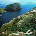
Balleny Islands; End of the line.
Confrontations between Japanese whalers and anti-whaling protesters in Antarctica’s Ross Sea have put the Balleny Islands in the news lately. It is a spotlight to which they are unaccustomed. Fewer than 30 landings have been made on these remotest islands in the 168 years since they were discovered. These are not the kind of islands on which celebrity Survivor television is made (unfortunately). Far, far to the south of our subantarctic islands, they constitute 400 square kilometres of rock and ice cocooned in gales, freezing ocean and icebergs.
With ice all around, three scientists from the 2006 Balleny Islands expedition became the first people ever to dive in the astonishingly bleak Balleny Islands. Above water, the Ballenys are just ice and rock, too far south for any plants, even grasses. Awed by the amount of life found under the water, marine ecologist Rebecca McLeod explains the sensations of that first dive.
“The first thing that struck me, well apart from the pain associated with plunging into –1oC water, were the colours. On land the Ballenys are a wild mass of black and white, but as we descended down the anchor line, our torches showed a world of intense colour.”
The Balleny Islands lie over 2000 kilometres south of New Zealand, a little to the north-west of the mouth of the Ross Sea and only a couple of hundred kilometres off the coast of Antarctica. The chain is oriented north-west to south-east between 66o 15’S–67o 10’S, and 162o 15’E–164o 45’E. Claimed by New Zealand as part of the Ross Dependency, the area is governed through the Antarctic Treaty System.

The Ross Sea is one of the most biologically productive regions in the Southern Ocean and has an estimated annual production four times higher than the global ocean average. Initial research on the waters surrounding the Balleny Islands suggests that the region may be a particularly important part of the larger Ross Sea ecosystem—an ecological hot-spot.
Since 2000, New Zealand has stated its intention to propose a high-seas Marine Protected Area (MPA) that includes the Balleny Islands and the waters around them. The archipelago straddles the Antarctic Circle and contains several habitats which are representative of the Antarctic region, from the terrestrial and coastal zone of the islands to the marginal ice zone and seamounts.
Although conservation and scientific study are identified in the Treaty and the Convention for the Conservation of Antarctic Marine Living Resources (CCAMLR), New Zealand’s quest to establish the Balleny Islands as the Antarctic’s first high-seas MPA involves several challenges.
“The logistics in trying to establish an MPA have been a challenge. Because the Antarctic Treaty and CCAMLR overlap in some ways and don’t clearly identify authority in others, it’s been hard for MPA proposals to gain traction,” says Ben Sharp, a consultant to the Ministry of Fisheries. “Plus, because the Balleny Islands are incredibly isolated, building a scientific case about the need for their protection has been an arduous undertaking.”
Despite limited scientific evidence, however, scientists who have ventured into the area have found signs of a biological treasure trove, including the discovery of undescribed stylasterine corals, anemones, polychaetes and bryozoans and that’s just some of the larger bottom-dwelling invertebrates.

The area also appears to be a nursery both on land and in the sea. Evidence indicates that the waters are essential habitat for both juvenile toothfish and krill. As the only islands at that latitude for thousands of kilometres in either direction, the 160-kilometre chain of islands provides resting and breeding habitat for a number of seabird species and three seal species. The region is also the site of one of only four deep-ocean polynyas in the Antarctic—locations where prevailing ocean currents ensure that the water remains ice-free even through the winter. The open waters found in this polynya provide important foraging opportunities for predators.
Sharp adds, “Several times New Zealand has gone to CCAMLR and Antarctic Treaty meetings and advocated protection of the Balleny Islands on the basis of its uniqueness and nearly pristine natural environment. But we may have been neglecting what I think is actually the most persuasive argument for their protection, namely that the region appears to be a nursery for various species that are important in the wider ecosystem. Other countries have been guardedly supportive of our case, for example in 2001 CCAMLR asked for more work to be done to explore appropriate measures of protection for marine areas. It also prohibited toothfishing within 10 nautical miles of the Balleny Islands. Still, New Zealand’s proposals weren’t receiving consensus support and work to develop a process for designating marine protection within the Antarctic Treaty System continued to be slow going.”
All that began to change in 2005 when a CCAMLR workshop was held to discuss the issues around marine protected areas. New Zealand made the case for protection of the Balleny Island on the basis of its presumed ecological importance in the wider ecosystem, and a number of countries voiced the need to have mechanisms in place where proposals like New Zealand’s Balleny Islands proposal could at least be considered.
“We had gained a number of allies over the years and thanks to the limited, but solid research work in the Balleny Island region New Zealand had undertaken in 2001 and 2004 we had the beginnings of a case, but we still needed more data,” says Sharp.
New Zealand representatives came home in August 2005 and contemplated their next move. Not that any part of the Antarctic is easy to get to, but the Balleny Islands are notoriously treacherous. Since the islands were discovered in 1839 fewer than 30 landings have been recorded. The islands are locked in ice 10 to 11 months each year, meaning that if a trip was to be planned before the next CCAMLR meeting it would need to be organised for the coming summer.
[Chapter Break]
We had the support of numerous countries, we had the support of the New Zealand government, we even had a budget of $400,000 from the Ministry of Fisheries Biodiversity Programme, but most Antarctic expeditions can cost into the millions and take up to a year to organise,” says Sharp. “One day Franz and I were sitting in my office and I was lamenting over the fact we couldn’t get a vessel for our small budget when Franz quietly said he knew a skipper with a vessel that was built for just this kind of expedition.”
Marine ecologist Franz Smith had done a lot of work for DOC’s Southland Conservancy in the subantarctic and had worked with skipper Henk Haazen and his crew on some of those trips. He knew of Haazen’s abilities, his reputation as a good operator in Antarctic waters, and that Tiama was designed especially for remote, high-latitude sailing.
Haazen’s seafaring credentials stretch back over the past 29 years and include extended working stints for Greenpeace as engineer, bosun and logistics coordinator. He had Tiama designed to his specifications by New Zealand naval architect Alan Mummery in 1991. Over the next seven years when he wasn’t at sea, Haazen built the 15 metre yacht. Since that time he’s been skipper on a number of expeditions around the globe.

Haazen had dreamed of visiting the Ballenys for 20 years, but he wasn’t sure he’d ever make it. As he says in his online voyage logbook: “Before we left I spent large amounts of time looking at ice charts and consulting with ice experts, skippers and weather experts. Most of them agreed that it was a bold but feasible plan. There were a few notable exceptions remarking I was a braver man than them to go there in such a small vessel. Of course one gets a bit worried about these sorts of remarks from knowledgeable people, but after analyzing and discussing all the various points of view I felt that it was possible to do it within acceptable safety parameters.”
Haazen wasn’t the only one carefully considering the risks involved with a voyage like this. “A standard first reaction when we said we were planning a scientific research expedition to the Balleny Islands on a 15-metre sailboat was ‘Oh my God, that’s insane’. But we approached the assessment of risks involved with this trip in the same way scientists go about their research—we started with data and worked toward conclusions as opposed to rejecting data based on what we thought the conclusions should be,” says Sharp. “I was skeptical of the voyage at first too, but after a lot of research, as well as input from independent risk assessors, the trip started to seem logistically possible.”
One of the factors taken into consideration when assessing the risk of the trip was the fact that a small sailboat had made the trip in 1977. A private Oceanic Research Foundation expedition led by David Lewis onboard the 17-metre yacht Solo visited the Balleny Islands, landing on both Sturge Island and Sabrina Islet. One of the main aims of that expedition had been to show that a small, low-cost expedition to Antarctica would still be able to carry out significant scientific research.
The Solo voyage proved that a venture of this sort was possible, but could also be fraught with perils. In his book, Voyage to the Ice: The Antarctic Expedition of Solo, Lewis begins with a prologue entitled “Shadow of Disaster” where he describes how early in the voyage Solo sustained hull damage after hitting an iceberg. Repairs to the hull were made and the stalwart team continued the expedition.

In recent years there has been little human activity near or on the Balleny Islands. A few Russian icebreakers go past the islands annually as do a few tour vessels. In 2001 and 2004, as part of a larger Ross Sea scientific research programme, New Zealand commissioned the National Institute of Water and Atmosphere (NIWA) to carry out research in the area and the findings from that research has been crucial to laying the foundation for the Balleny Islands marine protection area proposal.
In 2004, NIWA’s research vessel Tangaroa and the Italian research vessel Italica were used for the expedition. Scientists onboard the two vessels investigated the biodiversity of deep water invertebrates and fish communities in the Ross Sea. They also looked at the seamounts around the Balleny Islands. Land Information New Zealand also had a team of hydrographers onboard Tangaroa charting the Ross Sea.
Because the near-shore waters are largely uncharted, and anchorages are difficult, a small vessel like Tiama would allow the 2006 team easier access to shallow waters and the islands themselves. That meant the Tiama expedition’s work programme could complement the deep-water research conducted in 2001 and 2004, giving a more complete picture of the Balleny Islands ecosystem.
The ambitious work programme set up for the Tiama voyage included cataloguing shallow benthic communities across a range of habitats around the Balleny Islands, collecting tissue samples for later laboratory analysis to better understand the dynamics of the area’s food web and its impact on the wider ecosystem, undertaking a number of shore landings to gather information about the seabird and seal populations found on the islands, recording at-sea sightings of seabirds and marine mammals, and collecting bathymetric data and water-column acoustic data throughout the voyage.
“We asked ourselves what scientific questions needed to be answered about the Balleny Islands region, and kept that in mind as we considered what research vessel could do the job, how long we thought it would take to carry out the research, and what scientists could do the work,” says Sharp.
With expertise in benthic and marine ecology, experience in diving and subantarctic scientific expeditions, Franz Smith was the natural choice as chief scientist and expedition leader. Nick Shears, a marine ecologist from the University of Auckland, and Rebecca McLeod, a marine ecologist at the University of Otago, were the other biologists. Clinton Andrew, a surveyor and climber, provided logistical support for the team. Aside from skipper Haazen, Tiama’s crew included first mate Mike Dellamore and second mate Steve Parsons, both with extensive professional sailing backgrounds.

The team gathered in late December 2005 to brush up on first aid and diving training, and receive survival training from Antarctica New Zealand. “I remember people coming up to me and jokingly asking who all the insurgents were on the 8th floor when the team came in for their training,” Sharp says. “Franz with his pony tail, Henk looking like a good-natured pirate—I’m not sure what people expect from a scientific research expedition, but the Balleny team definitely dispelled many of their preconceived ideas.”
[Chapter Break]
Tiama left Bluff on February 3, 2006, and arrived at the Auckland Islands on February 6,where they planned to prepare for the rest of the journey and wait for the ice in the Balleny region to clear. However, satellite photos and a tour operator indicated the area was ice-free, so they headed south on February 8. In his voyage log, Haazen describes favourable westerly to north-westerly winds at 35 to 45 knots for most of the six-day journey.
“Tiama loves this sort of breeze lapping it up under storm tri-sail and hurricane jib with a drop of Genoa rolled out when needed. For this voyage I fitted a very small jib on the inner forestay.”
Perhaps an uneventful trip for a seasoned sailor, but team members mention Tiama’s first encounters with enormous tableau icebergs that were ominous, especially at night. Watches were set up on the bow around the clock, keeping an eye out for “growlers”, low-lying icebergs that the vessel’s radar doesn’t pick up. When the wind dropped, mist arrived and visibility was down to 20 m. It was unnerving, motoring through hazards that could only be spotted when they were so close there was barely time to take evasive action.
Smith had the 4 to 8 am watch on February 14. In the distance, he spied mountains rising up above the clouds and called out that they were nearing the islands. At the end of his watch he decided to lie down for a few minutes to rest up for the long day ahead. Barely 10 minutes passed before all hands were called back up on deck to take details of three humpbacks near the boat. Tail flukes were photographed to compare with images from breeding humpbacks in the tropics in the hope of helping determine which populations migrate where. Because humpbacks bear unique markings on the undersides of their tail flukes, they are easy to identify from good photographs. In the past 15 years, scientists have photographically identified over 1000 individual humpback whales in the South Pacific. Biopsy samples were also collected from the whales for stable isotope and DNA analyses.
Smith noted that the team could have easily filled their 10 days in the Balleny Islands researching humpbacks, but other demands meant work on them could only be conducted opportunistically, such as when weather conditions prevented landings or diving. Humpbacks—often with calves—were commonly seen all around the Ballenys. The most seen at one time was 15. Interestingly, David Lewis didn’t see many at all during his visit in the same season 30 years earlier. No orca or other types of whale were spotted.
[Chapter Break]
The islands themselves were forbidding.The three main islands, Young, Buckle and Sturge, are all substantial and roughly equal in size, about 30 km long by 5–13 km wide, and there are several smaller islands and islets in the chain, which runs for 160 km. All the Ballenys are volcanic in origin, and at least some of the volcanoes are likely still active. Smoke and steam were seen around the islands in the 1830s and again in the 1890s. Steep rock cliffs and ice faces (marking the ends of glaciers) surround the islands and Young, the northernmost island, has not a single beach where a boat can land.

“For most of our visit, the islands were covered in mist,” said Rebecca. “Some days it was right down to sea level and other times up a couple of hundred metres. We only saw blue sky on about one day.” Without the mist things may have looked less inviting. Mountains rise up to 1524 m (unclimbed Brown Peak on Sturge Island). March 25, 1998 saw a massive 8.1 magnitude earthquake north-west of the Ballenys. With miserable weather, unpleasant terrain, active volcanoes and a few sharp earthquakes, it’s an area in which any New Zealander would immediately feel at home.
Weather during the expedition’s sojourn around the islands was pretty good. “There was only one day when it was too wild to work. We were at anchor, but the wind on the bare mast was sufficient to heel us over quite a bit.”
While the weather was cool, the party were generally unsure of the exact temperature since Tiama’s thermometer only went down to 10 degrees below zero. Good clothing ensured they didn’t get cold. But the cold did have some unforeseen consequences. “Our water supply ran out pretty quickly and Henk accused us of using too much,” Rebecca recalled. “We had to melt small icebergs for water, and had no showers for five weeks. But we eventually discovered that the water hadn’t run out at all. It had just frozen solid in the tanks.”
In his book Voyage to the Ice: The Antarctic Ex‑pedition of Solo, David Lewis explained why the Balleny Islands experience a boisterous climate: The Ballenys are perched on the very junction of two turbulent and opposing weather and current systems. To the north, the westerlies of the “Screaming Sixties” howl round the world, driving the sea surface before them in the form of the West Wind Drift. To the south, the polar easterly winds and corresponding west-going current prevail. The actual meeting place of these air and water masses is variable and stormy in the extreme, so that the Ballenys experience westerlies and easterlies in quick succession generally accompanied by heavy precipitation. (p.57)
Getting ashore was difficult. There were few places suitable for landing, and the seas were rough. However the team managed three or four forays—at the Borradaile Island spit, Cape McNab on Buckle Island, and Sabrina Islet. Because the weather was very changeable, they had to be prepared to be marooned ashore by bad weather whenever they landed, so they wore dry suits, took tents, sleeping gear, extra clothes, crampons, ice axes and lots of food. Generally they’d spend an hour in the inflatable checking out wave patterns and rocks before going in. At Cape McNab it took two days to get ashore. All this care was taken because, if something did go wrong, isolation meant there was nobody to call for help, and landings from small boats on wild shores always entail a certain amount of risk.
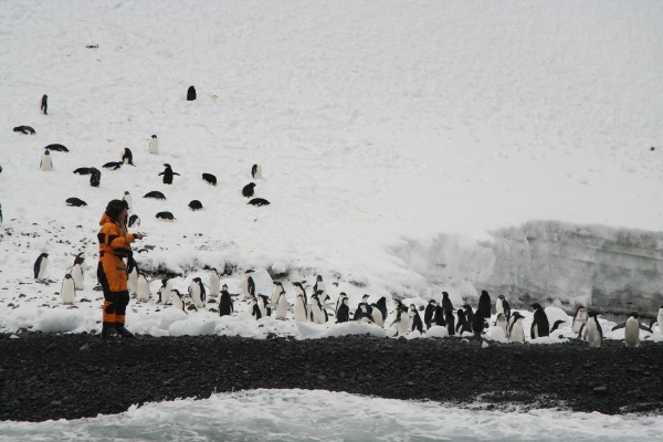
One of the expedition’s main aims was to collect a range of biological samples in which stable isotopes of carbon and nitrogen could be analysed back in New Zealand. Patterns of isotopes in different organisms reveal who is eating who. Remember that one of the purposes of this expedition was to assemble evidence that the Balleny Islands are important to the well-being of lots of creatures—and that includes that they dine there. Ashore, regurgitated stomach contents and feathers were obtained from moulting penguins, and fur was recovered from Weddell seals, the only pinniped seen during the visit. While the seals don’t breed on the islands, they do visit them and haulout there, although only a few dozen. Elephant, leopard and crabeater seals have previously been seen around the islands.
Rebecca McLeod recalls, “Clinton and I spent a day ashore surveying the penguin colony at Cape McNab, on Buckle Island. Climbing around on Cape McNab where no one had ever before set foot, was a truly surreal experience. Quite frequently, we would just stop and gaze in awe at our view—panning around from massive ice cliffs, to icebergs and Tiama which looked so tiny, out to a pod of humpbacks, not to mention there were penguins all around us. I felt like I was living inside a David Attenborough documentary. One morning we awoke to a fresh snow fall. Nick and I watched from Tiama as the Adelies ran up a 50 m high slope in groups, then skied down in rows, standing upright, on their feet! When they got to the bottom they would run back up and do it again.”
At Cape McNab, team members discovered an undocumented colony of chinstrap penguins containing 26 adults and 18 chicks amongst hundreds of the commoner Adelie penguins. Although chinstraps are abundant on the other side of Antarctica, previously a handful of birds on nearby Sabrina Islet was the only colony known for thousands of kilometres in any direction. Because of this colony, Sabrina has been designated as an Antarctic Specially Protected Area since 1966. On this expedition, the team counted 212 adults and 119 chicks at the Sabrina colony. “We really didn’t know what to expect when we went ashore, and were very surprised to discover many more chinstraps than in previous surveys. It looks as though the population is expanding rapidly,” Rebecca commented. Some 5000 Adelie penguins were also present on Sabrina. “Because they were moving all the time and some were as high as 200 m up the cliffs, we took photos and counted them off the photos.”Surprisingly, the penguins in the two colonies were at different stages of breeding and moulting, despite their proximity. The Sabrina chicks were much older than those on Cape McNab.
Several Adelie penguin colonies described by previous visitors could no longer be located. Indeed, Tiama spotted only one other tiny colony of perhaps 15 birds. In some places where birds had once nested, ice had advanced displacing them. Another change noted by the party was the disappearance of some of the rock stacks that Lewis had described at the south end of Sturge Island. That area was as far south as they went—celebrated by the consumption of a “furthest south cake” carried from home—and was very icy. “Sturge, which we circumnavigated, really felt like Antarctica,” commented Rebecca McLeod. “Ice covered almost all the land that we could see and broken ice was thick over the sea. Henk worried about his newly-painted hull getting scratched!”

Force sometimes checks the Ballenys. Sturge Island is seen from the south-west
and Buckle Island from off the east coast.
Even when the vessel was at anchor—anywhere around the islands—a watch was posted on the bow to fend off oncoming icebergs. Henk Haazen wrote in his log about the difficulties of anchorages:
Most of the better places to park for the night were close to the partly ice-free capes of the bigger islands or on the sides of the smaller islands that had more gently sloping hills and lower cliffs. Here we could get close in and find bottom without the threat of a house-sized lump of ice landing on the deck. Unfortunately none of the anchorages that we found allowed for the luxury of the whole crew sitting down below over a glass of wine. We always had to have one person on worry duty topsides. David Lewis felt strangely attracted by the frigid desolation of Sturge Island:
Vast rock buttresses, glaciers, ice shelves, bergs and pack ice passed before us in grand array as we motored down the coast of Sturge Island. What was the attraction of this bleak land, I asked myself? Over and above scientific curiosity it draws back again and again those who once have known its spell. Why? I suspect something adventurous in the human spirit responds to the very starkness of its challenge…” (p. 60 and 61)
A colony of southern fulmars was spotted high on Young Island, and this species of seabird was commonly seen at sea. Cape pigeons were breeding on Sabrina, but no other breeding birds were seen apart from skuas around the penguin colonies. At sea, the beautiful snow petrel was regularly encountered and several species of albatross put in occasional appearances. Massive flocks of petrels or shearwaters were also seen from time to time around the islands—an impossibility to number in the bird counts those aboard Tiama were trying to compile.
Underwater, the Balleny Islands proved more extraordinary than they were above. Again, the expedition had a preoccupation with tracing food chains, and in Antarctica all food starts from the ocean. What they saw from their diving and sampling was surprising and unexpected. Rebecca McLeod described it: “Large algae were really abundant, although they were a bit battered by the ice. And there was a lot of phytoplankton around, so vast primary production. And there were lots of sponges, tunicates and bryozoans and the like—encrusting filter feeders. But—and here is where it becomes strange—we could find almost no mobile larger invertebrates. There were no limpets or chitons or top shells or crabs or sea urchins. Just a few colourful cushion stars. On our way south, we had set light traps at night in the Auckland Islands and caught lots of isopods, amphipods, other crustaceans, worms, larvae etc. At the Ballenys, we caught nothing in those traps. It was surprising. Although krill are thought to breed in the area, and large aggregations have been documented here previously, our plankton nets failed to capture any. Nonetheless, krill were present in the regurgitated food being fed to penguin chicks and whales were feeding vigorously all around the islands. This is the only area in Antarctica where young Antarctic toothfish have been found but we were unable to locate any. They were possibly in deeper water than we explored. In fact, there were hardly any fish to be seen at all. We spent 30 hours fishing off Tiama and got four fish!

Several methods were used to glean data underwater. At the north-western end of Borradaile Island the team carried out underwater video transect work to inventory the Balleny Island’s shallow benthic communities. Throughout the archipelago, they lowered cameras to take photographs at depths ranging from 10–80 metres. In about 65 m of water, one camera drop revealed the seafloor crawling with pycnogonids (sea spiders) but few other motile invertebrates were seen. The team also averaged two dives each day and surveyed three rocky ledges using photographic quadrat methodology.
Nick Shears noted: “From this trip alone, we’ve found the diversity of algae species at the Balleny Islands is equal to or even greater than that of the entire Ross Sea. One or more of these species may be new to science.”
Franz Smith described one ledge where he could stick his hand into the sponges, hydrozoans and tunicates that seemed to be everywhere and his hand never met the underlying rock. The area was a mass of encrusting invertebrate species living on top of each other with worms and other life forms intertwined, so in some respects there was great richness underwater. But the absences were a puzzle.
[Chapter Break]
After 10 days in the Balleny Islands, Tiama set sail for Bluff and arrived there on March 5. They came home to a hearty welcome and a lot of analyses to do. Through this work they hope to establish the first baseline information for parts of the Balleny Islands.
Smith reflects that the trip also demonstrated that voyages like this are not only feasible, but may have an important role to play in future Antarctic research. The maneuverability of a small yacht like Tiama allowed the research team to access areas that a larger vessel would not have been able to reach.
Sharp comments, “The Balleny Island system may be more intact than any other ocean system in the world. Studies there can show how an undisturbed ecosystem operates and may point to how human activities have upset the order of nature elsewhere.”
The research that was carried out over the course of the expedition will help New Zealand build a stronger case for a Marine Protected Area around the islands, but the proposal still requires approval under the CCAMLR and the Antarctic Treaty System before it can proceed.
Reading the prosaic expedition logs of weather and daily work by Smith and Haazen obscures the remarkable journey the team made. Perhaps Haazen’s final entry in his voyage log for the summer of 2006 hints that the old salts found something to relieve their ennui in the Ballenys: “The remainder of the southern summer season was spent sailing to the NZ Sub-antarctic Islands supporting various research programmes. But nothing quite as exciting as the Balleny Islands.”