Winter’s gift: a southerly
What drives hundreds of seals on to the rocks around Cook Strait, brings jubilation to skiers up and down the country and can threaten the Canterbury rugby team with a loss to West Coast Buller, albeit by default?
The answer, of course, is a winter southerly.
Tuesday, June 5, this year saw the onset of a southerly that lasted for more than a week. Snow closed the Desert Road from Wednesday to Saturday, and no sooner had it re-opened than a slip just south of Taihape blocked State Highway 1 under three metres of mud.
Skifield operators from Mount Hutt to Ruapehu were celebrating snowfalls of 30cm or more.
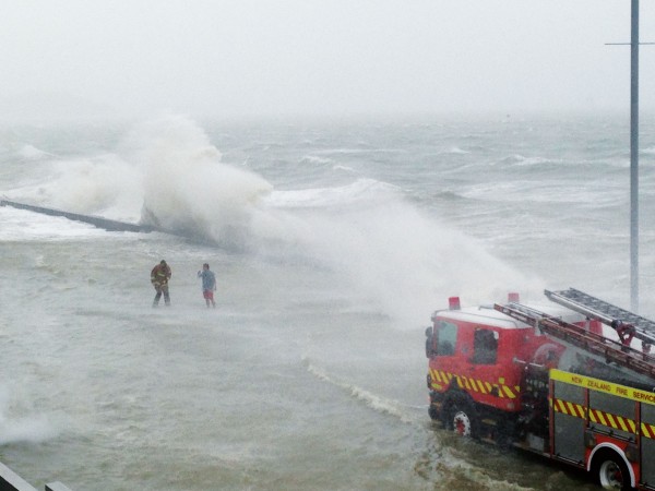
Southerly gales blew for days through Cook Strait, disturbing the seals and dumping tons of sand on to sections in Wellington’s Lyall Bay. Rain or showers fell every day for a week in eastern areas from Canterbury to Gisborne, while western and northern areas basked in sunshine. It was cold everywhere, and freezing fog in Otago left centimetres of ice on the fences.
Why did the southerly last so long? The answer lies in the pressure pattern shown in the weather maps.
During Tuesday and Wednesday a trough of low pressure deepened east of New Zealand and an anticyclone moved east across Tasmania. Between them a southwest airstream strengthened over New Zealand.
On Friday the southwesterlies tended southerly as the anticyclone moved southeast to lie south of Stewart Island by Saturday night.
With the anticyclone in this position the southerlies on its eastern flank acted like a river of wind, bringing cold air up to New Zealand from over the polar ocean.
Because the anticyclone was moving only slowly, this allowed sufficient time for the cold air to make the long journey up from the Antarctic. This trip takes the air two or three days, so if the anticyclone moves too fast the southerlies will have moved away before the cold air has got more than half-way to New Zealand.
Anticyclones that become slow moving or stationary for any length of time are called “blocking” anticyclones. One of the conditions that give rise to this phenomenon is a split in the strong wind flow at 10,000m known as the jet stream. What happens is that these high altitude winds blow around the anticyclone, much as water in a stream flows either side of a large stone.
There are certain places around the globe where jet stream splitting is common, and the Australia/New Zealand region is one of them. Why this should be so is not fully understood, but it is thought to be because of the particular distribution of land masses and ocean currents in our area.
One computer study suggested that the position of Antarctica may help determine where the jet stream splits. When the computer model had the Antarctic continent centred on the South Pole it predicted that there would be no split. When the South Pole was correctly positioned to one side of Antarctica the model correctly predicted the split in the jet stream over New Zealand and Australia.
Blocking anticyclones have an enormous impact on the weather. Although any one block may only last for about a week, there is a tendency for them to happen repeatedly some years, and hardly at all in others.
Persistent blocking over the United States five winters ago brought a prolonged spell of warm, fine weather to California, and a long run of cold weather with heavy snowfalls to the eastern seaboard.
If blocks occur repeatedly over New Zealand then we are likely to experience drought. If they occur repeatedly east of the Chatham Islands then New Zealand will experience prolonged northerlies bringing warm moist tropical air over the country with high rainfalls in many areas.
If, as we have seen in the June example, the blocking anticyclone is south of the Tasman Sea then New Zealand experiences prolonged cold southerlies with rain in the east, snow to low levels in the ranges and fine weather hi the west and north.
One of the great challenges for climatologists trying to predict the consequences of the greenhouse effect is to decide whether the changes to our weather patterns will involve more blocking anticyclones or fewer, and just where they will be located. The answer at this stage is unclear.
However, if we do get more situations like the June southerlies then one of the West Coast’s best kept secrets will get out. They have some of the best weather in the country during winter, and the Canterbury rugby team will have to fly over to enjoy it rather than risk having their bus stuck again in a snowy mountain pass.