


What lies beneath
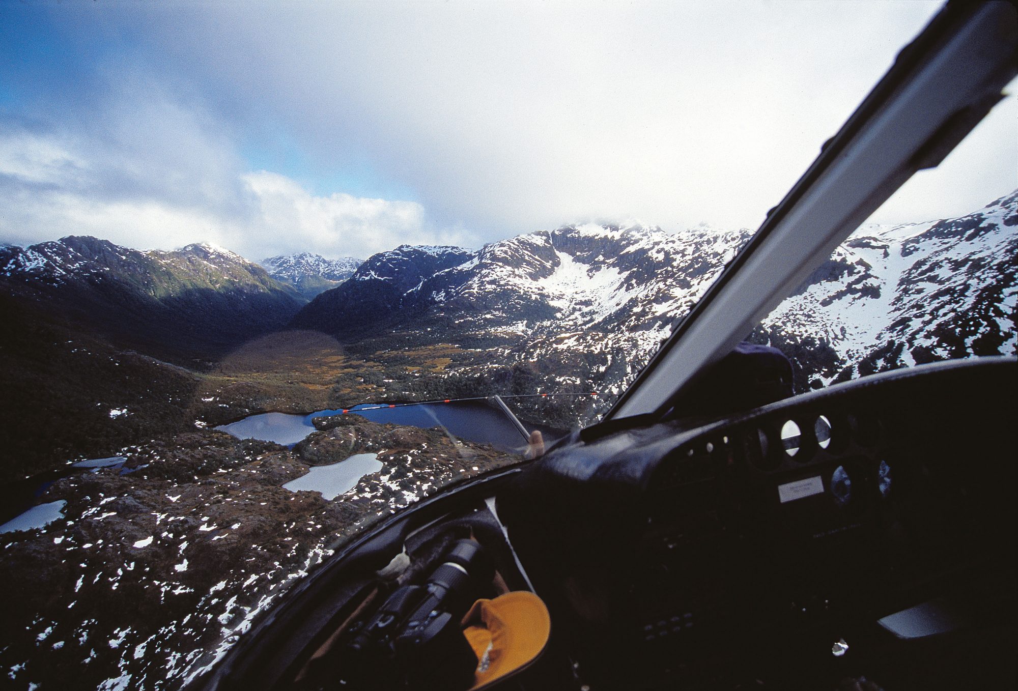
A helicopter flies over the Kakapo Lake area of the Cameron Mountains as it heads towards the drop-off point for geologist Ian Turnbull. He will spend a week recording and sampling the rocks inland from Fiordland’s West Cape as part of a project to produce new geological maps of the whole country
You could confidently say Ian Turnbull knows the lower South Island like the back of his hand. A geologist whose speciality is mapping, he has spent the last 30 years tramping across the dry barrenness of Central Otago, climbing the saw-toothed Remarkables and exploring the rainforests of Fiordland, seeking to understand what lies beneath his feet.
While most of us are content just to puff our way around the surface topography, the geologist tries to visualise the rocks which underlie the terrain—often there are several types in a single location, at different depths—and to deduce how they came to be in their particular configuration. The making of topographical maps has become almost effortless, for nowadays contours can be plotted from aerial photographs or radar imaging. With geological mapping, however, there is no escaping engagement with the ground, digging up and chipping off samples of rock as you go.
Turnbull and other geologists from the Institute of Geological and Nuclear Sciences (GNS) in Dunedin have been mapping Fiordland since 2001, and the task will take a few years yet. The Fiordland terrain is of legendary ruggedness, the bush is dense, rain is regular and tracks are few. Turnbull spends three months a year there.

At this moment, I’m standing next to Mo—Turnbull’s nickname—atop a bush-covered hill 350 m above Cunaris Sound, in south-west Fiordland. We’re on a small knob covered in moss and lichen, surrounded by stunted trees. Mo raises his geologist’s hammer and gives the rock a solid whack. After several more blows there is the satisfying thock of fracturing rock. Mo trims the shard and announces, “It’s diorite.”
As he takes a GPS reading, recording the exact location of the outcrop, he says, “Last summer we were mapping the edges of the sound by boat and found metamorphosed sandstone. I was pretty sure up here it would be different, as there’s diorite at the top of the ridge. It must have pushed up, or intruded, through cracks in the sandstone, then spread out along lines of weakness forming something a bit like a giant mushroom encased in sandstone. Since then, the sandstone has been eroded away.”
Diorite is a very coarse-grained igneous rock akin to granite. Its large crystals indicate it cooled very slowly, perhaps over hundreds or thousands of years, which only happens where molten rock is insulated from the surface by overlying layers of solid rock. Granite, diorite and other so-called intrusive rocks are abundant around Fiordland.
Mo is pleased to have solved this little piece of the puzzle, and his smile, as fleeting as the sun shining across the sound, is bright. This field trip is part of a GNS programme known as QMAP, the objective of which is to geologically re-map New Zealand. The programme was initiated in 1994, and so far 11 maps of the 21-map series have been published. Fiordland will be one of the last sheets to be produced, and GNS hopes to complete the QMAP job by 2009, replacing maps which were made in the 1960s.
Why do we need geological maps? Because, as Mo explains, they underpin many facets of modern life, though usually in unseen ways. Take something as ubiquitous as a plastic bag. Plastics are made from oil. Oil stocks are running out, and new deposits will be found only after long and expensive searches in sedimentary rocks—sandstones, mudstones and limestones. Oil companies require accurate geological maps to make such searches.

Consider steel or aluminium. You can be as green as you like, says Mo, but you’ll still ride an alloy bicycle with steel gears, eat with a stainless-steel fork or fly in an aluminium aircraft. Metals come from mines, and mining companies depend on geological maps in their search for the mineral deposits which support our lifestyle.
Then there’s electricity. Engineers rely on geological maps when siting and constructing hydro dams. “The landslides and fault lines that caused so much grief at Clyde were found during regional geological mapping, just like we’re doing here,” says Mo. Think of your house. Geological maps show the active faults that run under Wellington—and many other places, such as Fox Glacier—and so indicate the spots most vulnerable to earthquakes. They also show the distribution of landslides and of unstable rock formations, such as the Onerahi Chaos, which lies beneath Auckland’s northern fringe. Local councils and Transit New Zealand need to know about such areas when considering construction.
“What it boils down to,” concludes Mo, “is that everyone relies on geological maps, directly or indirectly. So that’s one reason why geologists do this—at least, that’s the reason which gets the most emphasis in these days of user pays.”
In Fiordland, Mo is mapping active faults associated with the Alpine Fault and the Dusky Fault. He has already mapped the sedimentary rocks along the south coast and in the Waiau Basin, which are potential sources of oil and gas, especially offshore. Now he’s mapping the different types of granitic and metamorphic rocks and tracing their contact points, trying to understand their evolution and relationships. Mining companies can draw on such data when searching for minerals in similar rocks overseas. As Fiordland is a national park, exploitation here is not an issue, although there are mineral deposits: gold in Preservation Inlet, ilmenite at Mt George.
Mo admits the fieldwork can be hard and uncomfortable, but says the intellectual effort involved is “challenging and fun—although mere scientific curiosity isn’t very saleable these days. The QMAP programme and the fieldwork are the main reasons I’m still working as a geologist. And the helicopters, of course . . .”
[Chapter-Break]
We flew in from Clifden to Lake Fraser four days ago. “We” are helicopter pilot Wayne Pratt, Mo, photographer Graham Charles and me. Graham and I are supposed to justify our presence by acting as Mo’s field assistants. Lake Fraser is as deep into the New Zealand wilderness as it’s possible to get. It’s 7 km from West Cape, the country’s westernmost point. Dusky Sound is 10 km to the north and Chalky Inlet 12 km to the south. The nearest settlement is Tuatapere, half an hour by helicopter, or, as companions of Mo’s found out in 2002, two weeks on foot.
When we landed on the shores of the lake I was initially disappointed—the landscape wasn’t especially dramatic. The rearing steepness of mountainsides and the roaring of waterfalls one associates with Fiordland were missing. Here were a lake and low, forested hills, nothing more. But, Mo explained, there is a reason why the hills are low. Tectonically, Fiordland is a southward-tilted block, so the mountains gradually taper in height the further south you go.


We set up camp above the “high tide” mark, a couple of metres higher than the lake’s current level. “Tides” here aren’t driven by the moon, they result from Fiordland’s legendary downpours, and Mo is careful to find a safe, dry site. In the summer of 2002/2003 he had to shift camp in the dark as floodwaters rose around him. Before setting off around the lake in an inflatable dinghy, we have a brew and I ask Mo what makes a good mapping geologist. He answers in typically succinct fashion. “A good imagination and the ability to think in 4D.”
The fourth dimension is time. Landscapes change dramatically over time, and rocks preserve a record of that change. Sedimentary rocks, for example, are usually laid down under water. Whenever they are lifted above water, they start to erode, and geological evidence is eradicated. Just because a cliff forms a continuous face of rock doesn’t mean that it consists of an unbroken time sequence of rocks. There can be gaps—or anomalies—which mappers like Mo have to detect. In Fiordland’s case, glaciers covered the region only 10,000 years ago, and these ground a fair amount of rock to dust and rubble, most of which was washed away in meltwater. This was but the most recent of a long succession of abrasive ice ages. Reconstructing the history of the land is far from easy.
Of course, Mo isn’t the first geologist to chip at Fiordland’s ramparts. Previous mappers, however, have focused on particular areas—Milford Sound, Mt Pembroke, Doubtful Sound. Until now, nobody has looked carefully at the geology of the region as a whole. Furthermore, some of the earlier work has proved wanting. A geological map published in 1960 shows the area around Lake Fraser as being composed entirely of granite, yet, as we discover, the real picture is far more complex. The mappers didn’t have sufficient time to see much of Fiordland. As Mo says, “They didn’t rub their noses on it.”
[Chapter-Break]
The follwing afternoon we head north over a low saddle and drop into an unnamed stream. Mo wants to try and link up with a section of rock he and a colleague mapped last year when they were camped on the tops. Mo has nicknamed this rock Dead Marshes Granite (DMG).
Late in the day we find outcrops of what seem to be DMG. This is a significant discovery, as it indicates that a coherent block of granite runs from near Dusky Sound to West Cape. We continue up the stream, using it as a pathway, and the going is relatively easy, though sometimes we wade up to our waists.
About an hour later we locate a band of streaky grey gneiss, a metamorphic rock. Downstream we saw only speckled granite. Mo speculates that there is a fault running down the creek, because many of the rocks are shattered. We make a detour up a side stream, and, indeed, come across a fault exposed by a large slip. The next day, the wind hurtles across the lake and mares’ tails swoop overhead in an angry sky. We load up the boat and motor across to the southern shore. Mo wants to explore up a side creek, along the tops and down to the outlet of the Newton River, near West Cape.
Half an hour up the creek we find an outcrop overlain with moraine. Mo points out a spot where rocks once encased in the bottom of an advancing glacier have sheared off the underlying outcrop, creating what appears to be a fault within the moraine. But he’s also interested in the underlying gneiss with deformed quartz veins. We carry on up the creek, and it feels as if the bush is attempting to smother us.

Leaving the gulch, we scramble up a ridge. Mo says this is a lateral moraine from the glacier which carved out Lake Fraser. Travel is easy along deer trails, although the wind has stunted the vegetation. On the crest of the ridge we’re hit by a wall of wind. Mature trees, snapped by past storms, are strewn around. In the strongest gusts, movement of the shallow-rooted trees—gnarled, battle-weary specimens—causes the ground to heave.
Further along we finally get a glimpse of West Cape. Even from this distance we can see slow-motion spumes of white erupting against the coast. We drop off the ridge and struggle through thick bush to a low hill, where Mo hopes to find a connection with the DMG.
In the bush there are no streams or clearings, and I’m wondering where Mo thinks he might find his outcrop. We skirt around another hill, separate from the first, and come across a windfall. Up through a tangle of vegetation there is an area of exposed granite some five metres across, a lone patch of white among the green. Is this good luck or skill? Mo explains that he studied the topographical map and could see this hill was separated from the moraine, indicating it was likely to be solid rock.
Mo thinks the rock is DMG. A tentative identification can be made in the field by testing a sample for hardness with a pocketknife and examining it with a magnifying glass to identify constituent minerals. However, a positive identification can only be made in a laboratory, where a section is cut from a sample and ground to a thickness of less than a tenth of a millimetre, by which stage it is transparent. This is then put under a microscope equipped with a set of polarising filters. Crystals alter polarised light in characteristic ways, enabling identification.
[Chapter-Break]
Mo’s office in Dunedin, though far from the wilds of Lake Fraser, still carries echoes of the field. On a shelf are numerous empty whisky bottles, mementos of many arduous field trips. I’ve followed Mo here to see how the data gathered in Fiordland are used in the production of a map. If you enjoyed colouring-in as a child, you would probably enjoy the process of making a geological map, because assigning colour is a significant part of the process. Each colour on a map represents an area of identical rocks of the same age. Similar colours are used for comparable rocks across the country to maintain uniformity.
Before the colouring-in phase, though, Mo transfers all the information from his field books onto a transparent sheet overlying a 1:50,000 topographical map. Every tiny geological detail is included—every moraine, fault line, stretch of beach gravel, swamp deposit and type of rock. The sheer quantity of information is staggering. For example, on the Wakatipu sheet there are 3809 faults—not all active, fortunately.
Once Mo and his colleagues have plotted all the field observations, made inferences about possible faults or relationships between rock types, looked at thin sections of rock under the microscope, and maybe carried out radiometric dating on some samples to ascertain how old they are, the map is filled in using coloured pencils. It is then simplified, digitised and shrunk to a scale of 1:250,000.

The finished map uses combinations of lines, colours and symbols to show the composition, structure and history of the rocks that underlie the landscape. The QMAP sheets show the spatial distribution of bedrock types, such as granite in Fiordland, greywacke in the Southern Alps and volcanic rocks in the Coromandel, of younger sedimentary rocks, such as limestone, sandstone, coal and mudstone in Southland and Taranaki and on the East Coast, and of surface deposits, such as gravel terraces in Canterbury and dune fields in Northland. They show geological structures such as the Alpine Fault, the Wairarapa Fault and the Southland Syncline. They also provide an interpretation of how these substances and features are related in space and time; in other words, they depict how the land was made. In the QMAP series, much of this interpretation is conveyed in an illustrated book that accompanies each map.
Mo comments that making maps is at once the most generalised and the most specialised of “the dark geological arts.” “You have to be competent in all branches of geology, not just granites or volcanoes or faults,” he says, “and you have to be prepared to call in experts when you’re out of your depth.
“It’s said that the best geologist is the one who’s seen the most rocks—so experience counts. But the thing that really makes a good geological mapper is that instinct for thinking in four dimensions. All the time we’re out in the field, we’re looking at more than just the rock in the outcrop. We’re looking for evidence of faulting and folding, for the minerals that tell us if the rock has been metamorphosed, at the gravels to see if they were deposited by glaciers, rivers or the sea. We’re examining the sedimentary rocks for evidence of oil and for fossils. Using these observations, we instinctively picture the landscape as it was in the past—covered in ice, under the sea, or in unimaginable heat and pressure 20 kilometres down, where the rocks flow and the granites grow.
“We are, of course, helped by knowing what other geologists have found, both here and elsewhere in the world. Geology is a global science—in fact, it’s interplanetary and someone who writes a book on granite in the Sierra Nevada, or on the folding of greywacke in the Himalayas, is helping us understand New Zealand geology. And wherever we go, we make sure we are familiar with work that’s been done before in our patch. I’ve gone back to Alexander Mackay’s geological work of 100 years ago and to Charlie Douglas’s observations in the Waiatoto. There are always many pages of references to earlier work—material that has to be assimilated as a map takes shape. That said, in Fiordland—as in large parts of the Southern Alps or the Ureweras there are many places where no geologist has ever been.”
Even at the draughting stage, geological knowledge and skill are required. Every area of rock on a map has to be characterised in terms of age, mineral composition, relationships with adjacent rocks and similarities to rocks elsewhere in the country. The age of every fault is recorded (or ages, if a fault has moved more than once) and the direction and distance of movement noted.

Cross sections are then drawn to show what lies below the surface, and the text of the bulletin accompanying the map is written. Here the entire spectrum of rocks in the mapped area is described and interpreted, and all the derivative engineering, economic and hazard connotations of the geology are explained and illustrated.
The advent of computerised Geographic Information System technology has revolutionised the storage and presentation of geological map data. “Once it’s all in the computer, you can do anything with it,” says Mo. But this hasn’t obviated the need for fieldwork, for getting wet feet and “rubbing your nose on the outcrop”—for visiting Lake Fraser and dozens of places like it.
Discoveries by dogged researchers like Mo Turnbull and his colleagues in remote places are unlikely to make newspaper headlines. But there is a profound satisfaction in unravelling nature’s secrets. Old Charlie Douglas understood this when he wrote in his “Soliloquy Letter” a century ago, “the impulse which impells [sic] some people to search for knowledge in the unknown is for the benefit of the world, and cheaply bought at any price.”


