


The mountain has spoken
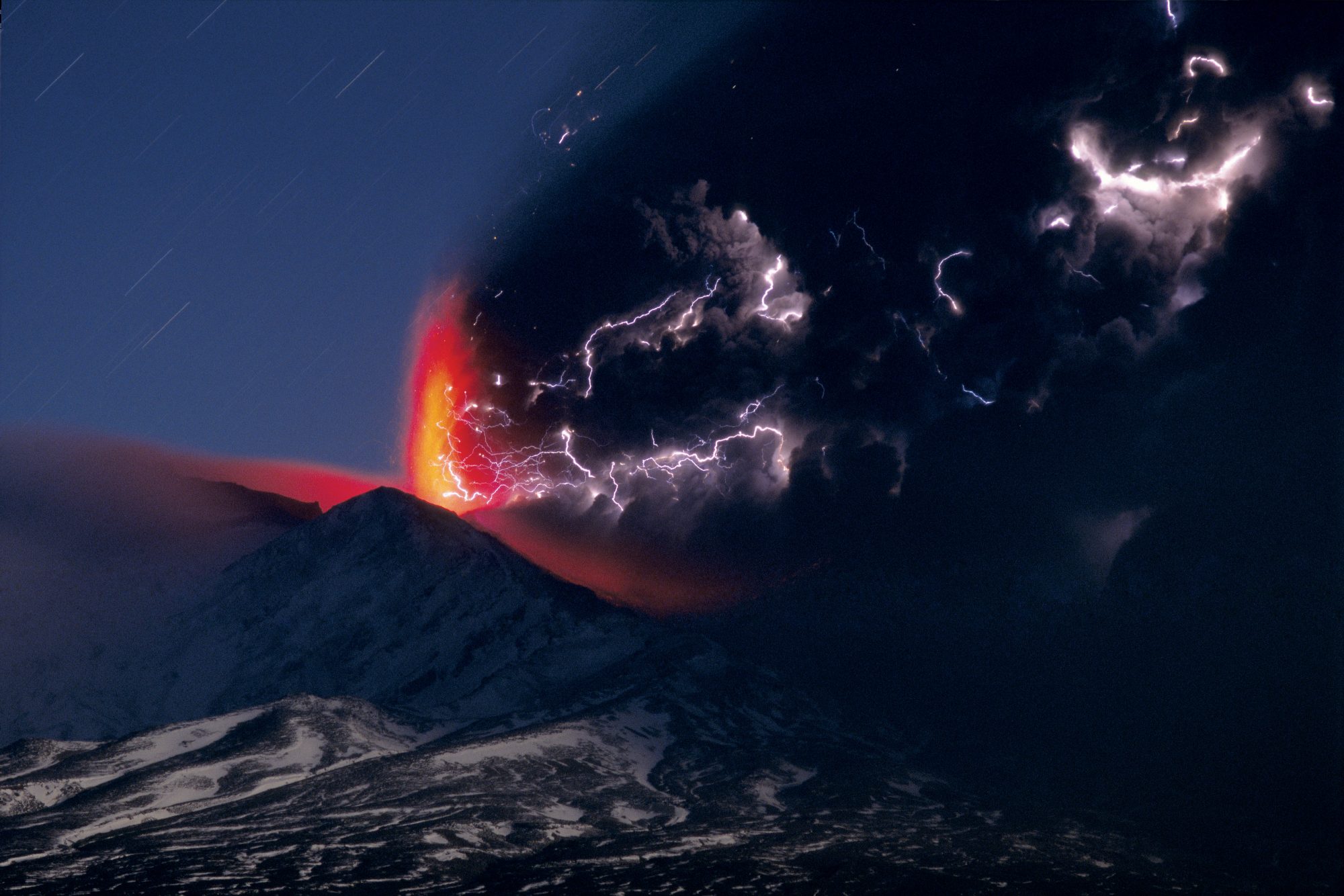
As if to celebrate the 50th anniversary of its last major outburst, on September 18, 1995, Ruapehu sprang unexpectedly from repose to violent activity. Over the next few weeks a white plume billowed to over ten kilometres above the mountain, raining black showers of ash across most of the North Island and disrupting air and ground traffic. On the night of October 11, with most of the water from the crater lake exhausted , molten magma fountained from the crater for several hours. Shafts of lightening cracked through the base of the dense ash cloud every few seconds. Fire had come to the mountain again.
“Just one more shot,” Helen begs. For over a year, she has been photographing the North Island’s volcanic central plateau: its sudden peaks in a flat tussock desert, its boiling pools a stone’s throw from ice-cold lakes. Now her year is up, and I, as part-time tripod carrier, am ready to go home.
It is a cold evening in mid-September. Not a good time to be sitting in Dome Shelter, on Mt Ruapehu’s summit plateau. But, as I have learned well by now, photographers are not easily dissuaded.
I shield Helen from the fierce southerly wind as she works. Glad of the comfort of my Gore-tex and polypropylene, I glance at the usually grey-green crater lake. It is black and still. Not a puff of steam anywhere. I think of the bad weather threatening, the sinking sun, the ghosts of six dead soldiers, killed in 1990 in a storm a few metres from where I’m standing. The mountain, I am convinced, wants to be alone.
Forty-eight hours after those photographs were taken, on September 18, Ruapehu erupted, sending a lahar (mud flow) skating down the Whangaehu River. More eruptions followed. On the 23rd and 25th, lahars blossomed on all sides of the mountain, filling the Whangaehu, the Whakapapaiti and the Mangaturuturu Rivers with silt and debris. Locals watched wide-eyed as black mud snaked down snow-white slopes, and national newspapers filled with stories of roads closing, planes grounded and army families evacuating from Waiouru.
On September 25, a toilet block next to the Tangiwai bridge filled with mud. In 1953, a lahar destroyed the railway bridge at Tangiwai, killing 151 people when the Wellington to Auckland express plunged into the Whangaehu River.
The 1995 blasts continued on October 7, with a column of ash and gas reaching 7.5 km into the sky, and lava blocks thrown a kilometre from the crater. Ash again carpeted the Desert Road on October 14, and as we approach Christmas the mountain still bellows periodically with ash and clouds of sulphur dioxide gas.
Will things ever feel safe again? Auckland, my home, is a city built on a field of 48 dormant volcanoes. Who knows what boiling secrets lie beneath them?
Six million years ago, Northland was a land of snowy peaks and busy volcanoes, long since flattened and extinct. But is there such a thing as an extinct volcano? Once that underground vent is there, what’s to stop a desperate flow of magma from resorting to its old ways?
The geological record tells an alarming tale. The Taupo Volcanic Zone, stretching from White Island to Ruapehu, is one of the most active areas of its type in the world, and its cone volcanoes—Ruapehu, Ngauruhoe and White Island—are among the world’s most frequent performers. In 186 A.D. Taupo produced the biggest eruption the world had seen in 5000 years. Big enough to create a flow of pumice and hot ash which submerged an area from Rotorua to Waiouru and across to Taumarunui. High enough to turn the sky red in Rome and China. And fast enough, at up to 300 kilometres per hour, to race up and over Mt Tongariro.
Taupo’s biggest outburst was 22,500 years ago, and there have been 28 eruptions since. The lake will certainly erupt again. As for Taranaki, he’s just resting between outbursts. The last was in 1750 A.D.
Here is the most frightening statistic of all: The biggest single source of fatalities from natural disasters in New Zealand during the last 150 years, has been, either directly or indirectly, volcanic activity.
Following hard on the heels of Ruapehu’s first eruption, “Volcanic Hazard Awareness Week” rolled into town, with displays and a two-metre-high fibreglass volcano which puffed obligingly when you pressed the red button. The timing was a fluke. The national educational programme had been organised 18 months beforehand by the Institute of Geological and Nuclear Sciences to mark the 50th anniversary of Mt Ruapehu’s last big blast in 1945.
It’s the sort of publicity you can’t buy. A sign on the exhibit, set up in an Auckland shopping mall, warned “It’s not a case of IF the next big eruption will occur, but WHEN.”
When indeed. Driving towards Ruapehu, I see volcanic mounds everywhere. The flat land only accentuates a struggling cone. A puff of smoke in the distance catches my eye, but it’s just a farmer spreading fertilizer. I turn the radio on. A voice announces, “Things are hotting up!” But he means the weather.
Midnight in Ohakune, the nearest town to Ruapehu, and I and a soccer team from Napier are shocked out of sleep by a wailing siren. Having convinced ourselves that yes, there is a strange yellow glow over the mountain, we plan our evacuation. The prospect of becoming a lava-encrusted Pompeii-style tourist attraction in the company of 11 soccer players holds little attraction.
The siren turns out to be only a fire drill. Embarrassed, we slink back to our rooms.
[Chapter Break]
Next Morning, Ruapehu is a fine piece of furniture hidden under a lacy white sheet. The sheet is a thick mist of sulphur dioxide gas, the breath of the volcano. At this distance, the gas is smelly but harmless, though your eyes sting. At higher concentrations it can be lethal, and when mixed with atmospheric water it falls as acid rain.
I find the Ohakune locals calm, down-to-earth and getting on with their lives. The people who panicked, I am told, were from out of town. A theory suggests itself: Those who can’t see an erupting volcano are more likely to panic than those who can. The closer you are to the mountain, the calmer it gets.
Ruapehu stands in a great plain, the eastern part of which is referred to as the Rangipo desert. It is not exactly desolate, but it is raw, moody and smells of a violent history. Frequent dry winds blast from the northwest and scare the rain away, hence the sandy soil and the desert-like conditions. The army, based at Waiouru, has shelled the place almost daily since 1932, and an earlier history tells of a battle fought for the desert and its godlike mountains.
As the Tuwharetoa people tell it, their ancestor Ngatoroirangi arrived in Aotearoa on the great canoe Te Arawa. Heading inland, he met Ngati Toa leader Hapekituarangi in the desert, and they fought for the land. Climbing Tongariro, Ngatoroirangi called on his gods for help, and they sent dense black clouds and snow, destroying his rival. Since then the desert has been known as Rangipo (darkened skies), and its sands treated as sacred.
Not much is sacred about the electricity pylons marching rudely across the tussock. Ironically, they were one of the first casualties of the eruption. A heavy fall of ash shorted the electricity supply and began to corrode the metal, causing problems throughout the North Island. A warning to the big corporations that in this area someone else has the monopoly.
On the southern side of the mountain, at the Turoa skifield, the remains of the lahar from September 23 look like dried treacle on a Christmas pudding. On the northern side, at the top of the access road, the Whakapapa skifield . well, how can you prepare yourself for the sight of charcoal snow? The entire contents of the crater lake—hot water, rock debris, mud and ash—have been sprayed over the mountain, leaving a gaping hole at the top and a blasted land below.
The slopes of Ruapehu have been abandoned. People are not welcome; that’s the feeling you get. Not by the mountain, anyway. The ski lifts, now the same colour as the snow, look like a child’s discarded Scalextric kit. And the ski lodges, with their confident names—Boomerang, Snow Line, Schuss Haus—are Monopoly hotels scattered on a fragile board.
Like a snake shedding its skin, this volcano has re-invented itself, as it has been doing for half a million years. Ruaumoko, the unborn god of earthquakes, and Hinewera, the goddess of fire, celebrate the birth of the new through destruction; just as Vulcan, the Roman god of fire, works his transformations in the giant blacksmith’s forge beneath Mt Etna.
Ruapehu, at 2797 metres the highest point in the North Island, has reshaped itself four times in the last 50 years. Particularly violent eruptions in 1969 and 1975 produced lahars which caused considerable damage to the Whakapapa skifield, to bridges and to parts of the Tongariro Power Scheme.
Standing close by, the classic Mt Fuji-style cone of Ngauruhoe, and at 2500 years old the youngest vent of the sprawling Tongariro range, has, until recently, been spitting car-size chunks of lava every few years. The other more sedate craters of the Tongariro range puff away and watch the younger members of the family behave badly.
People have been navigating their way through this extraordinary landscape for hundreds of years, trying to understand and answer the talkative mountains. For some it is a place to pray. For others a place to test weapons. For successive governments it has been a convenient lock-up. There have been prisons in and around the Tongariro National Park since the first world war, when conscientious objectors were sent to do time with the volcanoes. For farmers, the volcanic soil is ideal for growing carrots. For volcanologists, it is a place to study, measure, watch and analyse.
Working on the theory that the more you see the mountain, the calmer you become, I went to visit the volcanologists at IGNS. Expecting to find models of repose, I was introduced to a battle-fatigued Brad Scott, who emerged from behind a closed door to apologise. He and his colleagues were in the middle of a debriefing session, and no-one could see me until the afternoon. He confided that the pressure of coping with the continuous hot steam from the media was taking more of a toll than the fiery mountain ever had. Woken morning after morning by headline-hungry journalists, having to calm an angry overseas film crew who have turned up expecting to film the North Island exploding; all this was becoming an unpleasant baptism by fire for these usually sanguine scientists. “It’s like being in a tank of piranhas,” said group leader Colin Wilson, when I talked to him later.
“It’s nice to see a volcano erupting,” he said, “but the seduction for us is the science, not the volcano. Studying a dung beetle is as exciting as studying a volcano. It’s taking something and being able to understand why it operates, how it operates, what makes it tick. I take prehistoric eruptions and try and work out what went on. That area of pumice over there—we think we know what time of year that eruption occurred, even what time of day. It’s rather like forensic science. With this eruption we can map out the deposits as they occur, and link the prehistoric with the historic.”
Peter Otway is the volcanologist on the team who spends most time on the mountain. His office was everything I’d expected of a field scientist: tramping gear piled up in the corner, photos of past eruptions on the wall, a scattering of maps and diagrams charting the crater lake temperature and its expansions and contractions as it groans in and out of its giant labour.
“We did a survey just before the big eruption on the 23rd, and that showed a 23 mm expansion across the crater lake. That’s not much, but it’s significant,” he told me.
For the last 30 years, Peter has had his ear to the ground measuring, watching and listening. Like a flea on the back of a beast, he has sometimes been flicked off.
Moments before the 1971 eruption on Ruapehu, Peter and his team, having finished their Crater Lake measurements, were waiting on Pyramid Peak for a helicopter to pick them up.
“While we were sitting there, a medium-sized eruption leapt up. I picked up my camera and took a photo, just as the sky was filling with great black fingers. They came straight for us, and then shot over like a hot black waterfall. You could hardly breathe because the air was full of ash, and we could hear big rocks whistling down all around us. I didn’t expect to survive. I thought, `You’ve got me now. You’ve been trying all these years, and now you’ve done it.’ When it stopped, I looked out from under my pack and there was a big rock a metre from my feet, steaming away, melting a hole in the snow. It was a miracle that we all survived.
“Some of us had nightmares afterwards. The surprising thing was that I wasn’t aware of any sound during the eruption. But later it came back to me. The whole place was just reverberating. We worked out that it must have been moving at one-anda-half times the speed of sound, so it was creating a sonic boom.”
After years of study, Colin Wilson told me, you get to know your volcanoes like a family. It seemed to me that what Colin and his team were offering was unconditional love, no matter how dysfunctional their family’s behavior.
“Each of the volcanoes has its own character,” Colin elaborated. “It’s like you’re walking down the street and you recognise someone on the opposite side of the road. You know there’s an infinitesimally small chance they’re going to pull out an Uzi machine gun and blow you away. You know there’s an equally small chance that they’re just going to drop dead of a heart attack. It’s so improbable that you don’t consider it. The most likely thing is that they’ll wave to you, come across and have a chat. With Ruapehu, we know what the most probable course of events is likely to be. But there’s always the possibility that it could act out of character.
“Ruapehu is something of a tweed-jacketed gentleman. He works within conservative boundaries in terms of size and style of eruption. Taupo is much more irregular. He’s more of a teenager who’s not sure whether he’s going to bash that old lady or help her across the road! Ngauruhoe is a good-looking, well behaved volcano, very quiet. Since 1975, the thermal activity on Ngauruhoe has reduced greatly. He’s in deep slumber. Tongariro is definitely hibernating, but could come back to life one day, and you can imagine the panic that would cause.”
[Chapter Break]
Volcanology Has Only really developed in the last 45 years. The Ngati Rangi people from the Ohakune area, on the other hand, have been watching and interpreting the chattering s of Ruapehu for many hundreds of years. To the Ngati Rangi he’s not exactly an English gentleman. He’s the rangatira, the big chief, and he’s a sacred place. He’s a tupuna and a mama, an ancestor and a parent. But he’s still a place to hunt: mutton bird, kereru and, many years ago, moa. He’s also a place to pray, and the crater lake was once a smoking place to lay special bones to rest. Ngati Rangi’s name for the crater lake is “Nga wai a moe,” sleeping waters—in a mountain very much alive.
Matiu Mareikura, kaumatua from Maungarongo Marae in Ohakune, has no intention of moving away if the mountain continues to erupt.
“We don’t have that option,” he explained. “We’ve been the mountain’s kaitiaki (custodians) from the beginning of time, and it’s not our duty to leave. Keep out of its way while it’s doing what it’s doing, yes. But leave the mountain, no.
“Ngati Rangi’s history,” he continued, “is a lot older than anyone else’s, because we were here before any of the canoes arrived. Pairangi i te where toka’—that’s our ancestor, Pairangi from the house of stone.’ So our concept of the mountain goes right back to the beginning of time, when Maui went fishing.”
Maui, as the legend tells it, went fishing with his brothers and fished up the North Island—Te Ika a Maui (the fish of Maui). But he couldn’t tame the fish. So he returned to Hawaiki to bring back the proper incantations to enable him to complete the job. In his absence, his brothers tried to kill the fish, and out of the bruising and swelling grew the mountain of Ruapehu.
“Ruapehu was left there on his own,” Matiu takes up the story, “so he asked Ranginui [the sky God], `What gifts can you give me?’ Firstly he was given two tear drops. One was the Wanganui River, the other was the Tongariro. He then petitioned for companionship, and he was given ‘mama te tapu,’ Taranaki, the sacred mountain. When he asked again, he was given the warrior mountain, ‘mama te toa,’ Tongariro. Next, Ranginui gave a mokai, a slave, to do the mountain’s bidding. That slave is Ngauruhoe. Finally, he gave one more gift: Pihanga, the beautiful wahine to appease the warrior Tongariro.
“As time went on, Pihanga started to look away from Tongariro towards the slender Taranaki, and when Tongariro saw this, he literally blew his top. He ruined his good looks with rage and fury! Ruapehu commanded Taranaki to go to the west to be the custodian of the setting sun.”
Today, Ngati Rangi have a claim on the mountain. It is a plea, says Matiu, to create a balance between playground and church.
“For us, the mountain is a wahi tapu, a sacred place. But that doesn’t mean you can’t go there. Right at the pinnacle there are areas set aside for special reasons. Those are the places where you and I should not stand. But at the moment you can go anywhere. We don’t want to see the skifields closed. It’s about setting boundaries. And right now there are none.”
Post-eruption, the skifields were closed and the ski bunnies, grumpy behind dark sunglasses, packed up their cars and headed back to the city. One day they may come to appreciate that their playground is also a church. Have fun, but don’t eat lunch in the confession box, and don’t sit on the altar.
John Luff, field centre manager for the Department of Conservation, is hopeful. “The concept of DOC is really a balancing game: use versus preservation. Then you have different types of users who are in conflict all the time, and we have to balance their different values. If the claim is resolved in favour of Ngati Rangi, then I can see a day when the likes of myself become redundant. That may not be for another 10 or 20 years. But at the end of the day it doesn’t really matter who’s looking after the mountain, as long as it’s being looked after. And I don’t believe Ngati Rangi want to lock people out of the place. There’s no need for people to feel so threatened.”
Balancing the needs of Ohakune Maori, Pakeha, Chinese, shopkeeper, farmer, tramper and motel owner is a challenge. How do you cope when one group of people wants to swim in the warm crater lake, while another honours it as a burial ground?
Despite the misunderstandings, there is common ground. Most people in Ohakune are united in staying put, one eye on the mountain, the other on the ground. During the big blasts, it was not uncommon to see someone walk towards the mountain, binoculars and camera around his neck, a chair in one hand and a six-pack of beer in the other.
True, some locals did a runner. One family, having witnessed the first signs of eruption, filled the shops with “I survived ’95” T-shirts and promptly fled to Wanganui. But mostly it was the tourists, the out-of-town staff and the skiers who beat a hasty retreat. The BP garage at Ohakune was sucked dry, and Wendy at the library lost a few books.
Staying put is one thing. Looking is another. And when the Ohakune people watch this eruption cycle, each one sees something different.
“I suppose in terms of race relations, it’s one of the most explosive times in our history,” says Matiu Mareikura “The mountain has certainly chosen its moment.”
But for some the eruption has simply meant financial disaster. No skiers means no drinkers, no sleepers, no spenders.
For others it’s a chance to make money. T-shirts aside, there are photos for sale, eruption home videos, posters, even Marmite jars of ash and lahar mud for sale at the visitors centre. In the local kebab shop you can buy a “Volcanic Special.” Don’t ask me to explain, but it’s a kebab full of fruit.
The volcanologists assure people there is no connection between Moruroa and Ruapehu, but there are those who see it as a sign. If there isn’t a connection, there should be, they say.
Some believe that meddling with the mountain’s water works has created danger zones under ground. (The Tongariro Power Scheme’s complex system of lakes, dams and aqueducts drains 320 square kilometres of mountain catchment.)
Whatever their angle on the eruption, most Ohakune locals are awestruck. They have something of a love affair with their mountain. Maybe even an obsession. Murray Swann, who owns a lodge in town, had been videoing the mountain nine months prior to the eruption.
“I suspected something was going to happen when we started getting hydrothermals—those little steamy clouds from the crater lake. I started filming at night, getting up at crazy hours to change the tape in the camera. People laughed at me, even when I was on top of the roof filming the morning the big eruption started. They’d say, ‘Oh, there’s Murray with his security camera!”
Today, Murray has exclusive footage of the eruption from beginning to end, and his video is selling for $20. He and his wife Janet are prepared for any new tricks that Ruapehu cares to throw. Murray has built a platform at his window for the camera to sit on, on stand-by. And the cat has an ash mask, made out of an old stocking.
Allan Whale-Gammeter, an Ohakune farmer, can say he has a unique connection with the mountain. Two hours before the eruption on the 23rd, he flew over the crater lake and sprinkled his mother’s ashes.
“My mother had climbed Ruapehu 13 times. She always wanted to have her ashes scattered there. It Was her birthday, too. She would have been 80 years old. She was a real character. I knew the crater lake had been warming up, and I remarked to the pilot flying the plane, `She’s going to have words with somebody. Either everything’s going to go dead quiet, or it’s really going to blow.’ And within two hours, BOOM! Up she went!”
John Nation, Ohakune’s baker for 50 years (and justly famous for his chocolate eclairs) is almost indifferent to the eruption. He’s seen it before, and says that nothing today compares to the nuisance value of the 1945 eruption.
“You just take it in your stride. It hasn’t affected my life really. Not like in ’45. That was just terrible because a lot of people only got their water off the roof, and Ohakune was covered in ash. This time we haven’t had an ounce of ash on this side. But even in ’45 it didn’t concern me too much. The war toned down the awesomeness of the mountain. I was too busy dreaming of being a war hero. I suppose we don’t take it seriously enough. It could erupt continuously for six months and bury the town, but you would just carry on with your life anyway.”
Ash in 1945 may have sullied the water supply and irritated the throat (a particular kind of sore throat in Ohakune became known as “Ruapehu cough”), but hazard awareness was low. National Film Unit footage from the day shows skiers smiling in the foreground with the mountain erupting behind. People were even picnicking above crater lake, while the geologists of the day, Errol Flynn-like, smoked and jumped in and out of holes to the sound of Wagner’s music. Hardly the two-kilometre exclusion zone around the mountain today.
The power of this current round of explosions has matched and sometimes surpassed that of 1945. And it may not be over yet. The 10-month-long 1945 eruption was punctuated with deceptively quiet periods, sometimes lasting up to a month. Today, the mountain continues to tease with plumes of gas and a sprinkling of ash. Nobody can say what lies ahead.
[Chapter Break]
How do you prepare a society for a volcanic eruption? This is a question of more than passing interest to David Johnston, who is writing his PhD on the potential impact of a big eruption.
“Our society is more vulnerable now than it was in 1945. To begin with, there are more people—but that doesn’t mean that more people would be killed or injured directly. What volcanoes can do is severely disrupt infrastructure, and that has a flow-on effect: electricity cuts, the closing of airports, roads, water supply, sewage.”
Everyone agrees that it takes more than a fibreglass volcano in a shopping centre to awaken the masses. This year’s volcanic awareness week (which David Johnston organised) involved school talks, an art exhibition and, a few weeks before the blast, a joint IGNS, DOC and Civil Defence lahar evacuation exercise at Whakapapa.
“The timing was incredible,” marvels Des Price, Civil Defence Officer for the Ruapehu District Council. “Not only that, I’d spent two days at the Ohakune school talking about civil defence and evacuation procedures, and I found, even then, that the kids knew a darn sight more than I thought. Maybe it has to do with proximity to the mountain. One little fellow said to me—and this really made me think–`If we have to leave, what do I do with my pet turtles?’ I told him to wrap them in a wet towel!”
“The children are very used to the mountain with a bit of steam,” Ellen Gould, the Ohakune primary school’s headmistress, told me “And they didn’t panic too much when it went up. I had more problems with some of the teachers!
“When the television cameras came to film the kids, they kept asking them, ‘Did you panic? Were you scared?’ But the kids were quite calm. So the television people asked me would I ring the alarm, and they could film the kids then. I said ‘No, I definitely will not!”
Twelve-year-old Alesha, of Ngati Rangi, is confident the mountain won’t hurt her. She believes there is a reason for his angry bellowing. “He’s just warning the Pakeha they’ve got to treat him better. All they want to do is make money out of him, and that’s treating him like nothing. Look, he’s covered himself in cloud today because he doesn’t want to frighten us. He wants time to himself.”
Another girl is convinced the mountain is erupting “because my mother said it would.” A 10-year-old boy reckons the big chief is just bursting a pimple. The school walls are covered in erupting mountains: pink ones, black ones, splattered paint versions. There’s a picture of Ruapehu commanding Taranaki to head west, and another with the title “Our maunga [mountain] likes to smoke.”
And that’s just it. Ruapehu is doing what volcanoes do: smoking. Most of the time he’s content to be all things to all people, a gentle giant of a chameleon. But with one swish of his tail he can send the skiers, the trampers and the sightseers running for cover, ignite a spark of debate in a community and thrust the reluctant volcanologists into the spotlight, where they squirm a little.
Finding out what lies behind nature’s own fire and steam displays is more than just a job for these mountain scientists. As part of Volcanic Hazard Awareness Week, David Johnston organised an art exhibition entitled “The Mountains Beyond” at the Taupo District Museum of History and Art. Six out of the 11 artists work at IGNS. Volcanologists, the groundwater geophysicist, the librarian, the photographer and the IGNS observatory manager—all contributed their swirling, sculptured interpretations of volcanic form.
Ruapehu gets the creative juices pumping, and there’s something terrifying and exhilarating in the knowledge that the land is on the move. A mere shuffle from the gods and the desert could become the peaks, the boiling water freeze over, and the ice lakes start to bubble. The sun rises in the morning, but that’s the only constant.
Volcanologist Peter Otway is retiring next year, after 25 years of measuring volcanic activity, but he won’t be leaving Ruapehu. He’ll be wandering around the mountain for many more years.
“It’s my spiritual home up there. It’s a different part of the world, and at the moment its such an incredible mess. It’s really a reminder that you can never own nature. We’re foolish if we think we can. We’ve got these places on temporary loan, and sooner or later nature’s going to take them back, and remould them again. On a bigger time scale, we’re just living between eruptions. The eruptions are the true state. I just accept that a volcano does that sort of thing. It’s alive, and the present eruptions are a reminder of that.”
No one can say when this eruption cycle will finish, or what will happen next. Large gas eruptions continue. Ash is still falling. Trout are reported to be dying in the ash-and lahar-contaminated rivers. After the 1975 lahar, it took five years for the trout population in the Mangaturuturu River to return to normal. Deer have been found dead with ash in their stomachs.
At the very least, warn the volcanologists, we can expect a lahar in a few years’ time, similar to the one which destroyed the Tangiwai bridge in 1953. The conditions are identical. Post eruption in 1945, the crater filled with water again, until the eruption-damaged crater barrier collapsed. The lake level dropped by six metres, and a torrent of water was unleashed down the debris-filled Whangaehu river. Today, two lakes are starting to form in the crater. As summer approaches, warns the Ministry of Defence, the rapidly melting snow could cause new lahars.
Hinewera, goddess of fire, burns with a blessing and a warning, says Matiu Mareikura. “You have to remember, she can come down from the mountain and be amongst the people.”
In October, Ohakune people from Maungarongo Marae called a meeting for locals to discuss the eruptions. A picture in the Ruapehu Bulletin that week showed representatives of the Ratana, Catholic, Presbyterian, and Baptist churches, a Department of Conservation officer, the Turoa skifield general manager, kaumatua and other Maori and Pakeha, standing together in homage to the mountain. In the silence of that prayer, each, no doubt, had different hopes and fears, but at least they were all facing up to the mountain.


