The Long Pathway (continued)
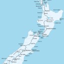
Three years after completing the North Island section of Te Araroa (“the long pathway”) Geoff Chapple tackles the South Island component of his proposed Cape Reinga-to-Bluff national walking trail.
A water taxi, its harsh little loudspeaker crackling out details of the various coves, islands and homesteads we were passing on the hour-long trip up Queen Charlotte Sound, finally delivered us to the jetty at Ship Cove.
Jump down, turn around. It was January 8, 2002, and I was at the northern end of the Queen Charlotte Track, the start of Te Araroa in the South. A happy barbecue crowd off the moored fizz-boats and yachts was already ensconced on the lawns. Those of us there to tramp picked our way through the holiday-makers and across a wooden bridge to look at the Captain Cook monument.
It was huge, white, stuccoed; and although it had the aesthetics of a tank trap I liked the thing. I liked the jaunty angle of the anchor at the top, the polished iron of the cannon at the base. Standing proud in brightly painted bas-relief, a blue sailor’s arm, severed at the shoulder in the heraldic manner, brandished the British flag. On the banner beneath were the words CIRCA ORBEM: around the world.
The scale of the monument stood in counterpoint to that of the bay—it was pocket-sized, which perhaps made it easier here than in any other of James Cook’s landing places to imagine those first British explorers of 230 years ago at their work. In 1770, Cook refilled Endeavour’s water barrels at a stream—it bubbles still to the left of the monument. His sailors careened the ship on gentle tidal slopes that still slope gently away. He raised the British flag on tiny Motuara Island—turning seaward, I could see the island, now a bird sanctuary, just a few hundred metres offshore.
This cove was Cook’s favourite New Zealand anchorage—he visited it five times on his three Pacific voyages. I had chosen it for the South Island start point of Te Araroa because its latitude—41º06’S—was slightly north of Wellington, an overlap that gave north–south continuity to the proposed trail. And it had historical cred.
The trampers wandered about, adjusting packs and posing for photos at the monument. I left them to it, setting off past the distance marker. The end of the track, at Anakiwa, was 72 km away.
I walked upward through a mix of fern, kawakawa and rangiora which could easily have been North Island bush, then, at about 100 m altitude, saw the first black beech trees. At Ship Cove, Joseph Banks, botanist aboard Endeavour, wrote in his journal of “the most melodious wild music I have ever heard”—the song of bellbirds—and as I reached the beech they were still there, the moss-green birds, gonging away.
I arrived at Furneaux Lodge, on Endeavour Inlet, in just over four hours, and found the manager, Stephen Western, looking out over the manicured lawns. In the 1950s, the old wide-verandahed homestead was offered to the government as a prime-ministerial retreat, but the offer was not taken up and the place fell into disrepair and some disrepute. Furneaux Lodge has been through whole cycles of growth and decay since then. Western, an ex-insurance broker who quit a thriving business in Takapuna two years ago having made a snap decision with his wife, Sue, and one other financial partner to take on the lodge, is engaged on its most recent revival.
“My dad died at 59 of a stroke,” he said. “My philosophy is this: call it the result of a midlife crisis if you will, but you look at the last 10 years of your life, and that’s what the next 10 years will be like if you don’t do something about it. If you don’t break the mirror, you’ll never see what’s on the other side.”
The dozen or so fellow trampers I was beginning to pass and repass on the trail were mostly holed up in Furneaux’s backpacker accommodation, The Croft. The big wet that dominated the first half of January 2002 had already begun, and everyone was trapped inside, talking the backpacker talk of Asian and South American adventures or reading books. Emma, an English woman, was engrossed in Lady Chatterley’s Lover; Jonathan, a recovering adman from London, was into The Lord of the Rings; Ariel, an Israeli, was reading Michael Shalev’s One Hundred Winters, about a Jewish family in Poland in the 19th century.
Ariel looked up, looked out: “I see why they call it the land of the long white cloud. The land of the never-ending cloud, I think.”
I was concentrating on a GPS manual. I’d bought the unit before setting out, and was trying to figure out how to enter track way points, a useful skill when walking unmarked mountain routes. The Queen Charlotte Track was a simple, well-marked, four-day path, so it seemed a good place to trial the thing, but the manual was incomprehensible. I needed to experiment, so I switched the GPS on. It began to beep. It couldn’t get enough satellites from the doorway, so I put on a coat and stood outside with it in the rain.
Next morning, the rain beat down and few of us moved far. People cooked their breakfasts, rearranged their packs, dipped into their novels. The next leg of the walkway, to Punga Cove, was no more than three or four hours’ hiking distance. Everyone waited for the weather to lift, but one by one became reconciled to the rain and went out into it.
An Australian woman cut arm holes in a black plastic rubbish bag, posed briefly for the rest of us—“A bit daggy, eh?”—and set off alone.
[Chapter Break]
Trampers Do not usually cross the Richmond Range north to south. The Alpine Fault runs parallel to, and just south of, the hills, and seems to have pulled a noble landform to bits. There are no good connecting ridges, and the interior is high and jumbled.
Trampers generally go in and come out, retracing their steps after a night in a hut, or stick to the two-or three-day tramps near Nelson or Richmond. To go right through is to commit to a circuitous route, to pack at least nine days’ food and to tramp around 125 km, almost double the distance of the Heaphy Track. It is also to rely on mountain-top tracks which the Richmond Forest Park map describes as “Extremely demanding in poor weather . . . not recommended for any but the most experienced and well‑equipped parties.”
Well, Te Araroa was going through, but felt in need of a companion. I phoned around, and Kevin Wills, a retired fireman and a Search and Rescue rep with the Marlborough Tramping Club, agreed to come with me. Two days into the hike we met a Japanese tramper, Tomonari Tanaka, and invited him to join us.
We climbed 1000 m through gradually dwarfing beech forest, and for the first time broke out into tussock, alpine daisies, snowberries and mountain weather. As we reached Starveall Hut, storm clouds were sailing in from the south and thunder began to roll around the tops.
Rain swept across the summits and cut us off from the rest of the world, but the hut, wired to the ground against high winds, was safe. With a fire it was also warm, and in the prevailing weather it aroused gratitude for shelter and for companions whose lives, in that place, seemed strangely potent.
Between squalls, Kevin glassed a faraway dot he guessed was Rintoul Hut, and sought to confirm this with map and compass. Tomo and I stood beside him, heard his mnemonic: “Good morning, sunshine—grid, magnetic variation, subtraction.” He lifted the compass off the map, lined the needle up north– south, and the bearing pointed straight
across empty space to the faraway hut.
Everything Kevin did had quality. The knots he used to bind two hiking sticks end to end to get the necessary aerial height for the mountain radio—professional knots. The porridge he set to soak in the pot overnight—it required less fuel to cook in the morning. He was organised.
Next morning we started early. The weather was clear, but we leaned into a biting southerly. We climbed through to Starveall’s 1500 m summit and descended to Slaty Hut, where we stopped long enough for a hot chocolate. Then we went on over the top of Slaty and up a tussocky ridge to the summit of Old Man.
We were tired and thirsty. There’d been no water since Slaty Hut, but the Outward Bound school, which exercises sometimes in these mountains, had wired a small open water barrel into place just below the ridge. Rainwater on tap, chilled by a southerly wind straight off the Alps, and Antarctica before that. I filled my mouth and held the water there, as cold and hard as a ball bearing, then let it liquefy and slide down my throat.
We were six hours into the day’s hike, and determined to make Rintoul summit and the hut that lay beyond. But now we began to labour over scree and to suffer true tramping pain. It looked as if someone had stood on the summit and bucketed vast tonnages of shingle down every side. To repel boarders, as it were. To deny you any purposeful striding towards the top.
It all starts cheerfully enough. Your boot takes its first step up the grey, granular, sloping stuff and immediately slides backwards. That step has rearranged the hundreds of bits of loose shingle underfoot but achieved little yardage.
Next boot, same result. Both boots are now immured ankle-deep in scree, and you have gone nowhere. If you splay your feet, you achieve greater traction, but the improvement is slight and you reduce a serious endeavour to something that looks alarmingly like a clowning routine. OK, so run at it. This is more red-blooded. Your left boot digs in before your right boot has time to complete its backward slide. Then the right boot digs in before the left has stopped sliding. It works, but it’s exhausting, and often enough, unbalanced by your pack, you find yourself unable to anticipate correctly the resistance underfoot and you pitch forward on your face—a second clowning routine.
The zigzag ascent, moving to and fro across the slope, works better, but your boots still tend to slip downhill, and the going is slow.
Finally you make opportunistic use of anything that works, including the occasional scramble on all fours. And always, you keep a sharp eye out for any scree more coarse than the viscous stuff underfoot, or any outcrop or ridge sufficiently boney to allow genuine progress.
The three of us climbed up the steep slopes to a 1640 m shoulder. I think we all nursed the secret hope that beyond this point a gentle connecting ridge would lead to Rintoul’s 1730 m summit, 1.5 km further on.
The connecting ridge was saw-toothed, precipitous, impossible. The poled route dropped away below it over broken rock, almost back to the bush-line. To reach the summit, we’d have to drop over 200 m then climb again—another 350-odd scree-strewn metres.
Dead legs climbed Mt Rintoul. Each of us took his own route. Each used his own psychology. Mine was to look for some kind of detail in the eternal broken rock. To stop. To look. To tell myself: I’m still enjoying this—this pattern of lichen here, whose subtle colours and patterns would make a useful batik. This vegetable sheep—so high, so alone. As vegetable sheep go, so small, but so determined. Ah—tenacious life, etc.
We regrouped at the summit and looked out over the immensity of the range, fold after fold of blue. Tomo handed out small, dense chocolate-chip cookies that he’d made himself.
The day’s tramp was not over. We crossed the firm, rocky mosaic of the summit and started to descend. Coming down scree is usually fun. You take huge strides, do ski-style turns, hoot and holler. But after 11 hours of slog the strength in your legs is unreliable. A leg may lock suddenly at the knee, may momentarily turn into a jolting stick that makes your teeth clatter, may threaten to bend backwards like the leg of a chook.
I descended slowly. Rintoul hut was 500 m down from the summit, well below the bush-line. It was late by the time we finally made it, heaving down packs that were wet with sweat and setting up the mountain radio.
At 8:30 P.M. on the dot, Paul Rennie, a power company linesman who operates a mountain-radio service from his house in Blenheim, called, giving us the weather and throwing in, as always, a bit of news. The Black Caps had beaten South Africa in the latest Tri-Series. Chris Cairns had whacked a couple of sixes.
The Black Caps! Out in the hills, cricket seemed a long way off. What was real was hunger. What was real was the flame as I fired up the Whisperlite to cook a meal. What was real was the cloud that had rolled over the hut, shrouding our world in mist once again.
[Chapter Break]
Te Araroa emerged from the Richmond Range at St Arnaud and pushed on into Nelson Lakes National Park: 20 km beside the Travers River, then up and over Travers Saddle, down into the Sabine, and over Waiau Pass—at 1870m, the second-highest point on Te Araroa’s proposed South Island route.
I boulder-hopped down the Waiau River. The yellow grassland spread wide in the sunshine. The river began to braid. The few things that moved emphasised the bright stillness of it all: the shadow across my path of a bird high overhead; a tramper on the far side of the river heading at high speed up the valley, too distant to hail, his hiking sticks working away.
On the valley sides I saw swathes of ghost forest—trees killed by slowly shifting scree. The more active rockslides remained bare, spilling right through the forest and out onto the shimmering grasslands like huge, grey, out-thrust paws.
There was no marked track, but as I picked my way down the valley I felt the invisible companionship of a thousand previous trampers. On an unmarked route you solve the problems of navigation in your own way, but surprisingly often as you come on, a discernible track opens at your feet. Those who have gone before have made the same decisions. There’s comfort in this, and I was always careful to walk where others had on that faintly pressed grass, where yet others would follow. A nascent trail.
I waded the Ada River, spotted the marker posts of the St James Walkway at the base of the next hill, and set off down that route. The sun was declining by then, but I hurried on. I wanted to get to a particular place before the light vanished—for Noel.
On the day Noel Sandford joined Te Araroa’s Waikato River trail construction project, we worked three hours then sat down for smoko. We talked rivers and tramping, and I told the story of an American I’d met who had tried to cross a creek in Westland when it was running. He’d lost his footing, his pack, his jacket and a fair amount of flesh from his legs, and been hospitalised for four days. “I believe if you die doing something you love, that’s the best way to die,” Noel said.
I looked at him. It wasn’t quite the coda for a story in which the tramper survived. “My wife was a keen tramper,” Noel continued. “She got swept into the Henry River while we were crossing a side stream. There was a flash flood. The whole bottom of the stream shifted. She was just this far from my outstretched hand.”
A hand’s-breadth.
I crossed the Henry River on a suspension bridge. The track followed the bank upriver, and then I came to a tream and a small cairn with the inscription: LOVE SPRINGS ETERNAL.
On January 4, 1994, Noel and Diana had tramped through to this point. The stream was in flood. Should they go upstream to cross? They went up for a look, but decided the existing ford was best. They grasped each other’s pack straps and began to feel their way across. The water suddenly began to rise further and they decided to abandon the crossing. They edged back. The stream was pulsing—a flash-flood phenomenon—and the streambed shifted beneath their boots. Noel saw a pressure wave and pitched forward on to it, hoping for, and finding, the big rock beneath. He was now the anchorman. The two remained linked, Diana using her husband’s supporting shoulder and arm to edge back to the bank. The water ran fast there, but shallow—just over boot height. That was his clear image. She was safe. He let go.
“I’m slipping,” said Diana, and fell backwards. A hand’s-breadth away.
Noel had one last sight of his wife, apparently pack-floating, caught briefly by an eddy in the Henry, smiling. One of the Sandford daughters, a doctor, took particular notice of this description and told her father later: “You shouldn’t worry that you could have done anything more, Dad. The reason she was smiling—Mum was already dead of cold-water shock.”
I knelt briefly at the cairn, shut my eyes and told someone I didn’t know that from what I’d been told her three daughters were doing very well.
[Chapter Break]
Always listen to a farmer. If he says the country is a bit rough, consider yourself warned. If lawyer even gets mentioned in that casual farming way, it won’t be the lawyer you’re used to, hanging here and there across your path through the bush, occasionally raking you as you pass. No. This will be serious lawyer.
The slopes of Mt Hutt were covered with fern and tutu, the latter a poisonous plant but not hard to move through. What was hard was the lawyer, rampant amongst the fern, thick-stemmed and with big thorns. I’d taken a bearing on the tollgate but I couldn’t hold the line. I simply went where it was easiest to go, up and down and around. It was unpleasant travel, but over long hours I made it through to a field below the gate. A bluff stood between me and it. The stream at the foot of the bluff was thick with gorse, willow and blackberry, all netted with creeper and lawyer. I diverted to a fence line, hopped over the gate—and struck bulls. They all swung round to have a look at me. One of them began to bellow—mwwwwAAAAAH!
Throughout my South Island hike, I’d been trying to compose a walking song. Walking, with its separate but complementary rhythms of swinging arms and striding legs, lung-filling breaths and soft, percussive footfalls, seemed to encourage composition. I had a mouth organ on board, which I sometimes broke out at the huts, though I’d never got much past the old repertoire—E Papa, Po Karekare Ana, Move Cecil, Silent Night and Jugband Waltz. Now, sidling along an electric fence in a paddock full of bulls, I broke into a slow but entirely spontaneous song:
“Let’s all take it easy”
MwwwwAAAAH!
“Let’s not be disturbed”
MwwwwAAAAH!
“Let’s all live together”
MwwwweeeEEEEEaaah!
“Here among the turds . . .”
I’m not going to call it art, but I sang and I hoped I was singing in a soothing register.
I kept facing the bulls as I moved along the fence-line, and as I sang I held my hands up, palms forward, and oscillated them slowly like a couple of metronomes. The musical form was dated, but this was not the time for hyper-rhythm, urban insults, four-letter words and the jabbing finger; this was pure Black-and-White Minstrel submission. Something a bull might understand.
It was a big field. The song went on and on, and so did the bellowing, but I hoped the beasts could see that we were locked into just such a primitive call-and‑response routine as might figure in the pastoral scene of a popular musical. That it would be a shame to sunder something we’d achieved together by any silly chargings or tossings.
I came to the fence I had to cross to get out of the bull paddock. It was a four-wire electric. You’re supposed to jump on to difficult fences like this, so your feet are off the ground when you grab the top wire. So long as you’re not earthed, you’re OK. That’s the theory, and it’s what I did: jumped on to it, hoisted myself up, swung a leg over the top, balanced myself with one hand on a post ready to jump down, and right then got a shock that would have felled an ox. I dropped like a stone, and lay on my back on the far side. The world receded into pale colours, then rushed back. But I was out and free and on my way to Mt Somers.
[Chapter Break]
Where was the hut ? I’d seen it on the maps and included it in the trail plan. At Department of Conservation headquarters in Twizel, I’d talked through the route with Mac McNamara and Ian Guthrie. The land had been retired to DoC, and with it an 1880s musterers’ hut.
“It’s dilapidated,” said Mac.
“Right,” I said. “But I’ll be able to sleep there.”
“If you don’t mind company,” said Ian Guthrie, grinning. “Might be better to sleep in your tent.”
Cold, white weather rolled down the valley, and the hurrying tramper was a speck in front of it. At every bend in the river he searched for the hut. OK, so there’d be rats. But you hang your pack from a hook and rats don’t worry you too much.
The hut wasn’t there, and then suddenly it was—concealed against the bank of a long river terrace, where I practically stumbled over its roof. Overgrown old brown beer bottles lay scattered about. I unhooked the door. It was jammed. I put my shoulder down and piled in.
One small louvre admitted a shaft of pale light. The framework and rafters were unmilled beech—thin trunks or branches, bark still intact, trimmed and whittled to fit. A rat skeleton was embedded in the dirt floor. Rum bottles lay all around, their labels foxed and lacy with acidic decay. Summer heat had softened a candle so that it had flopped in its holder like toothpaste from a tube and hardened there. The bunk bases were large-gauge chicken wire, with sacking mattresses, the kapok exploded out of them. The fireplace was a mound of solid ash held in place by sagging corrugated iron sheets. There was a table, with a skillet, and above it the only sign of order: three billies hung from nails on the wall—one big, one medium and one small.
It wasn’t the Hilton, but I was very pleased I’d made it in. I fired up the stove and put on the pot. I’d make myself a coffee. Shake up the milk. Break out the biscuits. Then put on the evening meal. A slow but steady pampering would take place.
The biggest billy, still hanging on the wall, suddenly boiled over. A thick, grey fluid poured out, flowed upwards on to a rafter, then sped along the central beam.
Maybe the cramped confines of the hut exaggerated the effect—the billy was only about a metre from my nose—but the hairs stood up on the back of my neck and I leaped back. The fluid had made it up into the rafters before I comprehended that it was a possum.
The creature hung there, its face turned away. The theory seemed to be that if it couldn’t see me, I couldn’t see it. The water began to boil and I poured it over the coffee bag. It’s one of the great pleasures of the tramp—a hard day behind you, dirty weather outside, and a hot drink cupped in your hands. But the hump of fur hanging over my head spoiled the magic. I took out my tramping stick, gave him a prod and made a suggestion: “Look, mate, why don’t you shoot through?”
The possum decided he was in a bad place. He climbed down from the rafter and holed up in the far corner of the top bunk. Fine. That was a good compromise. At least he wasn’t going to drop on me.
I began to drink my coffee.
HA-Ah-Ah-Ah-ah-ah-ah-ahahahahahah! TAT–tat-tat-tat-tat-tat-tatatatatat!
The possum hissed and spat. I whirled on him, stood up and pointed right at him. “Look, mate, don’t push it.”
HA-Ah-Ah-Ah-ah-ah-ah-ahahahahahah! TAT–tat-tat-tat-tat-tat-tatatatatat!
“I’m bigger than you. I’m stronger than you.”
HA-Ah-Ah-Ah-ah-ah-ah-ahahahahahah! TAT–tat-tat-tat-tat-tat-tatatatatat!
“I’m more intelligent than you are, and, in short, I wouldn’t do the big challenge if I were you.”
The possum began to walk across the chicken wire towards me. Bad move. His paws slipped through the holes and he was suddenly cast with all four legs ticking straight down. He looked up at me a bit like a man suddenly clapped in the stocks at the mercy of a leering crowd. Right in front of his snout were my possum-skin gloves. I hoped he’d
got the point, and left him to his own devices.
I drank my coffee and tried to establish the usual hut routine: drink, eat, sleep. It was coming on dark by now. I cooked up some pasta and tuna and ate. Now to sleep. The possum and I were not going to pass the night in the same room. Either he went or I did. He’d extricated himself from the chicken wire and climbed into the rafters again. I’d prodded him a few times, but he’d been unresponsive, and, to be honest, I felt like a bully. He wasn’t going to be shifted, and his claws were so deep into the beech wood I wouldn’t be able to prise him loose without wounding him.
Besides, I’d grown just a little affectionate towards him. A couple of things had softened my attitude. While he’d been bailed up in the corner, up on his hind legs and facing out, he hadn’t looked that different from a teddy bear sitting on a child’s bed. And I suspected he was very old. One eye was milky, indicating he was half blind, and, since he hadn’t heard me come into the hut and crash the pots, I presumed he was deaf as well.
Out of respect for the aged, and for my own comfort, I went outside and put up the tent. A couple of times during the night I was woken by possum racket. I could hear them moving about. More than one. I imagined a ring of them around the tent, paws linked, performing a triumphant haka.
I expected the hut to be empty by morning. I peered into the corners—no possum—and got on with preparing a muesli breakfast and shaking up the milk.
Right then I saw two ears sticking out of the big billy. Two pink ears. I felt a surge almost of affection. This was his turangawaewae, the place where he stood. He was too old, too set in his ways, to give it up. He wouldn’t be moved even by the threat of death. Well, good on him.
I felt a bond between us, and gave the bottom of the billy a few playful taps.
He rose up in immediate and raucous tooth-and-claw defence. This time he was staying put. He’d chosen to defend himself from inside his tin castle, and all through breakfast the pink nose, milky eye and nasty teeth hissed and rattled. I packed up as soon as I had finished and closed the door behind me, noting the loose piece of corrugated iron beside the door that served as a possum flap.
[Chapter Break]
We came up to the bullet-riddled sign at the bottom f the Little Baldy track. Unreadable distances to illegible places were stick-welded on to it, rusting away now, at one with the base metal. Arthur Williams and I were in the Longwoods, nearing the end of Te Araroa, and the weather was closing in. The Longwood Range rises long and low over western Southland. It is not obviously volcanic. Other South Island eruptions, such as the Banks and Otago Peninsulas, retain their skeletal craters, but they’re only around 12 million years old. The Longwood Range is 10 times older, as smooth as a rainbow, and has a good thing buried at its foot: gold.
Otago has captured most of the South Island’s old gold-field glamour, but the gold field at Round Hill, at the southern end of the Longwoods, was very big, and in the 1880s supported New Zealand’s largest Chinatown—300-odd Chinese. CAME UP to the bulletddled sign at the bottom f the Little Baldy track. Unreadable distances to illegible places were stick-welded on to it, rusting away now, at one with the base metal. Arthur Williams and I were in the Longwoods, nearing the end of Te Araroa, and the weather was closing in. The Longwood Range rises long and low over western Southland. It is not obviously volcanic. Other South Island eruptions, such as the Banks and Otago Peninsulas, retain their skeletal craters, but they’re only around 12 million years old. The Longwood Range is 10 times older, as smooth as a rainbow, and has a good thing buried at its foot: gold.
The gold was alluvial, so needed sluicing. That meant high-pressure water—plenty of it—and the miners looked to the Longwoods. Private entrepreneurs put up capital for races that could bring water from as far as 45 km away. By the time the main races had been planned, European mining companies had pushed out the Chinese gold-miners, but the Chinese dug the races, timbered them and put in the mile pegs.
The cloud drifted through the trees, the bush dripped and the track was a barely discernible crease. As we pushed through and began the climb to Little Baldy summit, Arthur started to whistle Sweet Molly Malone.
“You’re set to enjoy this, Arthur?”
“When you go tramping, you take what comes.”
The hillside finally opened out into tussock and dwarf trees. Spot the waratah. Visibility was down to around 25 m, there was no obvious track and the old steel markers were a good 100 m apart. We spread out, seeking that shadowy vertical in the mist that would lead us on, found it, fanned out again to look for the next one. It was easy to lose direction, but we both had compasses and I’d put a waypoint for the Longwoods summit into my GPS. It was 6 km away.
The way through was a labyrinth. The tussock trail was marked by waratahs, but thick clumps of flax, dwarf beech and mountain pine grew in haphazard corridors along the tops, and it became a game, albeit a serious one, to find the bush markers in this maze—the single bits of old Venetian blind nailed to trees, half-enclosed in moss.
There was Arthur whistling Annie Laurie. A sou’wester donned rakishly over his woolly hat. A bush shirt. Gaiters so old they were worn through. He’d been with the Southland Tramping Club for 25 years. He worked part time as a veterinary lab technician. And out on the Longwood tops, in zero weather, he whistled All Around the Blooming Heather.
We had a quick lunch and went on, breaking out into tussock again on a big undulating ridge. We lost the markers completely. I fired up the GPS. Longwood summit—that way. Even so, we nearly missed it, celebrating our arrival on the wrong knoll before finding the actual trig 50 m further on.
As we tramped away from the Longwood summit, the mist came down even thicker, and for the first time I was totally dependent on the GPS. We bent east, we kept bending east, and I had an uncanny certainty we were slowly completing a big anticlockwise circle. I waited for the Longwoods trig to loom back out of the mist, for the Pyrrhic victory of human instinct over the clever unit with the seven slave satellites. But then we came to the bush-line. We trawled along it, hoping to find a track marker, but the afternoon was drawing in and finally we just broke into the forest. The GPS unit was counting down the distance to a waypoint I had programmed in. A quarter of a kilometre, an eighth of a kilometre—we were bush-bashing, closing on it, but equally the forest was closing overhead, threatening to obliterate the signal.
Arthur shouted: “I’ve found it!” A track marker. A few minutes later we were at Martins Hut, shelter for the man, presumably Martin, who’d maintained the nearby water race in the old days. We slept soundly on historic hurricane-wire beds softened with sacking.
Next day we tramped south, following the best-defined and longest race in the Longwoods, Port’s Race. The Great Wall of China; the Great Ditch of New Zealand. A ditch 1.5 m deep and 1.2 m wide is not in itself remarkable, but we walked an hour in the tree-pillared, root-twisted New Zealand bush, and it was still unrolling beside us in its calm and constant dimensions. It was quite something. Not just the digging of it. It was still lined in places with timber, and totara mileposts still stood alongside the track.
One hour in, we came across a huge machine with the name Fraser & Tinne, Phoenix Foundry, Auckland, cast in the iron. Arthur laid respectful hands on its various parts.
“Six stamper rods. This is the cam. It lifts the rods to allow them to drop under their own weight into the mortar box.”
He parted some ferns and found a berdan, the rotating vessel with an iron-ball crusher inside that milled quartz even finer than a stamper battery. The reef mine there had been run by George Printz, an ex-whaler out of Riverton, but it had operated only a few years.
“The pay dirt ran out soon after Printz bought the mine,” said Arthur. “There were rumours it was salted.”
The track to the battery was a good one, not signed but well used by
locals. They came in here, but then they turned back, for from here on the track was notoriously rough.
We went on. I couldn’t believe it was too bad. The map showed that in the 10 km that lay ahead the race dropped no more than 40 m. There would be no ridges to climb, no steep hills to descend. The very nature of the race, slow-flowing so as not to scour its own channel, holding to the contour line, promised an amiable walk.
We tramped on and were soon lost again to the charm of the ditch. Bottles once bumped their way down its slow flow, carrying the race men’s mail for posting at Round Hill. Opium, too, according to one story I’d been told, came down from race man to race man. Perhaps you should doubt that one, but not the story of candles. Candles floating at night through the dark intricacy of the bush—who could resist the glory of that?
Everything I knew about the Chinese told me they’d have done it.
What the map did not show was that to stay on the contour line the ditch and the rough path beside it wound in and out of every small crease on the lumbering slopes of the Longwood Range. Ten kilometres? It was probably more. The hours went by, the ditch held mildly to its course and the light started to fade. Arthur whistled Jimmy Crack Corn.
We crossed totara slab bridges so old that grasses and a hundred tiny toadstools grew upon them. We reached the aqueducts which had carried the race over the two biggest creeks. A few trestles still stood, but mostly there was just wreckage, and we were forced to clamber down and cast around on the far side to find the way again. Big washouts forced us away from the race, and we had to scramble up greasy banks, or hand our way down steep faces, to get back to it.
We’d planned to leave the bush at a point where another old race crossed Port’s. That was the legal exit, but my GPS wasn’t working in the dense bush and we missed it. We kept on. Arthur was whistling Barbara Allan.
“Do you ever, like, enter whistling competitions or anything, Arthur?”
“No. Sometimes I get told to shut up, that’s all.”
Twilight turned to night. Arthur switched on his headlamp. I probed along with my torch. The darkness increased as our lights came on, but we hardly slowed. The bush began to do its witch-wood thing. Windfalls barred our path. Crisscross trees hooked us. Sedges hid the path underfoot.
“You know, when the track’s this bad, Arthur, it’s very good to have that dark canal alongside showing us the way. A big thank you to the Chinese labourers, don’t you think?”
“Yes. And thank you Charles Port.” Then Arthur gave a shout and disappeared.
He was hanging down the side of the race, roped there by roots, one foot twisted up behind him, and only slowly, by anchoring myself to a tree and extending a hiking stick to his outstretched hand, did I manage to tug him back on to the track.
We came finally to a fence beside the track. The race swung westward now, but it was time to bale out. We got to the square mesh of a deer fence and hung their briefly. We were still high up, and way below us a tiny cone of light went flat-lining by. The lights of Riverton glowed away to the east, and, closer in, we could see the highway lights at Colac Bay. I could smell the sea. In the darkness in front, a stag roared. Didn’t matter—we climbed the fence.
An hour later we tumbled into the Co-lac Bay pub, ordered up beers and a meal, and by degrees came to explain the mud, the blood and the still more sombre plan behind it all.
“And I thought you were just a couple of people from Riverton who’d lost their marbles,” said the Colac Bay pub owner, Dusty Duston, standing back, arms folded, and taking us in. “But this is something else.”
My South Island walk was coming to a close. Rounding Colac Bay towards Riverton, I stopped to chat with a photography group out on assignment from the Southland Institute of Technology. They gestured at the wide drifts of sand and stone, the surfers catching the wave. “Landscape,” said one guy with a topof-the-line Canon hung round his neck. “Incredible landscape.” As he said it I caught the flash of a stud in his tongue. I was approaching a city.
Storm winds swept Bluff as I arrived. My wife, Miriam, and two children had flown down from Auckland to join me. The wind blew out the marquee that was to be the hub of the Bluff Oyster Festival. It pinned the oyster boats to their berths. Down on the waterfront it bowled the Anzac Day wreaths away from the war memorial and strewed the remembrance flowers along the shoreline.
It was too windy for the Scottish piper I had organised, but a friend stepped in at the last moment. He was Irish, had a saxophone and played When the Saints Come Marching In. I stopped before a triple line of wind-blown children who sang a waiata, and I loved them for it. The kids parted and I moved toward the Stirling Point signpost. About then Invercargill mayor Tim Shadbolt arrived.
“Sorry, Geoff—a bit late, but, boy, do I have problems,” he said. “You try to organise a Bluff Oyster Festival when you can’t have it in Bluff and you don’t have any oysters.”
I reached past him and gripped the sign. “That feels just wonderful,” I said, and it really did.
And so my walk from Cape Reinga to Bluff ended.
There was only Te Araroa left to do.