Manukau Harbour
It is the larger of Auckland’s twin harbours; at high tide 340 square kilometres of sparkling sea, and at low water half of that, the rest becoming sand and mud-flats. The rugged heads can be glimpsed from many high points around the city and are one of the iconic images of Auckland for the millions of passengers who pass through the airport each year. For much of last century, this vast asset was neglected and abused, its waters a sluice for much of the city’s waste, but things are now improving.

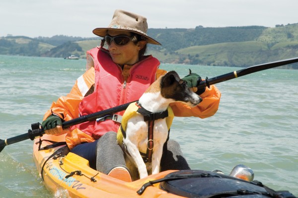
I heard someone yell, “Dolphins!” A small group of people were staring at a pod about 300 metres from shore at Jenkins Bay, a popular boat-launching site near Titirangi,in the inner Manukau Harbour. It was after 5 p.m. on a weekday and I was launching my kayak—part of my get-fit programme—hoping to work up a musclebuilding sweat. Instead, I was soon enjoying a close encounter with the sleek visitors from the Tasman Sea.As I paddled towards the dolphins, they joined me, and for the next half-hour I was surrounded by them—a dozen 3 m-long bottlenoses. One jumped clear of the water 20 m in front of the kayak’s bow, perhaps to help the pod navigate its way up-harbour. Another repeatedly dived beneath the kayak and surfaced directly in front. This was a little unnerving, for a collision could have tipped me into the water. Two dolphins were so close that I could touch them with my paddle. One smacked the water with its tail. Perhaps this was a signal for the pod to get serious about looking for some dinner, for they soon broke away from me and headed towards Onehunga. For me it was a signal to take my kayaking adventures more seriously. I determined never again to venture forth without a camera.
Some encounters with Manukau wildlife have set my heart racing. Several times, while paddling over shallow water off Little Muddy Creek, near Laingholm, I’ve startled a large ray. I haven’t been able see the animal but have felt the turbulent water beneath the boat as it has beaten its wings in hasty escape. Perhaps the weirdest encounter was when I unwittingly rescued a large weta that was floating on the water’s surface. It climbed aboard under its own steam and began exploring the kayak’s interior. My legs were included in the inspection, a disquieting experience. I used my paddle to shepherd it onto the bow, where it accidentally fell back into the water but immediately climbed aboard again. I quickly made for shore, where I let it run free into the bush.
How had it ended up floating in the water? Perhaps it’d been caught out on a rocky shelf by the incoming tide. It isn’t hard to see how this might happen, for the area of sandbanks and shoreline flats exposed by a low spring tide can be about 145 sq km, large enough to contain a small city and almost half the harbour’s high-tide surface area of 340 sq km. The vast expanses of mud and sand laid bare at low tide provide good foraging for gulls and other sea birds.
You really get to appreciate the dynamic nature of the harbour when paddling out to a sandbank. On an incoming tide there is usually a sudden improvement in water clarity as you cross into a tidal current: the murky, brown inshore water abruptly gives way to the blue-green water racing up the channel from the Tasman. I have occasionally beached my kayak to do some fossicking, but I never turn my back for long as the rising tide can steal your craft in minutes.
[chapter Break]
Between 45 and 65 per cent of the Manukau’s water squeezes through a harbour mouth that is only 2 km wide. The southern end of the Waitakere Ranges— remnants, originally submarine, of an eroded offshore volcano that erupted about 20 million years ago—forms the north head. In contrast to the dark volcanic conglomerates of the cliffs there, the harbour’s south head lies at the tip of the 35 km long Awhitu Peninsula, formed from sand dunes, some over 100 m high, that have accumulated and consolidated over the last one million years.
Powerful tidal currents surge past Paratutae Island, a rocky headland on the north side that becomes cut off at high tide, at speeds of up to 7 km/h in a narrow channel reaching 50 m deep. An arterial network of such channels transports the tidal flow to the upper harbour. One, the Wairopa Channel, which runs along the Manukau’s northern side, is used by fishing boats to reach the wharf at Onehunga.
These channels were river valleys during periods of global cooling, when much of the Earth’s water was locked up in the polar ice-caps and sea levels were much lower than they are today. A Field Guide to Auckland, by Cameron, Hayward and Murdoch, describes Auckland’s geological past and directs the reader to evidence of some of the great events that have shaped the region.

The Earth has been exposed to 30 cycles of cooling and warming in the past two million years, and the coldest stretch in the most recent glacial period was 18,000 years ago, when sea levels were 110–120 m lower than at present, glaciers and snowfields covered the mountains of the North and South Islands, and dry land connected Wanganui and Golden Bay. The seashore on the eastern side of the Auckland “isthmus” lay over 100 km from where central Auckland stands today, beyond Great Barrier Island, while the west coast lay 25 km out to sea from the present shoreline.
The land then was covered in forest, evidence of which can be found on tidal flats at the end of Renton Road, near the runway at Auckland International Airport. Giant logs and stumps, some up to 3 m across, rest in the mud. The trees of which they are the remains were mature when they died, probably drowned in a peat swamp. Gum and leaves preserved in the peat suggest the trees were kauri and tanekaha. The sea keeps the logs waterlogged, and this has helped to preserve them.
Heavily eroded cliffs along the coastline provide evidence of the death of a second, younger forest buried in ash from the eruption of nearby Maungataketake, oldest of Auckland’s almost 50 volcanoes. The remains of this extensively quarried volcanic cone, formed about 40,000 years ago, can be seen from the car park at the end of Renton Road. Near the base of one section of cliff, logs and whole tree trunks in growth position protrude. Cylindrical holes in the cliff indicate where branches and logs once buried in the volcanic ash have rotted away.
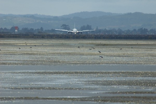
Walking out across the intertidal flats, one leaves the stumps and peat behind as the substrate becomes sandier. In places, the surface is covered with empty bivalve shells. There are also numerous delicate tubeworm casts, formed from cemented sand grains. Depressions in the sand indicate where large stingrays have been hunting for food. The rays settle on the sand, then blow a jet of water downwards to expose buried shellfish, including pipi and other bivalves. Mangroves line the shore, and wading birds scour the shallows for dinner. Behind, a roar reverberates over the flats as a 747 takes off, flying westwards over Papakura Channel, one of the Manukau’s deep-water arteries.


Tidal currents in the channels transport nutrient-rich water from the Tasman into the harbour. Apart from large floating jellyfish, most of what washes in is inconspicuous, yet once the sun sets, the surface becomes a busy place as tiny shrimps rise from the bottom to feed on plankton.
When I was collecting plankton by night from the Cornwallis wharf one night, my net was outlined in the dark water by microscopic luminescent phytoplankton. Larger creatures trapped in the mesh included mysid shrimps less than a centimetre in length and some jelly-like ctenophores. Diving beneath the wharf revealed numerous anemones and crabs, decorator crabs in particular. These creatures festoon their carapaces with colourful sponges and strands of seaweed for camouflage. Glass shrimps hide in the shadows beneath the wooden cross-braces.
Many creatures make their living by filtering the water, including barnacles, scallops, fan worms, oysters and mussels. Conspicuous amongst the filter feeders on the bottom are giant horse mussels, which are about 250 mm long but protrude only a few centimetres from the sand. Their scaly shells provide juvenile fish with barriers to hide behind, and form oases of firm anchorage amid the shifting sand for sponges and the like. When they die, their gaping shells make good homes for any smallish creatures, such as blennies or crabs, that can fit inside.
Under the wharf, care must be taken to avoid being hooked by fisherman above. A good strategy is to remain directly underneath, but this requires careful navigation from pile to pile, no easy matter in conditions so murky that visibility is much less than the distance between piles. Navigation is further complicated by the strong tidal currents that sweep under the wharf.
[Chapter Break]
Scuba Diving further out in the channel can be dangerous. I discovered this early one summer evening while helping Michael Richlen, a marine researcher from Otago University, to retrieve and replace a dolphin-listening device called a POD, or porpoise detector. Michael explained to me that, “a POD is simply a hydrophone, computer hard drive, and battery pack with enough power to run the unit for up to a month and a half”. The POD doesn’t record continuously, it only records sounds within a specific frequency range so as to maximise storage space and battery life.
Michael was conducting a pilot study into the possible presence of Maui’s dolphins, the world’s rarest and most endangered marine dolphin. Maui’s dolphins use echolocation—high-frequency sound signals—for navigation and hunting. Unlike most other toothed whales, however, they don’t whistle but “click”, at around 125 kHz. This is approximately double the frequency of the bottlenose dolphin’s click, and six times higher than the upper end of human hearing.
High-frequency sound doesn’t travel as far underwater as low-frequency sound, so Maui’s dolphins’ sonar clicks may be an adaptation for stealth, to avoid detection by predators such as killer whales. Unfortunately, dolphin sonar cannot prevent entanglement in set nets, which can trap the animals beneath the surface and cause them to drown. For this reason, in 2003 a ban on set nets within 4 nautical miles of the North Island’s west coast from New Plymouth to Kaipara Harbour came into effect. The ban extends into the Manukau as far as Puponga Point, near where we were diving. As well as investigating whether Maui’s dolphins inhabit the harbour, Michael’s research aims to determine if they are to be found beyond the current set net boundaries. The species is thought to number fewer than 150 individuals.
Kitted out in our dive gear, Michael and I sat on opposite sides of a semi-rigid inflatable boat, tied to a channel marker in a spot where the Cornwallis Peninsula amplified the treacherous tidal current. On the count of three we both rolled back-wards into the water. Visibility was typical for the Manukau: less than a metre. This was our second POD-replacement dive, and we had little time to complete the job, for the very brief period of slack water between tides had passed and the current was picking up speed.
We kicked hard across to where the POD was tethered. Once we were there, Mike had the more strenuous role of removing the invertebrate growth, untethering the POD and installing its replacement, which I simply passed to him. Fortunately, I had remembered to wear gloves, for I had to hang on to whatever I could to avoid being carried away on the tide. On an earlier POD-retrieval mission I had torn my skin on the sharp shells of Pacific oysters and horse mussels.
After the 10-minute operation, we were both exhausted. The POD had been in the water for about two weeks and, so we hoped, had recorded dolphin visits. Mike downloaded and interpreted the POD data using purpose-built software. The data must be studied carefully, since PODs pick up many “click events” not attributable to dolphins—from boat echo sounders, propeller cavitations, even just the movement of sand and debris in the current. Results over several months have now confirmed the movement of Maui’s dolphins within Manukau Harbour beyond the set-netting boundaries.
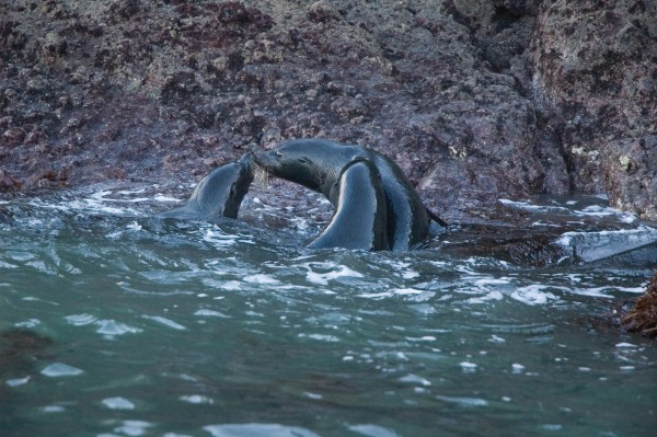
Other animals at the top of the food chain visit and live in the harbour. Fur seals use it as a base during winter. I have often seen a black fin or nose protruding above the water’s surface, but seals are very shy and will usually dive and swim away if approached. There is a colony at Waterfall Bay, towards the heads, and I believe that the seals there use the Manukau’s strong tidal currents to commute into and out of the harbour. I have observed one lying on its back in a strong flow, travelling out through the heads. Seals have also been seen up-harbour, near the Mangere sewage-treatment plant.
The colony is located beneath the rocky cliffs that line the northern side of the harbour entrance, between Paratutae Island and Little Huia. Getting to it by kayak requires some planning. The area is exposed to the south-westerly wind that can blow off the Tasman Sea, so you can’t go there if this is strong for it drives in a big swell. Light winds from the east and a low tide are desirable. At low tide the Manukau Bar helps to block the swell from entering the harbour. Currents near the heads are powerful, especially around headlands, and swells can suddenly grow in size, particularly when water and wind oppose each other. Stay close to the shore, however, and you run a good chance of being dive-bombed by seagulls when they’re nesting.
On one memorable trip, I set off from Little Huia with some friends to visit the seals at Waterfall Bay. Half a kilometre from the colony we could smell the leftovers from countless fishy meals. On arrival we counted 11 seals. I slowly paddled across to photograph one that was basking on a rock. A light south-westerly swell was lapping the rocks, and by turning my back to the sea, laying down the paddle and holding up my camera, I put myself into a dangerous situation. A rogue wave came without warning and thrust my kayak forward. The seal I was photographing growled at me like a big dog as the bow went under the overhang of his rock. I realised that another wave would jam the bow and I might be tipped into the water, camera in hand. I could almost smell the seal’s breath as I stowed the camera and back-paddled away.
The seal colony and sea-floor at Waterfall Bay are surveyed three or four times a year by the Western Underwater Research Team, a group of about a dozen divers. Within a roped-off 500 square metres, they conduct fish counts and are on the look-out for anything unusual. The fauna there is quite colourful, with numerous gaudy sponges, ascidians, nudibranchs and crustaceans. Kelp fringes the shoreline. The survey has been going for about 10 years. Team leader Mike Percy told me that the maximum number of seals observed at Waterfall Bay on a single occasion was 17.
We left the seals and made our way further along the coast, to the harbour entrance at Paratutae Island. The tidal current was weak, being on the turn and about to begin filling the harbour; however, the turbulence of the water as it passed the island was remarkable. Upwelling currents spread outward in ripple-free patches, oily smooth in appearance. It was as if my kayak was in the grip of a giant washing machine. Periodically, as I dug my paddle into the water I would experience little or no resistance, having entered an eddy in which the water was going with the paddle.

It’s a little unnerving to go diving in a place like Waterfall Bay, for fur seals are preyed on by big sharks. Many of the sharks on display at Kelly Tarlton’s aquarium on Auckland’s Tamaki Drive were caught in the Manukau. I wandered down there to find out more about them and spoke with curator Andrew Christie.
“We collect sharks in the Manukau at certain times of the year,” he told me. “We can catch broad-nosed seven-gilled sharks from August to mid-November, and bronze whalers appear between October and late January.”
I asked him how long these sharks could grow, and he replied that a large female seven-gilled shark reached 3.5 m in length—about the same as my kayak. These predators have been known to pack-hunt cetaceans and other large animals. Andrew recounted how a regurgitated seven-gilled shark meal in the aquarium included pieces of turtle and fur seal. Other sharks that visit the Manukau include small school sharks and dogfish. In summer, hammerheads can be seen basking on the surface. Great white sharks are known to frequent the waters thereabouts, and mako sharks have been seen swimming inside the harbour mouth.
Sharks caught for the aquarium are manoeuvred onto a stretcher alongside a boat and then lifted into an 800-litre tank in which oxygenated water is circulated across their gills. From capture to release into the aquarium takes two hours. A new arrival is transferred to a recovery pool, where it is “walked” by one of the aquarists; then, when ready, it is introduced into the shark tank accompanied by divers to guide it round its new surroundings.
[Chapter break]
The aquarium occupies the site of Auckland’s old sewage-holding tanks at Orakei, which were decommissioned when the Mangere Wastewater Treatment Plant, near Puketutu Island, in Manukau Harbour, began operations in 1960. I contacted Watercare engineer Richard Lawty to learn more about the Manukau’s role in Auckland’s wastewater treatment. He told me that during the first half of the 20th century there had been public concern both about pollution of Waitemata Harbour by sewage from the Orakei outfall and about air pollution from heavy industry round Mangere Inlet, the north-eastern corner of the Manukau, where chemical discharges, along with offal from the Southdown and Westfield freezing works, were turning the mud flats into a haven for sulphur-loving bacteria. The bacteria were generating hydrogen sulphide gas, which blew off the flats and reacted with lead-based paint on the local houses, turning their predominantly white weatherboards black with lead sulphide.
The sheer volume of waste pumped into the harbour was staggering: it is estimated that by the mid-1950s, 25,000 cu m of trade waste and 675 cu m of untreated domestic sewage were being discharged daily into the Manukau. This is equivalent to the volume of about seven Olympic swimming pools. The situation improved dramatically following the establishment of the Manukau Wastewater Treatment Plant in 1960. The plant’s oxidation ponds, between Puketutu Island and the Mangere foreshore, covered 5 sq km and used sunlight, air and bacteria to break down the waste. The plant took a huge environmental burden off Mangere Inlet, allowing it to recover.

Gone was the hydrogen sulphide, but in its wake a new problem arose: midges and awful smells from the oxidation ponds. These lasted until 1964, principally because it took that long for the bacterial breakdown process in the oxidation ponds to stabilise, and while it did so the nutrient-rich water provided an ideal environment for the hatching of midge larvae. The problem became so bad that locals had to use brooms to sweep dead midges off their doorsteps. Once the ponds were working properly, however, the smell disappeared and the water in them became toxic to midge larvae.
There were no major hiccups for the next 10 years, but in the mid-1970s the smell returned as a result of Auckland’s population outstripping the plant’s capacity. By 1987 a push to upgrade the plant was gathering strength, and this culminated in its transformation, beginning in 1998, from a pond-based to a land-based facility. Work also started on the de-sludging and restoration of the pond sites.
In the new land-based process, solids are removed from the sewage and stored on land. The wastewater is denitrified in stages, and disinfected, by the world’s largest ultra-violet-light-treatment plant. The treated wastewater is collected in a reservoir between Puketutu Island and the mainland, and a daily average of 300,000 ku m is released into the harbour on the outgoing tide through five giant submerged pumps. Since its inception, the plant has been the Manukau’s biggest “river”, and it is claimed that the new process has substantially improved the local environment and the quality of the effluent water.
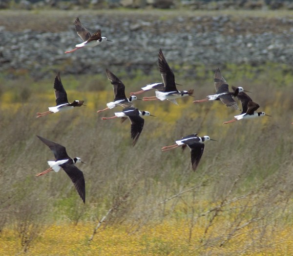
Certainly there is little smell, although I could detect a slight odour coming from the bio-solids landfill operation on the site of one of the old oxidation ponds. Birds are everywhere. Groups of pied stilts hunt in the new marshland above one of the former ponds. Ducks and ducklings swim in the canal that holds the treated water. Richard told me that some of the birds migrated here from as far afield as Alaska and Siberia, and that 25 per cent of the wading birds in the Manukau visited the Mangere area of the harbour. Things are looking pretty good, but can we quantify the improvements?
Dr Hugh Grenfell, an Auckland geologist, told me that we could learn a lot from studying the tiny shells of creatures such as crustaceans and foraminifers, collectively called microfossils, extracted from short cores of harbour mud. Foraminifers can be considered amoebae with shells. Many are too small to be seen without a microscope but there are significant exceptions. The Egyptian pyramids were built from a type of limestone that contains giant fossil foraminifers, called nummulites, about the size of a five-cent coin. Foraminifers are abundant in most marine sediments, and Hugh and his colleagues have driven hollow tubes into the harbour mud to obtain cores.
“The nice thing about this is that you can see and date changes down the core by studying the quantities and types of foraminifers and other microfossils that are embedded at each level. You can do this at a number of sites and get information across an area of harbour that tells a story.”
The study has focused largely on the upper harbour, near Mangere, Onehunga and Puketutu Island, where the high human population puts the environment under greatest pressure. It has traced changes from pre-Maori times (over 700 years ago) to the present.
“Maori don’t appear to have had any significant influence on sedimentation rate or the foraminifers in the sediment,” Hugh told me, but with the arrival of the early Europeans “we have seen a sudden increase in sedimentation and other changes.”
Has the wastewater treatment plant improved the environment? “In the Mangere Inlet, we have seen improvement, although there has not been a recovery to pre-European conditions.”

I asked if there were any new threats to the Manukau environment, and Hugh told me that urban storm-water run-off into the harbour was a problem. Rainwater that falls on roofs, streets, footpaths and driveways is fed directly into the harbour by stormwater drains rather than being soaked up by the land. This can reduce the salinity of the harbour, while the run-off carries many pollutants with it, including zinc and copper, which are toxic to marine organisms.
Has this had a measurable impact on the harbour? We don’t know yet, but Hugh and his colleagues have observed that in the Tamaki and Riverhead estuaries, in neighbouring Waitemata Harbour, salinity changes since early European times have significantly altered the abundance of bivalves and other estuarine creatures. Without controls on storm water, numbers will not recover.
[Chapter Break]
Is The Manukau silting up? I posed this question to Simon Thrush, a scientist at the National Institute of Water and Atmospheric Research involved with a harbour-monitoring study that has been running for 20 years. He told me that the situation looked good for the main harbour channels, which were flushed by tidal currents and wave action, but that backwaters such as harbour creeks and bays, which supported mangroves, were becoming shallower.
Simon has compared 50-year-old aerial photographs of the harbour with recent ones, and it is clear that mangroves are spreading. Urban development seems to encourage their expansion, possibly by adding silt and nutrients to waterways as land is cleared for building, creating the shallow, muddy conditions in which they flourish. Once mangroves become established they create their own micro-environment, damping down current and wave action and allowing more sediments to settle.
Simon’s group also monitors the Manukau’s ecology, and their data reveal the main body of the harbour is generally healthy. One species that grows well in the tidal creeks is the Pacific oyster, an invasive species that arrived from Japan sometime in the late 1950s. It is now served in some of New Zealand’s best restaurants. While the Pacific oyster prefers a muddy habitat, scallops live out on the more exposed sandbanks. In common with most edible species, the biggest threat they face is overharvesting.

How’s the fishing? Harvey Waite of Titirangi, who has lived by and fished the Manukau for almost 70 years, told me. For 10 years he fished commercially, and for 13 years served as an honorary fisheries inspector. In the old days, he said, “fishermen did everything in a punt that you rowed”. If you were based in Huia, you couldn’t get much beyond Cornwallis in a day. But fishing practices started to modernise in the 1980s. Nowadays fishermen can go around the harbour twice in a day, moving quickly to wherever the fish are running. There are also a lot more people on the harbour now than 20 years ago. Kahawai, trevally, gurnard and flounder are still easy to catch if you know what you’re doing, but snapper are harder to find. The biggest snapper Harvey has ever caught weighed 10.5 kg, and in the old days it was common to come back with a 6 kg fish.
He remembers the days before sewage treatment. There were structures for holding raw sewage at Green Bay, and the sewage was released on the high tide. It seemed to be good for shellfish, as there were a lot of scallops and pipi around at the time. Perhaps in those days household sewage was more organic, with less detergent and chemical waste. Overall Harvey feels that the harbour is improving. In his own words, “the Manukau is picking up good”.
There is no doubt that humans have had a harmful effect on Manukau Harbour, as on many other inlets and estuaries. But with our increased understanding of and concern for the marine environment, we are well on the path to restoring it to something like its former state. The future looks bright, and this is a good thing not just for marine life but also for us and our descendants. Long may the harbour remain a suitable stopping-off place for dolphin visitors from the Tasman.


