Finding Whangaroa
Old traditions, new beginnings in Northland’s historic harbour.

From the top of the Duke’s Nose—a soaring volcanic parapet with gobsmacking views across the mouth of Whangaroa Harbour—the sea beyond the harbour heads looks benign and beckoning. But an hour later, in amongst it at kayak level, I find I’m being churned in a washing-machine chop. It’s shallow out here, despite being on the open coast, and with an outgoing tide and onshore wind the waves are brutish and steep.
My kayak hull smacks down hard in the troughs, and the crests slop over the deck. Perhaps I am like the one Robin Hyde wrote about in 1937 in her poem ‘Whangaroa Harbour’—him whose hopes ride out too far, On great white horses to a towering noon. But I can see calmer water a few hundred metres away and paddle hard to reach it. Soon the sea changes colour to the darker blue of deep water, and the whitecaps ease. I can pause, catch my breath and look back at where I’ve come from.
I have spent the day paddling around the harbour to get a feel for the geography of the place. What I’ve felt are the big earth-shaping forces that forged the dramatic vistas for which Whangaroa is famous: volcanic crags that thrust skyward through dense native forest, conglomerate boulders whittled by the sea into “mushroom rocks”—strange shoreline sculptures with skinny, fragile stalks—and a crazily indented coastline with so many bays it would take a fortnight to explore them all.
According to geologists, Whangaroa Harbour is a collection of drowned river valleys. They say it has probably been emptied and filled 20 times over the past two million years, as sea levels have risen and fallen, sometimes by more than 100 metres.
Now, as I bob in the swells, I see that the harbour entrance has vanished into the hazy coastscape of black rock and forest. If you were travelling the coast for the first time, you would probably miss it entirely. The entrance is a scant 300 metres across, and the south head protrudes into the harbour behind the north head, blocking the view inland. Captain Cook missed it, and the first visit by Pākehā wasn’t until 1807, when a sealing ship named Star found its way in.
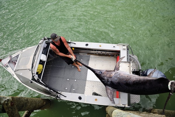
These waters are famous for gamefish. Along with the Bay of Islands, Whangaroa was a famous swordfishing destination in the 1930s. Dubbed “marlin capital of the world”, it is still a magnet for anglers wanting to do battle with a billfish—or a tuna or shark.

Māori knew these ara moana intimately, these paths of the sea. They knew the food resources they held, and they knew their changeable moods. Caves on each headland at the harbour entrance were said to imprison the winds—the west wind in one, the east wind in the other, both capable of breaking out of their confinement and unleashing their fury.
Today, Tamatane, the east wind, gives me a boost as I paddle back into the harbour. As I pass Waihi Bay, I look up to see if I can make out the face of Kaimohi in the rocks. According to legend, Kaimohi had been away a long time, and his wife, Rauruiti, missing him deeply, said, “Ka roa au i whāinga”, I have longed for this return, from which “Whāingaroa” derives. One day, while gathering pipi, Rauruiti chanced to look up and saw her husband’s face carved in stone, looking north to Cape Reinga, the departing place of spirits. She immediately knew he had been killed. As was common practice for the wife of a rangatira, she climbed a cliff and cast herself from the top, so that her spirit might join her husband’s on the journey back to Hawaiki.
Some say the landmark twin rock domes of the harbour are parts of her shattered body—Ohakiri (St Paul), on the eastern side, is her knee, and Hopekako (St Peter), on the western side, is her hip.
Postal mix-ups with another Whaingaroa Harbour, in the Waikato, led to an administrative decision to drop the “i”. Over time, the Waikato harbour became Raglan, so Northland’s Whangaroa could have kept the letter after all. Some from the local iwi are pushing to have it reinstated.
I paddle beneath ancient pōhutukawa whose branches bend down to kiss the water, past sheep farms and oyster farms and the orderly rows of pleasure craft in Whangaroa marina. It’s late February, and there’s a national gamefishing contest in progress, but you wouldn’t know it. The place looks deserted.

Two centuries ago, this area was a centre of political power in the north. Today, it’s the centre of not much at all. Like much of the Far North, Whangaroa is somewhere time has passed by. It is easier to discover a glorious past here than to envisage a prosperous future. But that’s not to say the locals aren’t trying. A community development plan released in 2011 has as its vision statement that Whangaroa is “a thriving, harmonious, self-directed, culturally-diverse community that cares for, and is sustained by its unique natural environment and heritage”.
Realising that vision may not be easy with a declining population (3000-odd and falling in the larger Whangaroa area) for whom the median income ($17,700, according to the plan) was just over half the national average. Although the community goals emphasise social wellbeing over economic growth, the plan recognises that a diversified economy is essential, and proposes ventures as disparate as beekeeping and seaweed farming, houseboat tourism and a campervan trail as options worth pursuing.
It is the last item on the wishlist that intrigues me: heritage. How does a place like Whangaroa build a flourishing future on the foundations of the past, connecting the dots of heritage and opportunity? It’s a challenge that much of small-town New Zealand faces, and for which there seems no ready-made solution.
[Chapter Break]
You can walk through Kaeo, the Whangaroa district’s main town, in two minutes, from the police station at one end to the volunteer fire brigade’s base at the other. Five minutes if you include the schools—a primary and a secondary—and a four-wheel-drive wrecker. The main road, Leigh Street, named after a Wesleyan missionary of the 1820s, has been absorbed into State Highway 10.
Roading is partly to blame for Whangaroa’s socio-economic eclipse. From early colonial times, the coastal road through Kaeo was the main route north. Then a new road was built inland, through Mangamuka and over the Maungataniwha Range, and by the 1950s that route had become State Highway 1, while the coast road gradually became the scenic route. Even so, Kerikeri, 40 kilometres to the south of Whangaroa, and Doubtless Bay, the same distance to the north, have boomed, while Whangaroa has not. Soil fertility, availability of land for development, access to beaches and basic geology (much of Whangaroa is steep hill country) are factors in the region’s lopsided growth.
But in a way, Whangaroa benefits by being equidistant from both population (and employment) centres, while retaining its charm, its character and its quietness—qualities many residents prize.
Certainly, the locals don’t lack pride in their community, downsized as it may be. At each end of Kaeo a sign reads, in English and te reo: “Small town, big spirit. He wairua nui.” Outside the war memorial hall I spot another greeting, delivered with a dash of humour. “Welcome to Kaeo” is painted on both sides of a dinghy, and that dinghy sits atop a 10-metre-high pole—a reference to the floods that swamp the town at regular intervals.
Kaeo is built on a floodplain, so you could say that inundation comes with the territory. In 2007, there were three floods within five months. During the Great Northern Flood of 2014, the town looked like it was standing at the edge of a lake. In 2012, the town was in the lake, and floodwaters rose halfway up the petrol pumps.
There’s a certain irony in the fact that the town is named for a species of freshwater mussel. The shellfish are uncommon now, but I found a kete full of kaeo shells—dark brown, about the size of a tuatua—in a display at the Whangaroa museum on Kaeo’s main street.

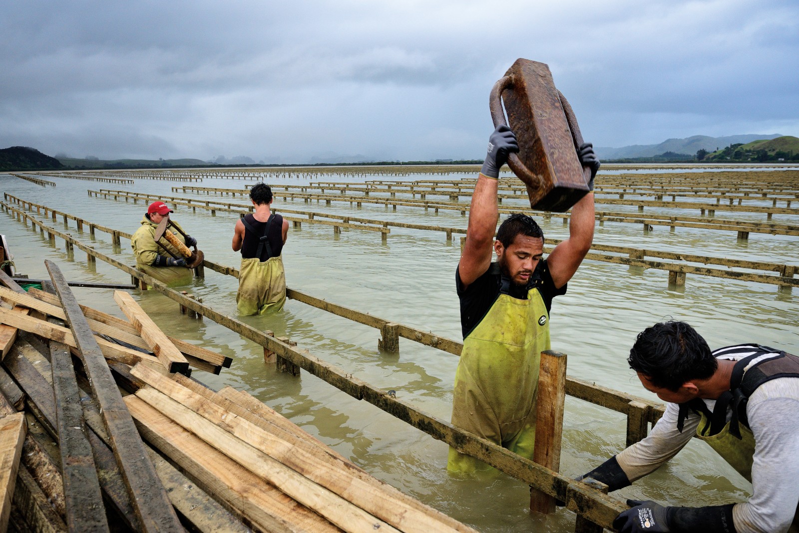
Kaeo may have disappeared from the streams, but the oysters in Whangaroa Harbour are prospering—or they were until they were hit by a disease in 2010. Oyster herpes, a virus, swept through oyster farms and wild oyster spat-collecting areas in the North Island. Oyster production was halved. Some farms lost their entire stock of juvenile oysters. Mortality of oyster spat was as high as 90 per cent in some areas, and Kaeo’s largest employer, Sanford’s oyster-processing plant, was forced to shut.
The disease had already decimated oyster stocks in France and the United Kingdom, and subsequently spread to Australia. In the Hawkesbury River, near Sydney, the virus is said to have killed 10 million juvenile farmed oysters in three days. “Herpes is killing nature’s most popular aphrodisiac,” a waggish blog headline reported.
“The industry was in crisis,” Garth Richards tells me. We’re standing in the rain, in the pre-dawn darkness, getting ready to launch his aluminium boat and motor across to Pacific Marine Farms’ oyster farm, which spreads over a large portion of mudflats at the head of Whangaroa Harbour. Richards is the farm manager.
“The industry thought Pacific oysters were bulletproof,” he says. “Turns out they weren’t.”
When the virus struck, the first imperative for big oyster farms like Pacific Marine was to move away from capture of wild spat to production of more costly hatchery spat. Then the company teamed up with Nelson’s Cawthron Institute to try to breed disease-resistant oysters. But the virus is not the only challenge for the industry—it’s dealing with an image problem too.
“If you’re a millionaire owner of a bach on the hill up there and all of a sudden you look out on an oyster farm, you might think, ‘I don’t really want to see that. I’d prefer my yacht to be anchored out there.’”
We’re drifting between the rows of oyster racks while a maintenance crew—they look like an aquatic chain gang—wade alongside, pulling out worm-eaten timber, throwing it on a barge and ramming in fresh stakes. I get the impression Richards isn’t that interested in the preferences of bach owners and their yachts. “Oysters take out tonnes of nutrients from the harbours every year—nutrients that have flowed into the sea from the land. We see ourselves as contributing to the harbour’s health.”

That’s a view not universally shared. “Protect our harbour. Toxic mining? Fish farms? Jobs?” reads a sign on Kaeo’s main road. Over the past decade, residents have lobbied the Northland Regional Council to establish a maritime park in the harbour and adjacent coastal waters, but without success. In 2013, three of the park’s proponents took a case to the Environment Court, opposing the establishment of a mussel farm at Stephenson Island/Mahinepua, four kilometres off the harbour entrance in an area designated by the regional council as an “outstanding natural landscape”. The court found in favour of the mussel farm.
Terry Hassall, a retired civil engineer and one of the trio who lodged the mussel farm appeal, says Whangaroa is one of the last semi-pristine marine recreational areas left in the North Island, and the potential economic benefits of marine ecotourism to the region far outweigh those of aquaculture.
“Nowhere else in Northland has the attributes Whangaroa has,” he tells me. But preserving Whangaroa’s marine heritage in the form of a maritime park seems off the menu, for now.
[Chapter Break]
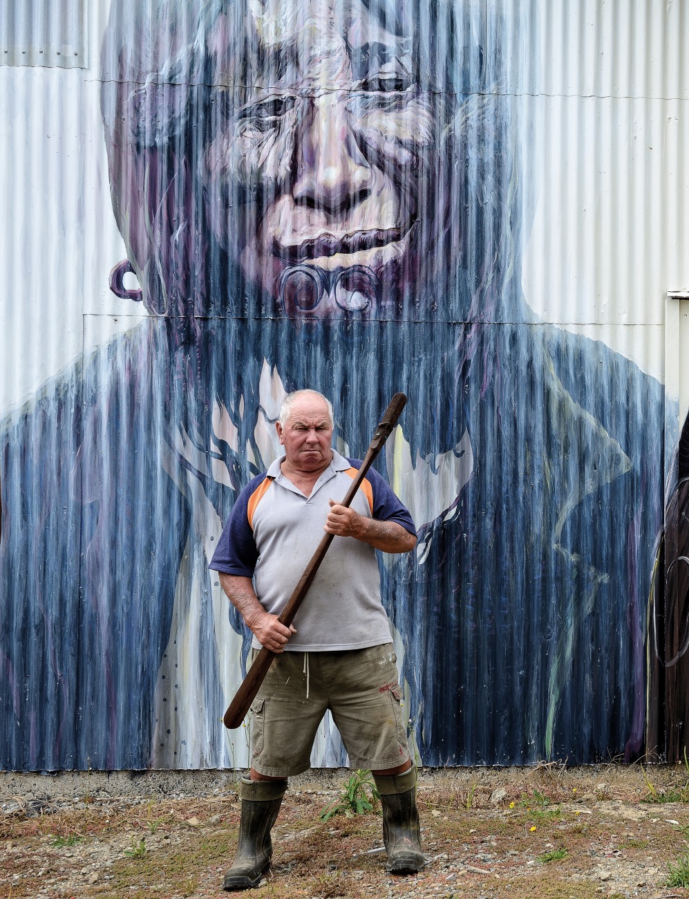
Richards drops me at the Totara North boat ramp before heading up the harbour to take his regular water samples for laboratory testing. I walk along the deserted road to see Whangaroa’s newest window on its past. You can’t miss Bruce Sanderson’s museum-in-the-making, due to open at the end of this year. The corrugated-iron buildings are painted with eye-catching murals of historic scenes: a record-breaking marlin being weighed at Whangaroa wharf, a gang of bushmen dwarfed by a massive kauri log, a portrait of a Māori woman with a taiaha—Sanderson’s great-grandmother, it turns out.
The murals are the work of Kaikohe artist Chris Wilkie, who has gained a reputation in the north for his skill in rendering historic scenes on corrugated iron. The nautical themes are close to Sanderson’s heart. Five generations of Sandersons have been crayfishermen in the area, from his grandfather through to his grandson. He himself fished 51 years in a row, he tells me proudly.
One of the buildings is a tool gallery, and he walks me through it—an astounding collection of the bizarrely practical and the practically bizarre. I’m much taken with a double-ended crescent spanner. Why didn’t this catch on, I wonder?
In keeping with Whangaroa’s history as a logging and sawmilling centre, there’s every size and style of crosscut saw you can imagine. The teeth of some of them are shaped like decorative finials—artistry from a bygone era.
Sanderson invites me across the road to his home. This, too, has been overtaken by the collection, which spills into an adjacent garage. “More junk,” he says. But it’s obviously not junk to him. “It all has a meaning,” he tells me. His collection of kauri gum is one of the strangest I’ve seen. He has native kauri snails carved from kauri gum, a loaf of kauri-gum bread with a kauri-gum bread knife, a kauri-gum man in the moon.
It’s hard to keep up with the parade of peculiarities. He shows me miniature paintings on fish scales. He demonstrates a telescopic drinking cup, which folds out from a disc of metal into a tumbler—“for cyclists”, he says. There are walking sticks with a knot for a handle. “You tie a tanekaha sapling in a knot, come back a few years later and you’ve got a walking stick.”
If, heaven forbid, the house caught fire, what single object would he rescue from the flames, I ask. He thinks for a moment. “The kauri-gum hair.” The what? He guides me to a cabinet containing a luxuriant plaited braid of blond “hair”—actually gum, melted, then spun as a chef spins sugar, drawing it out into fine threads.
“Do you know what this is?” says Sanderson, picking up a lump of grey metal. “It’s the lead from the Boyd.” He points out a hollow in the bottom which has a waxy substance inside. “Mutton fat,” he says, and asks me why I think there would be mutton fat on a device for sounding depths at sea. I’m at a loss, so he explains that the fat picks up sediment from the bottom, showing what kind of bottom the ship is sailing over: shingle, shell, sand.
A lot of ink has been spilled writing about the blood that was spilled in 1809 when the crew and passengers of the Boyd were massacred. That event still casts a shadow.
For the 200th anniversary there was a project to create a seating area on the Whangaroa foreshore overlooking the spot where the remains of the ship lie in a few metres of murky water. But some Māori were uneasy, wondering what purpose was served by a memorial to that grisly episode—plucking it from among a series of attacks and reprisals during a turbulent period of Māori-Pākehā relations.

Nuki Aldridge, a kaumatua and descendant of the revered rangatira Hongi Hika (who died of a bullet wound in Whangaroa in 1828), wondered why there was no plan for a similar memorial to mark the site where the village of Bay of Islands chief Te Pahi, an innocent party in the affray, was razed by a posse of whalers exacting retribution for the Boyd. It’s not the remembering he objects to, but the selectivity of it. The Boyd is in the frame, the slaughter at Te Puna isn’t.
I am sitting with Aldridge and Moana Wood, a kuia from Taupo Bay, in the old White Swan Tavern in Kaeo, now an empty building. Wood is a direct descendant of Te Pahi. “They’re jumping up and down about a boat, but they’ve forgotten about a whole incident that happened with our Nan,” she says, referring to her ancestor. “They chased him all over the country to try and kill him. They wiped out his village—men, women, children. Where’s the respect for that? If you’re going to stir up history, it can’t be just one side. So, yes, the Boyd is still quite sensitive for a lot of people.”
Talk turns to sunnier subjects. There’s a gleam in Wood’s eyes as she speaks of gathering kaeo from near a bridge where State Highway 10 now crosses the Kaeo River, and catching tamure, the large snapper that swam upriver to feed on the kaeo. “All the flat land between Kaeo and Totara North was swamp and salt marshes at one time,” she says. “I remember the eels there.” Aldridge sucks in his breath at the mention of those eels. Then history’s shadow intrudes into the story. When Pākehā reclaimed that land for farming, Wood says, “it took away the harbour’s filtration system and all the life forms that were living there”.
A similar shadow touches memories of summer months spent camping at Pekapeka Bay, near the harbour entrance, harvesting kai moana, gorging on wild peaches. Aldridge remembers those summers too—nikau huts and candle light—but in the 1960s, much of that area was designated a scenic reserve. “Suddenly we couldn’t camp there,” he says. A seasonal cycle of food gathering that had been in existence for centuries was terminated.
On the opposite side of the harbour from Pekapeka Bay, some of Wood’s tupuna kept a lookout for whales.
If a whale was spotted, a bonfire would be lit to alert neighbouring hapū. Each kin group had rights to specific areas of the sea, she explains. If a whale crossed the boundary, it became the property of another group.
“My grandfather was a harpoonist,” Wood says. “The rowers worked hard to turn the whale and keep it in their area, but if it crossed the line, my grandfather would cut the rope.”
“That’s the way they operated,” Aldridge adds. “You do all that work, and then you have to let it go.” Such an action—barely imaginable today—was entirely consistent with a communal subsistence economy, he says. But that economy was shredded by the European cash economy, which championed individual property and commercial gain.

Coming to terms with that new economic reality was a painful transition for Māori, eased a little by the generosity of some Pākehā, Wood says. She mentions the Lane family of Lane & Sons sawmill, at Totara North. “They opened a butcher shop for the workers and allowed them land for market gardens. Whenever they had excess fruit or milk they would give it to people at the settlement. That family is remembered with affection by us older ones, C. L. Lane especially. When our old people died and we couldn’t afford coffins, he made part of the mill available so we could build our own coffins. And because we were coastal people and there were no roads, Lanes used to let us use their launches to take our dead home.”
Lane’s mill is still standing—just. It closed in 2004, and the old buildings look ready to fall down. In its heyday, it was one of three big mills on Whangaroa Harbour; there were two more on the other side, near Whangaroa township. It was said that you could walk from Whangaroa to Totara North on the trunks of floating kauri logs waiting to be sawn. Further back in history, in the late 1800s, Lane and Brown had been a shipbuilding company, the busiest in the country.
I visited the mill in 1989, when the big saw blades were still spinning, and photographed a young man with long hair standing next to a tōtara log: Stephen Lane, a descendant of the founders. Lane is still living here. With his wife, Christine, he raised a family at Totara North. His hair is short now, and thinning, but he’s still milling timber. I ask him about the settler period. Was it the unmitigated ecological disaster we commonly assume? Not in his mind. He believes that the revisionist hand-wringing over the destruction of kauri forests doesn’t reflect the true historical picture. “The feeling of the times was that there was a nation to build,” he says. “European and Māori looked around and asked, ‘What are our assets?’ And obviously timber was one of those assets.
“My forebears turned 10 kauri trees into that.” He points to a watercolour painting of a ship under full sail. “In today’s money, 30 or 40 million dollars.” Added value, in other words. “I’ve pulled sheets of newspaper off the walls of old houses,” he adds, “and as early as the 1860s, there are L. D. Nathan advertisements with lists of kauri joinery. The ads say ‘export quality’. Much of the timber that went out of the country up until the 1920s went out as finished articles.”
Yet the forest devastation was real—some sources say just four per cent of original uncut kauri forest remains. Lane, however, thinks that there’s more mature kauri left than that figure suggests. “It’s partly the way it’s measured—the number of trunks of a certain diameter per hectare,” he says. “Some that I’ve been involved in are in their second, third or even fourth harvests. I’ve logged trees in areas my grandfather logged. I think that generation wanted to see a continuation of forestry for future generations. I take some heart that they didn’t erase the forest.”
[Chapter Break]
I notice a familiar trajectory to the arrival stories of Whangaroa locals: A person visits the harbour, feels something special, finds a niche, decides to stay. Such is the story of cabinetmaker Joachim Kupiec.
I visit him at his workshop, which has to be one of the more desirable business premises in the country. The former boatshed is built on piles at the edge of the harbour. When the tide’s in, staff can saunter onto the deck at lunchtime and cast a line for kahawai—“kahawai so big they don’t fit into the fridge,” says Kupiec.
Kupiec trained as an industrial chemist in Germany but learned the woodworking trade from a cabinetmaker in Vermont. He migrated to New Zealand in the late 1980s, and in the summer of 1996 chartered a yacht and discovered Whangaroa. “This is me,” he thought, and leased the boatshed. Four months later, on Christmas morning, a neighbour rushed up to him and said his shed was on fire. “I got here within a minute, but it was all over,” Kupiec says. “I had to rebuild the whole thing.”
He calls his business Wooden Earth Creations, signalling something a little more esoteric than joinery. Countertops and kitchen cabinets may be his bread and butter, but his passion is pyramids, from kitset models for keeping eggs and vegetables fresh to his own house. It stands in gleaming white isolation in an expanse of forest beside a horseshoe river bend a few kilometres from Kaeo.
Clad in marble composite, the 12-by-12-metre house has the precise angles of the Great Pyramid at Giza. Each exterior wall has a slope of 51 degrees, 51 minutes, 14 seconds from the base, Kupiec tells me—the so-called golden ratio. I ask if he has made a pilgrimage to the original. He laughs. Not yet. He’s too busy making kitsets.
Is idiosyncrasy a feature of small towns, or is it just easier to spot in a place like Whangaroa than in, say, Whangarei? A roadside portrait of a giant weta and a farm gate strewn with fishing-net floats lead me to the art studio and museum of Bevis Hatch, aka Tuatara Tane. He wears a leather hat and has the sharp-eyed gaze of someone who has spent much of his life beachcombing and artefact spotting. “Me and my dad have collected for 100 years between us,” he tells me. What they collected is on mind-stretching display in Hatch’s museum.
Hatch starts me off with the crystallised fish eyeballs—they look like large, pale pearls, and result from a process akin to the petrification of wood. Then it’s on to stingray teeth, several tuatara jawbones, a bat skeleton embedded in limestone and a dinosaur skull he found in Doubtless Bay.
Hatch does his own skeletal articulations. He has a moa skeleton put together from bones collected at Cape Karikari and two skeletons of kurī, the native dog. “I’ve walked thousands of kilometres of beach, from Raglan to Cape Reinga,” Hatch says. “It’s about keeping a record of what will otherwise be lost.” Or what already has been.
I get the feeling he means more than objects, or even memories. I think he means patterns of living, those of humans and animals, the wider ecology of Earth itself. At the entrance to the museum stands a totem pole depicting Papatūānuku, the Earth mother of Māori cosmology. Hatch, who grew up in a Māori family, points out the kaitiaki birds and other symbols of ecological connection he has carved into the pole, but the most striking feature is Papatūānuku’s hands, held palms out to the visitor. “She has given us everything,” Hatch says simply. “She has nothing more to give.”

In Māori thinking, Papatūānuku is the land, the rhythms of the land—life itself—and human existence is meaningless without her sacred spark. In a curious counterpoint, Whangaroa’s newest church was born out of this same recognition of the sacredness of creation.
“After the 2007 floods, the town went into despair,” says the pastor, Helen Herbert. “Families were just recovering from the first flood—getting the carpets relaid, the furniture replaced—when bang, the second flood hit.”
People left the district. Shops shut. School rolls shrank. Then came the oyster disease. Sanford closed its doors. Everything was going downhill.
“In 2010, some of us decided to pray for the creation around us,” Herbert says. “We prayed for healing of the oysters, for the seabed, for the vegetation and animals. Creation is vital for humans to survive. So we prayed for its restoration.”
They prayed for the town as well, and Herbert believes those prayers were heard. New shops, boutiques and cafes have opened. So, too, has an Indian restaurant. A bakery has opened, specialising in artisanal breads. Buildings have been given a new coat of paint. The town is looking spruce. There’s even a coffee roastery.
Appropriately, Herbert’s church is called ‘New Beginnings’, and it meets in the memorial hall. I mention the dinghy on the pole that stands outside, and Herbert laughs. It shows the town’s sense of humour, she says.
“Despite everything, we can still laugh, still love, still carry on.” She sees the boat as a metaphor. “New waka will arise to carry the tangata whenua and all people. Just you watch!”
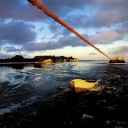
At sunset, I make the familiar climb to the top of St Paul’s dome, high above Whangaroa township. A father and son are up there—the boy is training for a school cross-country—and we take in the view together. The flat peak of Taratara stands on the western skyline under a blaze of orange clouds. Boats at anchor cast their reflections into a glowing sea. The liquid arms of the harbour flow in and out of the forested hills, a tide that embraces old realities and, yes, new beginnings.