Caffyn around Alaska
Paul Caffyn lives on the West Coast and paddles the world. He has already become the first person to kayak around Britain, New Zealand, Japan and Australia. Now he is set to chalk up another great circumnavigation: the coastline of Alaska.He tells the story of the journey so far…
The trouble with being ad‑dicted to sea kayaking is that the immediate period following the conclusion of a successful trip is not one of elation and satisfaction, as you might expect, but is more akin to post-natal depression. The elusive goal has been attained, there is nothing more to strive for.
I find the best way to cope with post-trip blues is to pull out the world atlas and begin planning another outrageous adventure. And so it was that shortly after my 1985 kayak circumnavigation of Japan I began planning a trip around Alaska.
Since the eastern border of Alaska is landlocked against Canada, I decided to have a crack at paddling from Prince Rupert on the northern coast of British Columbia to Inuvik on the Arctic Coast of Canada. Short of lashing the kayak onto a sled and following a dog team south to Prince Rupert, I would have to be satisfied with what I termed a tidewater (in the sea from start to finish) circumnavigation of Alaska. Although the stretched out length of Alaska’s shoreline totals 33,904 miles, my planned route involved 4,600 miles of paddling, give or take a mile or two.
This trip appealed to me for two main reasons. First, no one had paddled the route before. Second, kayaks and the art of kayaking largely evolved in Alaskan waters. Since all my previous trips had been in waters where dugout canoes or rafts were used by the indigenous population, it felt like I was taking my kayak on a nostalgic trip home.
For three years I accumulated information on Alaska’s coastline, building up a detailed picture of all the things that would affect me, such as the prevailing winds and currents, ice pack break-up dates and how best to deal with the bears. By starting in late winter from Prince Rupert, I felt confident of cracking the whole trip in one season, provided the ice pack allowed me an easy passage past Cape Barrow, the northernmost tip of Alaska.
The problem of food resupply was solved easily when I discovered that sending boxes care of general delivery to coastal village post offices was a widely accepted practice.
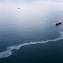
Early evening on March 25, 1989, I had finished sorting and packing my 17 boxes of food in the basement of a friend’s house on Vancouver Island when I was called to watch an item on the television news. I was dismayed to hear of an oil spill in Prince William Sound. The Exxon Valdez had strayed out of its shipping lane and run aground on Bligh Reef, spewing 11 million gallons of oil into the sound.
Although the sound was on my projected route, I wasn’t too bothered initially and assumed, as most people did, that the spill would quickly be contained. Ever since 1977, a daily flow of two million barrels of crude oil has been piped from the Arctic coast south across Alaska to the small fishing port of Valdez in Prince William Sound, from where tankers transport the crude south to the Lower 48 (an Alaskan term for the rest of the U.S.A.).
On schedule, but with my usual pre-trip jitters, I paddled away from Prince Rupert and lost touch with the outside world for the next four weeks as I worked northwards through Clarence and Chatham straits towards my first food dump at Elfin Cove. The spring of ’89 was bleak and cold in S.E. Alaska. Streams tumbling out of the forest were freeze-framed as stalagmites of ice, while snow banks lay thickly on the cobble beaches.
It had been a long, hard winter. I didn’t talk to a soul for eight days. When I passed two loggers fishing from a dinghy, I called out a cheery, “Great day for it.” In reply they just grunted at me. I kept paddling.
As the trip progressed, morale and confidence sagged. The kayak was leaking in all three compartments, which necessitated a fire each night to dry out my gear. Sub-zero temperatures morning and night didn’t help my attempts to fix the leaks. I located the pinprick holes by using my mouth to suck air, then tipped white spirits into each hole and lit the fluid to dry out the kevlar. The only way to harden the fibreglass patches was to use the MSR cooker as a flamethrower.
A pod of killer whales was the highlight of that year. The bull was so old, his massive sail-like dorsal fin, a full eight foot high, had drooped down towards his back. Like a mini submarine, he cruised by my bow only 10 feet away.
When I slipped into Elfin Cove, I was considering abandoning the trip. What with the continuing problems of leaks and cold temperatures, I was definitely not enjoying myself. Salmon fishermen at the cove related horror stories of how the oil spill was now totally out of control, and spreading down both sides of Kodiak Island. They reckoned I would end up looking like a slime ball if I continued paddling. I could not bear the idea of paddling through a sound littered with the slimed carcasses of birds and sea otters, nor did I fancy trying to keep my paddle shaft clean of oil — attempting to roll would be comparable to climbing a greasy pole was in top condition. I’d spent the past two months training daily on a wave ski in the West Coast surf in front of my cottage, and had just completed a 200-mile training trip in the inside passages of S.E. Alaska.
The next 430 miles to Cordova has an awesome reputation for rotten weather and huge surf breaking onto exposed beaches. There are only two lee landings, at Yakutat and Icy Bay, which is why I’d spent so much time training in the West Coast surf. I knew of only one party of two who’d kayaked this coast since the turn of the century. One paddler had suffered a broken nose when a bumper dumper wave had smashed his paddle shaft back into his face. In two single kayaks, the men had spent two periods of 36 hours at sea to avoid big surf landings.
On the floating dock, I finished loading my gear and equipment for the next four months, and sufficient food to last to my first food dump at the Yakutat Post Office. Under a leaden sky, three fishermen watched me silently head out into Cross Sound, on a course for Cape Spencer. I had an equally leaden feeling in my gut as I plugged into a low chop, bucking the tidal stream pouring into the sound.
Very few people knew of this trip, and they were all sworn to secrecy. This was partly in response to trauma and stress caused by the maritime authorities in Japan and Tasmania, during earlier trips, and partly because this attempt seemed such a plum to me, ripe for the picking. I didn’t want a paddler from the Lower 48 on my heels. My sole back-up was a hard-case kayaker in Ketchikan whom I would phone each time I reached a food drop post office. I would give Geoff my anticipated ETA and he was only to notify the US Coastguard that I was overdue if he hadn’t heard anything within seven days of that time. I would be totally reliant on my own resources for the next four months. It was total commitment and that’s what I wanted.
Fishermen term the stretch of coast from Cape Spencer to Yakutat “the Fairweather coast”. As he sailed northwards in 1778, Captain Cook named Cape Fairweather and Mount Fairweather, a 15,300-foot high snow-clad peak only a few miles inland from the cape. The salmon and halibut fishermen reckon Cook must have struck it lucky, and maintain that the term Fairweather is a misnomer. When talking to them about weather and sea conditions, they would scratch their heads and say, “Well, we had a calm day off Cape Fairweather back in ’83, or was it ’82?” I could only hope they were exaggerating.
I must have, like Cook, struck it lucky, for although the sky remained sullenly overcast, the wind stayed light. I passed the four-mile-wide snout of La Perouse Glacier on May 15, and next morning a break in the cloud revealed the magnificence of the Fairweather Range. Shimmering icy peaks, broad neve fields and crevassed glaciers marching towards the sea towered over the coastal strip of forest. I wished for an ice axe and crampons, and promised myself a trip back one day to climb Mt Fairweather.
The 176-mile first stage to Yakutat was in many ways the crux, physically and mentally, of the journey.Having overcome it, not with ease but in style, I knew I had the mettle to carry on with the next 3000 miles.
The next 250-mile leg to Cordova was just as committing, but I now had a psychological edge. In a massive, dumping surf at Point Manby I almost looped end-over-end when the second wave of a set caught me scrambling out of the cockpit onto a steep gravel beach. Catapulted out of the cockpit, I grabbed the bow and struggled clear of the undertow, losing only peace of mind and a water container off the stern.
I made camp in Icy Bay, and was nearly an exposure case within 10 minutes of landing as a vicious blast off the St Elias Mountains funneled out of the bay. The only lee protection on the bare sandspit was a driftlog, and I had endless trouble keeping the tent in contact with the ground until it was firmly guyed to the log.
Next morning I found the tracks of a black bear that had circled the tent during the night. I was well and truly into bear country now. For protection I had a can of Cap Stun — an aerosol with powdered capsicum in a propellant spray. The capsicum affects the respiratory system, mucous membranes and eyes. The person who lent it to me gave a glowing report of its effectiveness in putting down a prison riot at the Bellingham Gaol and a recommendation not to use it, as one poor chap did, as a personal spray-on deterrent.
I slipped out of Icy Bay with an ebbing tide and ran into a solid line of ice. It was not sea ice, but hard glacial ice that is fed into the bay by a host of major glaciers which have their snouts in the Pacific Ocean.
I made Cordova on May 26, dog tired after an all night paddling stint across The Hump but immensely relieved to have completed that exposed section of the Gulf of Alaska.
From Cordova I was able to avoid the gulf for a few days by ducking into the sheltered waters of Prince William Sound. I was busting to find out how badly the oil spill had affected the shores of the sound, and how effective the clean-up operation had been.
Crossing courses with a southbound, laden tanker, I noticed two tenders shadowing its wake, obviously to prevent a repetition of when the boozed skipper of the Exxon Valdez retired below to his cabin and left the third mate to steer the vessel onto Bligh Reef.
Apart from a noticeable absence of sea bird life and otters, I saw little sign of the spill until I landed for the night on the north-eastern end of Evans Island. This gravel beach had been right in the path of the drifting spill. From the high tide mark back to a fringing belt of trees, the beach was coated with oil. An animal, probably a brown bear, had been digging in the beach gravel for shellfish — the pools had filled with water that had an oil sheen on it. I found a campsite under a tree well inland from the beach.
From a count of 36,000 dead birds picked up in Prince William Sound, experts believed this figure represented between 10 and 30 per cent of the total number that perished. One has to wonder about the sanity of the scientists who carried out a study to check the recovery rate of dead birds. They shot 219 perfectly healthy birds and dipped them in crude oil before dropping them into the sound to see what percentage would float and could be recovered.
Amongst sea kayakers , Prince William Sound had a reputation for outstanding scenery and the presence of several pods of killer whales. You couldn’t help bumping into at least one pod. However, in the summer of 1990, exactly 14 months after the spill, I did not sight a single killer whale. The sea and sky were devoid of life.
On June 1, I left the shelter of the sound for the open waters of the gulf en route to my next food drop at the port of Seward. I was apprehensive as I headed offshore but the day was made by a magical experience, one of the highlights of the summer. I heard the sound of a whale spouting and swivelled my head to see a thin spout of misty spume intermittently shooting out of the sea. During past trips I’d been literally scared out of my wits by whales suddenly surfacing alongside the kayak but I’d never had the presence of mind to take a photograph.
This large humpback was regularly spouting three times before sounding and diving to the sea bed for several minutes. I stopped paddling and retrieved the two cameras from my middle compartment. Slinging them round my neck. I resumed my course.
I knew I was in the approximate position where the humpback would surface again, but wasn’t quite prepared for the massive, grey submarine like body surfacing less than 30 feet away, so close that I was drenched by a fine spray when the whale spouted. Its exhaled breath smelt like the stale inside of a fish factory with a tinge of cod liver oil. Twice more the whale spouted, while I clicked the camera shutters. Then the huge tail lifted 15 feet majestically into the air, almost directly over the bow. Click. I hoped trembling hands had not spoilt one of the greatest shots I’d ever taken at sea.
The next big challenge was an exposed 55-mile crossing from Kenai Peninsula to Kodiak Island. Swift tide races and a reputation for rapid weather changes and strong winds left me apprehensive as I kicked out for the Barrens, a small group of islands midway across. It took me two days to complete the crossing, with an overnight stop on the Barren Islands. On both days I was enveloped in thick, damp fog banks. With visibility less than 200 feet, I was absolutely reliant on my deck-mounted binnacle compass, and had to juggle both wind and tidal stream drift to ensure a landfall.
The second leg of the crossing had all the makings of a major epic. I’d waited until 5.30pm for a series of big tide races and overfalls to settle down before launching. Initially, I had a visual sight onto a hazy snow-topped range on Kodiak Island, and was able to correct for tidal drift by checking transits over my shoulder on the Barren Islands. Then, from seawards, I noticed the swirling tendrils of a fog bank sweeping towards me. I scarcely had time to recheck the compass course to Kodiak Island before I was engulfed in a chilling gloom.
For the next three hours I struggled against a choppy beam sea to stay on my compass heading. It was a weather/tide situation, a 15-knot south-easterly blowing against the tide ebbing out of Cook Inlet and pushing up a five-foot breaking chop. By 10.30pm, I should have made contact with land, according to the elapsed timer on my watch. The sea had gone off when the tide began flooding, but I was still totally immersed in a grey-out — I could neither sight land, nor hear the sound of surf on shore.
Re-checking the distance for the umpteenth time, I could only hold my compass heading and try to keep mounting anxiety under control. I wasn’t prepared fora full night at sea: no food handy and the red navigation torch buried deep in the middle compartment.
Fifteen minutes later, I was desperately trying to work out why I’d overshot the island when I noticed a slight increase in the visibility. Glimpses of the sun sinking golden in the west lifted my sagging morale. I kept sweeping my gaze on a 180-degree arc over the bow. Then, a few minutes before 11pm, I glimpsed a faint smear of rock through the fog to my left. It was Dark Island, my aiming point. Wind had pushed me off course by just on a mile. Needless to say, I was pleased to reach terra firma again. I didn’t quite kiss the ground, but that was one tough crossing to have left astern.
During the following three days as I headed down through Shelik of Strait, the few fisherfolk I met shook their heads when I told them where I’d come from. The skipper of the salmon seiner Lady Beth said, “I won’t even take my boat across via the Barren Islands, and she’s a 35-footer!” I was pleased that I’d heard these stories after the crossing.
As I made my way along the Alaska Peninsula my lucky break with reasonable weather came to an end. Each night at 6.30pm, after the television news, a 20-minute programme on the Alaskan weather is broadcast. Mark Evangelista, the hard-case presenter, turns the mundane details about pressure gradients and synoptic situations into a humorous session watched Alaska-wide by aircraft pilots and fishermen. The night I spent at Port William cannery, Mark pointed to a small high pressure cell and said, “Remember this for nostalgia’s sake. It’s the last one we are going to see for a long time.”
For the two weeks it took me to struggle down to my next food dump at Chignik, cold front followed cold front in a seemingly endless succession, with ever so short lulls in between, when I would fight a few miles to the south-west from lee landing to lee landing. Survival became dependent on my ability to read the wind shifts by direction changes in the cloud movement.
When I finally limped into Chignik, 19 days out of Seward, I was shattered physically. All that remained of my food supplies was a couple of dry crackers, a spoonful each of sugar and powdered milk and one freeze-dried meal. Pete Nolan, a jovial Australian fishing boat skipper, plied me with pizzas and tins of meat in an attempt to put some condition back onto my lean frame.
False Pass was the next objective, a narrow channel at the western tip of the Alaska Peninsula where the waters of the Pacific Ocean and the Bering Sea rush through at great speed. Whether it was the pizzas and tins of meat, or a moderate run with semi-settled weather, I averaged 44 miles per day for the next 265 miles to False Pass.
One of my lunch stops en route to False Pass was a gravel beach below
the abandoned village of Belkofski. On a bare grassy slope overlooking the beach stood an ornate and grandiose Russian Orthodox church. All the other buildings apart from the school were ramshackle cottages.
Originally established as a Russian trading settlement, Belkofski was a centre for the rich sea otter hunting grounds. The Aleut sea otter hunters had developed the skills of kayaking and hunting to a state of perfection. Captain Cook was amazed to find that the Aleuts experienced no trouble in keeping pace with his Resolution while it was sailing at a steady seven knots.
Their kayaks, called baidarkas, were works of technological achievement, the only kayaks in the world to have shims of polished ivory or bone inserted between the lashed pieces of the wooden frameworks. These shims prevented wear, and added flexibility to the kayak’s framework. Four or five sea lion skins were cut to shape by the men and sewn by the women over the frame to form a completely waterproof skin.
It was a great tragedy that the Russians first discovered Alaska in 1741. Reports of seas teeming with sea otters led to a stampede by Russian hunters to make their fortunes with what became known as the golden fleeces — the Chinese were insatiable buyers of the short-haired pelts.
These Siberian hunters who became known as the Promyshlenniks were the low life of Russia. Bone and ivory-tipped spears and arrows were no match for Russian firearms and poison. Localized efforts by the Aleut villages to repel the hunters led to bloody massacres and villages being razed to the ground.
One of the worst recorded incidents was perpetrated by Ivan Soloviev, the commander of two trading vessels. At the village of Kashega, he tied 12 Aleuts front-to-back in single file and then fired a musket into the first native. The bullet lodged in the ninth Aleut — nine skilled baidarka men killed with a single shot.
By the time Captain Cook visited the Aleutian Islands in 1778 the Aleuts had been completely subjugated by the Russian hunters. Of an original population of 16,000, less than a half remained. They never recovered.
On several occasions in the old Aleut hunting grounds I had an eerie, spine-tingling feeling of not being alone at sea. I felt a distinct presence around me, which I could only assume was the spirits of the old baidarka men.
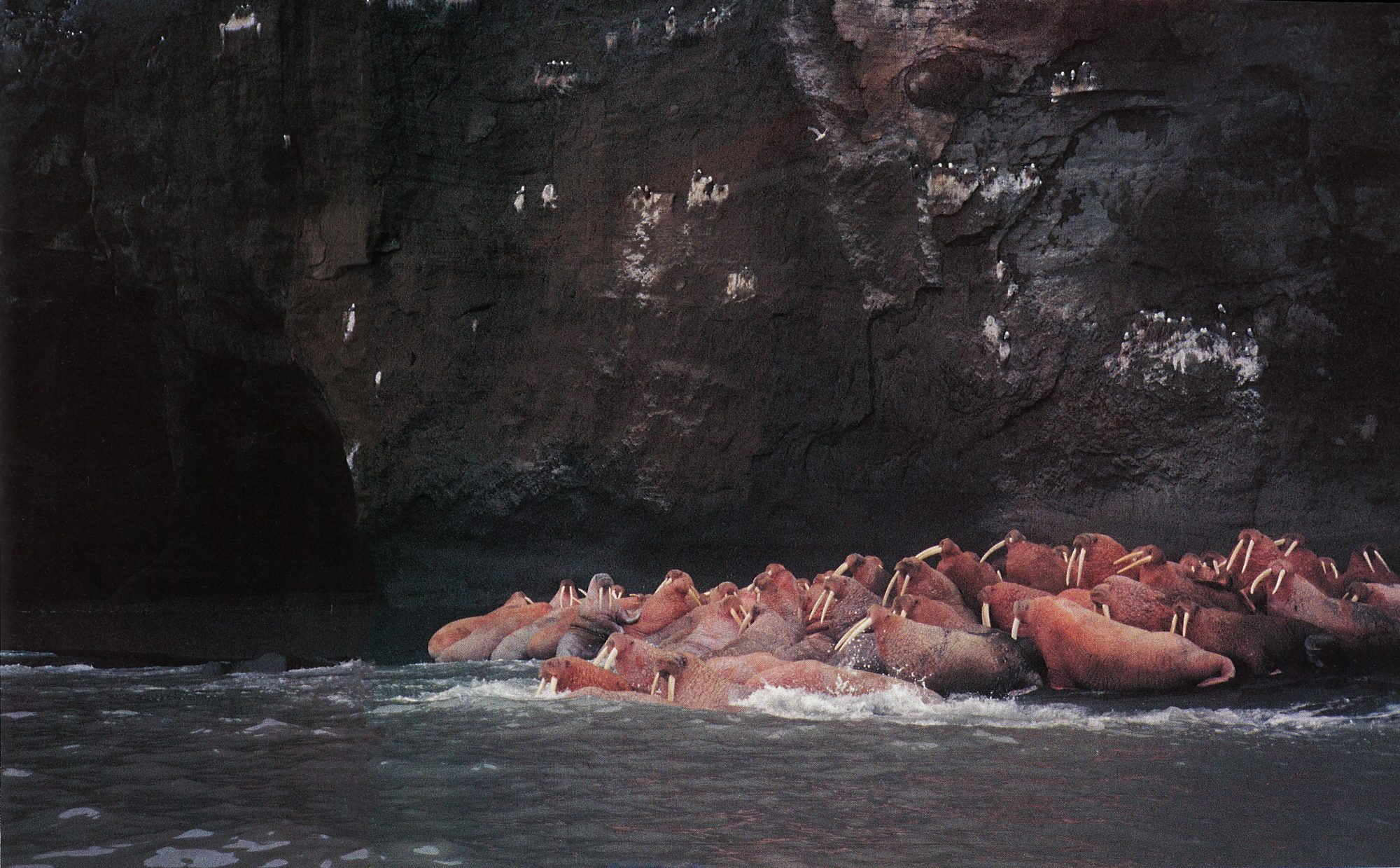
By late afternoon on June 28 I was racing for the shelter of False Pass. I’d rounded up into the lee of Egg Island for lunch and a brief respite from a breaking south-easterly swell. I disturbed a mob of sea otters resting on a rock shelf and had to grin when the mothers grabbed their wee pups in their teeth and dived with them into the sea.
Twenty-five miles of exposed weather shore remained to the entrance of False Pass. Since Egg Island had no fresh water and no level areas to camp, I had to either shoot the gap for False Pass or paddle across to a sandy beach on the mainland. Several times I climbed up onto a high point to gauge the density of whitecaps and feel the wind strength. Deciding it was absolutely marginal, I kicked out for 10 minutes to see if I could cope with conditions. On a five-foot chop, buffeted by williwaws and a showery 25-knot south-easterly, I crossed a deep bay and commenced a four-hour struggle to keep a little distance between me and the surf breaking on a jagged rocky shoreline.
Apart from my arms steadily grinding in 38 paddling strokes a minute, the only thing that kept me from being driven against the rocks and cliffs was the deep draft over-stern rudder. Of all the 89 days of the 1990 trip, this was the one when the rudder was absolutely magical. The wind, gusting to 30 knots with hard driving rain showers, was square on my beam. To correct for wind and chop drift, I had to maintain a course well to the south of the coast. Although I was mostly within a mile of shore, the rain showers were so heavy at times that I was forced onto a compass heading.
More and more cockpit curlers began breaking over the decks. I tried a little bit of forced singing for a while, but then as the wind strength kept increasing, and my body began chilling down, I had to pull the drawstring of the parka hood into a tight circle, with only my nose and eyes peeking out. No more singing.
My first glimpse of the Palisade Cliffs, a vertical tier of sheer rock that guards the entrance to False Pass, brought a shadow of relief. I took note of the compass heading before the visibility socked in again, and gritted my teeth for the last four miles. The wind was raging at a steady 35 knots, driving before it a seven-foot high breaking chop. Rain was pelting down, and my concentration was riveted on making the shelter of the pass. Closing on the cliffs, their tops hidden in cloud, I cast brief glimpses at waterfalls toppling out of the cloud base. Now with the wind and chop on my stern quarter, I was flying along, but holding back on the surf‑ing runs as the chop was too short and too steep. No time for an “end over”.
Bouncing into the shallows, and at last clear of the breakers, I took note of which way the long brown streamers of kelp were lying. The flood tidal stream sets north through False Pass at speeds up to eight knots, and it was almost high water. I bounced through a big rapid with a series of standing pressure waves and was chuffed to find the tide with me. Five miles to the village of False Pass, On a flat sea, broken only by tide races, huge bubbling boils and the odd small overfall, I flew through those five miles at about 12 knots, with a little help from the tide and wind.
Totally exhausted, but wearing a whisker of a smile, I ground the bow onto a gravel beach and staggered ashore. I had just passed the half-way mark to Nome — 1,354 miles down and about the same number to go.
As expected, I found the Bering Sea a complete contrast to the heaving grey seas of the Gulf of Alaska. For the next few weeks, as I headed north-east along the top side of the Alaska Peninsula, the sea was often choppy but there was never a serious swell. I bumped into big mobs of both fishermen and brown bears during those weeks. Early to mid-July was prime time for the Bristol Bay salmon fishery, and also prime time for the big brown bears fishing the river mouths for salmon that had escaped the fishermen’s nets.
I had seen 41 brown bears by the time I camped at Middle Bluff prior to the big 50-mile crossing of Bristol Bay. One had even walked slap bang into my tent and kayak during my first night on the Bering Sea coast, but up till Middle Bluff all the bears I’d seen were reasonably timid, and wombled off in the opposite direction as soon as they got a whiff of my scent. Mind you, the big coastal brown bears, weighing up to 1,200 pounds and standing up to a height of eight or nine feet, are not to be trifled with.
This particular night, I’d backed the tent hard against the base of a big dune ridge. There was plenty of bear sign on the beach — huge plate-like tracks and piles of dung — so I built my usual Caffyn’s patent-pending “bearicade” around the tent. This took the form of whatever I could fabricate from driftwood, the kayak and paddle, so that I would know if a bear was approaching too close to the tent. Unfortunately, by midnight a near-gale was blowing. I had to move the MSR cooker into the tent and lash the paddle to the kayak.
Two hours after midnight, I was dead to the world, sound asleep with the alarm set for 3am. I woke suddenly with the horrendous sound of ripping tent fabric. Realising instantly it was a brown bear, I yelled, “Get out of it!” in my best imitation of Fred Dagg’s voice, along with a few other less salubrious phrases, and groped around in the dark to find my glasses and torch.
There was no need to unzip the tent door, since there was a gaping hole through which I exited the tent.
When I yelled out, the bear had fallen backwards over the kayak before galloping up over the dune ridge. It was only when shining the torch beam at the flapping streamers of nylon that I realised its claws had missed my face by inches.
Next morning I wasn’t sure what to do. I didn’t have enough tape to effect repairs. My needle and dental floss could keep some of the weather out, but I still had over 1000 miles to paddle to reach Nome. Caching the Nordkapp in long grass, I set off with the rolled-up tent to walk 15 miles back towards a fish camp in the hope of finding some duct tape or a sewing machine. I’d only covered 100 yards when a Piper Cub dropped out of the sky and landed on the beach beside me. It was Brad Heile, a salmon spotter I’d met the previous day. Brad flew me into town for breakfast and we were able to patch the tent at one of the local canneries.
As we flew up Bristol Bay we passed over a horde of small but fast boats, all jockeying for postion to set their nets. It looked like the start of the Whitbread race in Auckland, except that ramming and towing of other boat’s nets are accepted practices.
A maximum of 1500 vessels are allowed to work this lucrative fishery. Some 30 million fish return to these waters to spawn each summer, and 50 to 60 per cent of these are caught within a three to four day period. Average catch per boat is 100,000 pounds according to Brad, for an average initial cash return of $1.25 per pound. It is no wonder that the permits go for a top price of $275,000. In a six-week period, fishermen make enough money to live comfortably for the rest of the year.
With a relatively smooth 50-mile crossing of Bristol Bay astern, I thought I was home and hosed, with no major trauma before Nome. But my pre-trip research had left me totally unprepared for the most diabolical of all torments known to a sea kayaker, the vast sprawling mud flats of the Kuskokwim-Yukon delta. I had expected tidal flats, but not extending up to 10 miles offshore.
This area, with its clouds of mosquitoes, soggy tundra and mud flats, is described as the “armpit of Alaska.”
No wonder the fishermen I met off the delta front were always in a hurry. They always stopped to look at the long yellow Nordkapp, but I never had a chance to ask more than one question about what lay ahead, before they would say, “I’m in a hurry to catch the tide.” The fishermen all wore ski goggles to keep the spray out of their eyes as they planed their aluminium skiffs over the short, dirty seas off the delta front.
My fondest dream of the Alaskan trip was to meet one of the traditional skin kayaks at sea. It remained a dream, for I discovered that outboard-powered aluminium dinghies have totally replaced the old skin boats.
At the Yupik Eskimo villages of Tununak and Hooper Bay I was fortunate to see and photograph some of the old kayaks. They were all in an advanced state of decay and disrepair, but, all the same, I was now deep in the country where these kayaks had evolved. Each area had a distinctly different style. Aleut kayaks were sleek and narrow-beamed with tiny cockpits, built for speed on the heaving seas of the Gulf of Alaska. Those of the delta country were short and broad-beamed, with a large round cockpit. After my experiences in the delta, I knew why this style of kayak evolved: the broad beam enabled the paddler to stand up and see where the mud flats ended, and the large cockpit enabled the paddler to curl up and sleep in comfort when he was stranded.
At sunset on August 10 I slipped unnoticed between the twin breakwaters of Nome’s small port entrance and found a scrap of beach to haul the Nordkapp out of the water for the last time. I’d set Nome as my target for the year, but the late summer/early fall weather was so good, I felt tempted to carry on through the Bering Strait to Shishmaref. Following a day of indecision, I rationalised that 89 days and 2,760 miles was sufficient for one season, and decided to shoot the gap for the good old West Coast.
There must have been a tad of intuitive reasoning involved, for I learned that in the following two weeks the Bering Strait area and Kotzebue Sound coast were both battered by the worst fall weather in 15 years.
In June 1991 my plan is to follow the ice pack northwards through the Chuckchi Sea to Barrow, and thence eastwards along the Arctic coast of Alaska to Demarcation Point, which marks the western border of Canada.
The Eskimos have already put the wind up me about polar bears. Brown and black bears are omnivorous, whereas polar bears are strictly carnivorous and not scared of man. I’m reminded of a cartoon strip I once cut out for posterity. It shows an Eskimo practising his kayak rolling technique. Twice he rolls, and each time pops upright with a grin. The third time a grinning polar bear is seated in the cockpit, licking his lips. That’s one good lesson I’ve learned already!