Zoë’s wrath

Tikopia is a tiny tropical island just 4.5 sq km in area, located hundreds of kilometres from the larger islands of the Solomons group to which it belongs. Its 1446 inhabitants lead a subsistence lifestyle: fishing, growing vegetables and rearing chickens and pigs. There is almost no cash economy on the island, where the traditional currency is a rope made from feathers.
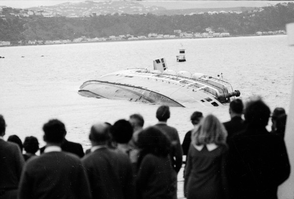
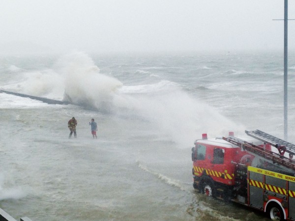
Tikopia’s tranquil world was shattered on the evening of December 27, 2002, when Tropical Cyclone Zoë, probably the most intense storm ever tracked by forecasters in the South Pacific, struck the island. Hurricane-force winds snapped or toppled trees and tore down houses. Plants, blasted by flying sand or burned by salt spray, were stripped of their foliage. The low-pressure centre of the cyclone raised the sea level, and giant waves drove across low-lying land, destroying the buildings and gardens in their path.
A four-metre-high sand ridge which protected the island’s shallow freshwater lake was obliterated, along with the houses on it. The occupants and the debris from their homes were carried across the lake and deposited on the far side. Miraculously, no one was killed, although some people remained in the lake throughout eight hours of darkness, holding small children above the water. After dawn they managed to reach higher ground partially protected by rock overhangs. There they endured two more days of extreme winds as the remaining vegetation disintegrated around them.
When Zoë finally moved away, the devastation was revealed. The island was almost devoid of plant life. Most buildings had been destroyed, and the ones which still stood were badly damaged. The freshwater lake was half filled in and open to the ocean. All the fish in the lake had been killed by the influx of salt water.
The muddy areas where swamp taro had been grown were covered in sand and coral debris. Torrential rain had washed much of the topsoil away, and what remained had been soaked by salt spray. Fallen trees blocked all the tracks across the island, and the water supply system was badly damaged.
As well as destroying the sand ridge protecting the lake, the waves had also washed away an 80 m beach which had lain in front of it, carrying off many canoes.
Although no one was killed and only one person suffered a broken bone, the threat of illness and disease continues to hang over the islanders. With their agricultural base gone, and living in makeshift shelters, they face a difficult future. It is likely that many will have to leave Tikopia and live with relatives in other parts of the Solomons.
Even smaller than Tikopia, with an area of just over one square kilometre, the nearby island of Anuta, 75 km to the north-east and home to 232 villagers, also suffered badly in the storm. Many of its gardens were lost, but most buildings remained intact, partly because of a three-metre-high seawall made from blocks of coral. Although some sea water did flow over the top of the wall, the waves were prevented from driving through the settlement.
Using satellite images, forecasters estimated that Zoë became a Category Five* hurricane when it was close to Tikopia, with winds in excess of 135 knots and a central pressure close to 900 hPa. There were no meteorological instruments on the islands, nor any ships nearby, so no surface observations of wind or pressure were available to verify these estimates. However, the scale of damage was consistent with a storm of this intensity.
Zoë approached Tikopia from the north-east, but as it passed it changed direction by about 90 degrees and moved away towards the south-east on a path that took it safely between Vanuatu and Fiji. Once it reached the north Tasman Sea it stalled and slowly weakened over the relatively cool sea surface there.
Zoë is a good example of the type of storm that would have been missed by forecasters in the days before weather satellites. When it struck, Tikopia and Anuta did not have two-way radio contact with the outside world, and ships visit the islands only about once every five months, so the only sign meteorologists would have had that a major hurricane had occurred would have been large swells on the beaches of Vanuatu and Fiji.
Indeed, one of the revelations regular satellite images have brought is just how many tropical cyclones occur each year. The northeast Pacific in particular, to the west of Mexico and California, was thought to be one of the least active areas for tropical cyclones, but it has turned out to be second only to the northwest Pacific, where tropical cyclones can occur in any month of the year.
Since their first availability, satellite images have steadily improved, becoming more detailed and arriving more frequently. Furthermore, they are not limited to the standard visible and infrared pictures used on television weather reports. Among the innovations of the last 10 years are microwave scanners, which use wavelengths that pass through normal clouds but are absorbed and scattered by raindrops and ice particles. Microwaves with a frequency of 85 GHz are particularly good at highlighting the ice particles produced by thunderstorms. The images they produce are ideal for tracking cyclones which have cloud obscuring their centres and would otherwise be hard to locate accurately (see satellite image on page 15).
Another important use for microwave scanners has been to measure rainfall over the tropical oceans. Until recently the amount of precipitation over these warm seas was largely unknown, yet the latent heat released by water changing from gas to liquid in tropical rain clouds represents one of the largest heat sources in the atmosphere and has a defining influence on global weather patterns in mid-latitudes.
Radar data from a detector installed on one weather satellite is also enabling meteorologists to calculate rainfall and to test the theory that the heat given off by cities increases rainfall by boosting the upward motion of air in cumulus clouds. The concrete and asphalt jungles of large cities absorb a lot of heat from sunlight, and can raise air temperatures as much as 10ºC above those of the surrounding countryside. Rainfall around five US cities, including
Atlanta, Nashville and Dallas, was measured during the warm season, and increases of between 15 and 50 per cent were found in the areas 20 to 60 km downwind of the city centers over the upwind areas.
It seems that giving off a lot of hot air can lead to unforeseen consequences in this delicately balanced atmosphere of ours.